FAA INFORMATION EFFECTIVE 14 MAY 2026
Location
| FAA Identifier: | MYJ |
| Lat/Long: | 39-09-27.0410N 091-49-05.7510W
39-09.450683N 091-49.095850W
39.1575114,-91.8182642
(estimated) |
| Elevation: | 822.6 ft. / 250.7 m (surveyed) |
| Variation: | 02E (2000) |
| From city: | 3 miles E of MEXICO, MO |
| Time zone: | UTC -5 (UTC -6 during Standard Time) |
| Zip code: | 65265 |
Airport Operations
| Airport use: | Open to the public |
| Activation date: | 04/1940 |
| Control tower: | no |
| ARTCC: | KANSAS CITY CENTER |
| FSS: | SAINT LOUIS FLIGHT SERVICE STATION |
| NOTAMs facility: | STL (NOTAM-D service available) |
| Attendance: | MON-FRI 0800-1700, ALL SAT 0800-1500, ALL SUN 1000-1400 |
| Wind indicator: | lighted |
| Segmented circle: | yes |
| Lights: | ACTVT MALS RWY 24; REIL RWY 18; PAPI RWY 24 - CTAF. MIRL RWY 06/24 & 18/36 SS-SR LOW INTST; INCR INTST - CTAF. |
| Beacon: | white-green (lighted land airport)
Operates sunset to sunrise. |
Airport Communications
| CTAF: | 122.9 |
| WX AWOS-3PT: | 120.575 (573-581-7868) |
| MIZZU APPROACH: | 124.375 [OPR 1300-0500Z++ MON-FRI; 1400-2300Z++ SAT-SUN; CLSD HOL.] |
| MIZZU DEPARTURE: | 124.375 [OPR 1300-0500Z++ MON-FRI; 1400-2300Z++ SAT-SUN; CLSD HOL.] |
Nearby radio navigation aids
| VOR radial/distance | | VOR name | | Freq | | Var |
|---|
| HLVr074/14.7 | | HALLSVILLE VORTAC | | 114.20 | | 06E |
| COUr042/27.9 | | COLUMBIA VOR/DME | | 110.20 | | 00E |
Airport Services
| Fuel available: | 100LL JET-A MOGAS
100LL:100LL 24 HR CREDIT CARD FUEL SYSTEM. FOR JET A FUEL AFTER HRS CALL AIRPORT MGR 573-473-7758. |
| Parking: | tiedowns |
| Airframe service: | MAJOR |
| Powerplant service: | MAJOR |
| Bottled oxygen: | NONE |
| Bulk oxygen: | NONE |
Runway Information
Runway 6/24
| Dimensions: | 5501 x 100 ft. / 1677 x 30 m |
| Surface: | concrete, in good condition |
| Weight bearing capacity: | | Single wheel: | 30.0 | | Double wheel: | 37.0 |
|
| Runway edge lights: | medium intensity |
| RUNWAY 6 | | RUNWAY 24 |
| Latitude: | 39-09.257452N | | 39-09.630533N |
| Longitude: | 091-49.532025W | | 091-48.471225W |
| Elevation: | 822.6 ft. | | 808.4 ft. |
| Traffic pattern: | left | | left |
| Runway heading: | 064 magnetic, 066 true | | 244 magnetic, 246 true |
| Displaced threshold: | 200 ft. | | 371 ft. |
| Markings: | nonprecision, in good condition | | nonprecision, in good condition |
| Visual slope indicator: | | | 4-light PAPI on left (3.00 degrees glide path) |
| Approach lights: | | | MALS: 1,400 foot medium intensity approach lighting system |
| Touchdown point: | yes, no lights | | yes, no lights |
| Instrument approach: | | | LOC/DME |
| Obstructions: | none | | 59 ft. trees, 1770 ft. from runway, 278 ft. right of centerline, 26:1 slope to clear
RWY 24 36:1 BASED ON DSPLCD THR. |
Runway 18/36
| Dimensions: | 3200 x 50 ft. / 975 x 15 m |
| Surface: | asphalt/concrete, in fair condition |
| Weight bearing capacity: | |
| Runway edge lights: | medium intensity |
| RUNWAY 18 | | RUNWAY 36 |
| Latitude: | 39-09.725580N | | 39-09.198733N |
| Longitude: | 091-49.247790W | | 091-49.267828W |
| Elevation: | 811.6 ft. | | 817.9 ft. |
| Traffic pattern: | left | | left |
| Runway heading: | 180 magnetic, 182 true | | 000 magnetic, 002 true |
| Markings: | basic, in good condition | | basic, in good condition |
| Runway end identifier lights: | yes | | |
| Touchdown point: | yes, no lights | | yes, no lights |
Airport Ownership and Management from official FAA records
| Ownership: | Publicly-owned |
| Owner: | CITY OF MEXICO
300 N. COAL
MEXICO, MO 65265
Phone 573-581-2100 |
| Manager: | JAY JACOBI
5720 HWY 54 EAST
MEXICO, MO 65265
Phone 573-581-0162 |
Additional Remarks
| - | CROP DUSTING ACFT ON & INVOF ARPT. |
| - | FOR CD CTC MIZZOU APCH AT 417-868-5620/5619. |
Instrument Procedures
NOTE: All procedures below are presented as PDF files. If you need a reader for these files, you should download the free Adobe Reader.NOT FOR NAVIGATION. Please procure official charts for flight.
FAA instrument procedures published for use from 14 May 2026 at 0901Z to 11 June 2026 at 0900Z.
IAPs - Instrument Approach Procedures |
|---|
| RNAV (GPS) RWY 06 | |
download (233KB) |
| RNAV (GPS) RWY 24 | |
download (231KB) |
| LOC RWY 24 | |
download (192KB) |
| VOR/DME RWY 24 | |
download (190KB) |
| NOTE: Special Take-Off Minimums/Departure Procedures apply | |
download (440KB) |
Other nearby airports with instrument procedures:
KFTT - Elton Hensley Memorial Airport (21 nm SW)
KCOU - Columbia Regional Airport (28 nm SW)
K52 - Cpt. Ben Smith Airfield/Monroe City (29 nm N)
H19 - Bowling Green Municipal Airport (31 nm NE)
KMBY - Omar N Bradley Airport (34 nm NW)
|
|

Road maps at:
MapQuest
Bing
Google
| Aerial photo |
|---|
WARNING: Photo may not be current or correct

Do you have a better or more recent aerial photo of Mexico Memorial Airport that you would like to share? If so, please send us your photo.
|
| Sectional chart |
|---|
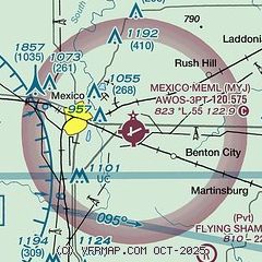
|
| Airport distance calculator |
|---|
|
|
| Sunrise and sunset |
|---|
|
Times for 20-May-2026
| | Local
(UTC-5) | | Zulu
(UTC) |
|---|
| Morning civil twilight | | 05:20 | | 10:20 |
| Sunrise | | 05:51 | | 10:51 |
| Sunset | | 20:17 | | 01:17 |
| Evening civil twilight | | 20:47 | | 01:47 |
|
| Current date and time |
|---|
| Zulu (UTC) | 20-May-2026 15:12:42 |
|---|
| Local (UTC-5) | 20-May-2026 10:12:42 |
|---|
|
| METAR |
|---|
| KMYJ | 201455Z AUTO 01007KT 10SM BKN017 12/09 A3026 RMK AO2
|
|
| TAF |
|---|
KCOU
28nm SW | 201120Z 2012/2112 03008KT P6SM OVC050 FM210300 06007KT P6SM OVC050
|
|
| NOTAMs |
|---|
NOTAMs are issued by the DoD/FAA and will open in a separate window not controlled by AirNav.
|
|

