FAA INFORMATION EFFECTIVE 14 MAY 2026
Location
| FAA Identifier: | GUY |
| Lat/Long: | 36-41-02.9597N 101-30-25.0871W
36-41.049328N 101-30.418118W
36.6841555,-101.5069686
(estimated) |
| Elevation: | 3125.4 ft. / 952.6 m (surveyed) |
| Variation: | 09E (1985) |
| From city: | 1 mile W of GUYMON, OK |
| Time zone: | UTC -5 (UTC -6 during Standard Time) |
| Zip code: | 73942 |
Airport Operations
| Airport use: | Open to the public |
| Activation date: | 05/1949 |
| Control tower: | no |
| ARTCC: | KANSAS CITY CENTER |
| FSS: | MC ALESTER FLIGHT SERVICE STATION |
| NOTAMs facility: | GUY (NOTAM-D service available) |
| Attendance: | MON-SAT 0700-1800, ALL SUN 0800-1700
FOR ATTENDANT AFT HRS CALL 580-338-0481/7700. |
| Wind indicator: | lighted |
| Segmented circle: | yes |
| Lights: | ACTVT ODALS RWY 18; VASI RWY 18; PAPI RWY 36; MIRL RWY 18/36 - CTAF. MIRL RWY 18/36 PRESET LOW INTST, INCR INTST - CTAF. |
| Beacon: | white-green (lighted land airport)
Operates sunset to sunrise. |
Airport Communications
| CTAF/UNICOM: | 122.7 |
| WX ASOS: | 119.925 (580-754-2113) |
- APCH/DEP CTL SVC PRVDD BY KANSAS CITY ARTCC (ZKC) ON FREQS 134.0/257.625 (LIBERAL RCAG).
Airport Services
| Fuel available: | 100LL JET-A+ |
| Parking: | hangars and tiedowns |
| Airframe service: | MAJOR |
| Powerplant service: | MAJOR |
| Bottled oxygen: | NONE |
| Bulk oxygen: | HIGH/LOW |
Runway Information
Runway 18/36
| Dimensions: | 5904 x 100 ft. / 1800 x 30 m |
| Surface: | asphalt, in excellent condition |
| Weight bearing capacity: | |
| Runway edge lights: | medium intensity |
| RUNWAY 18 | | RUNWAY 36 |
| Latitude: | 36-41.587383N | | 36-40.620215N |
| Longitude: | 101-30.403370W | | 101-30.532610W |
| Elevation: | 3102.8 ft. | | 3109.4 ft. |
| Traffic pattern: | right | | left |
| Runway heading: | 177 magnetic, 186 true | | 357 magnetic, 006 true |
| Markings: | nonprecision, in good condition | | nonprecision, in good condition |
| Visual slope indicator: | 4-box VASI on left (3.00 degrees glide path) | | 4-light PAPI on left (3.00 degrees glide path) |
| Approach lights: | ODALS: omnidirectional approach lighting system | | |
| Touchdown point: | yes, no lights | | yes, no lights |
| Obstructions: | none | | 19 ft. tree, 368 ft. from runway, 156 ft. left of centerline, 8:1 slope to clear |
Runway 6/24
| Dimensions: | 1795 x 200 ft. / 547 x 61 m |
| Surface: | turf, in fair condition |
| Runway edge markings: | EDGES MARKED W/ RAISED WOODEN MRKRS. |
| Operational restrictions: | RWY 06 DEP NA. |
| RUNWAY 6 | | RUNWAY 24 |
| Latitude: | 36-40.828167N | | 36-40.912167N |
| Longitude: | 101-30.430167W | | 101-30.078000W |
| Elevation: | 3115.0 ft. | | 3092.0 ft. |
| Traffic pattern: | left | | left |
| Runway heading: | 065 magnetic, 074 true | | 245 magnetic, 254 true |
| Markings: | none, in fair condition | | none, in fair condition |
| Touchdown point: | yes, no lights | | yes, no lights |
Airport Ownership and Management from official FAA records
| Ownership: | Publicly-owned |
| Owner: | CITY OF GUYMON
424 N MAIN
GUYMON, OK 73942
Phone 580-338-3396 |
| Manager: | GREGG R DOWNING
PO BOX 1510
GUYMON, OK 73942
Phone 580-338-7700 |
Additional Remarks
| A39-18/36 | PCR VALUE: 130/F/D/X/T |
| - | ARPT COURTESY CAR AVBL. |
| - | NUMEROUS WATERFOWL INVOF ARPT SR & SS. |
| - | FOR CD CTC KANSAS CITY ARTCC AT 913-254-8508. |
Instrument Procedures
NOTE: All procedures below are presented as PDF files. If you need a reader for these files, you should download the free Adobe Reader.NOT FOR NAVIGATION. Please procure official charts for flight.
FAA instrument procedures published for use from 14 May 2026 at 0901Z to 11 June 2026 at 0900Z.
IAPs - Instrument Approach Procedures |
|---|
| RNAV (GPS) RWY 18 | |
download (232KB) |
| RNAV (GPS) RWY 36 | |
download (269KB) |
| NOTE: Special Alternate Minimums apply | |
download (146KB) |
| NOTE: Special Take-Off Minimums/Departure Procedures apply | |
download (345KB) |
Other nearby airports with instrument procedures:
KEHA - Elkhart-Morton County Airport (26 nm NW)
E19 - Gruver Municipal Airport (27 nm S)
KHQG - Hugoton Municipal Airport (29 nm N)
E42 - Major Samuel B Cornelius Field Airport (32 nm SE)
KLBL - Liberal Mid-America Regional Airport (34 nm NE)
|
|

Road maps at:
MapQuest
Bing
Google
| Aerial photo |
|---|
WARNING: Photo may not be current or correct
 Photo by Ron Lee
Do you have a better or more recent aerial photo of Guymon Municipal Airport that you would like to share? If so, please send us your photo.
|
| Sectional chart |
|---|
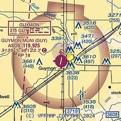
|
| Airport distance calculator |
|---|
|
|
| Sunrise and sunset |
|---|
|
Times for 22-May-2026
| | Local
(UTC-5) | | Zulu
(UTC) |
|---|
| Morning civil twilight | | 06:05 | | 11:05 |
| Sunrise | | 06:35 | | 11:35 |
| Sunset | | 20:51 | | 01:51 |
| Evening civil twilight | | 21:20 | | 02:20 |
|
| Current date and time |
|---|
| Zulu (UTC) | 22-May-2026 22:48:48 |
|---|
| Local (UTC-5) | 22-May-2026 17:48:48 |
|---|
|
| METAR |
|---|
| KGUY | 222153Z AUTO 05012G20KT 10SM CLR 23/12 A2989 RMK AO2 SLP083 T02280117 $
|
|
| TAF |
|---|
| KGUY | 221729Z 2218/2318 02016G26KT P6SM SCT030 FM222200 05012KT P6SM FEW045 FM230500 05006KT P6SM SCT035 BKN100 PROB30 2306/2312 3SM TSRA BR OVC025CB FM231400 10010KT P6SM BKN060
|
|
| NOTAMs |
|---|
NOTAMs are issued by the DoD/FAA and will open in a separate window not controlled by AirNav.
|
|

