FAA INFORMATION EFFECTIVE 09 JULY 2026
Location
| FAA Identifier: | LGU |
| Lat/Long: | 41-47-30.3740N 111-51-05.9300W
41-47.506233N 111-51.098833W
41.7917706,-111.8516472
(estimated) |
| Elevation: | 4456.9 ft. / 1358 m (estimated) |
| Variation: | 11E (2020) |
| From city: | 3 miles NW of LOGAN, UT |
| Time zone: | UTC -6 (UTC -7 during Standard Time) |
| Zip code: | 84335 |
Airport Operations
| Airport use: | Open to the public |
| Activation date: | 11/1937 |
| Control tower: | no |
| ARTCC: | SALT LAKE CITY CENTER |
| FSS: | CEDAR CITY FLIGHT SERVICE STATION |
| NOTAMs facility: | LGU (NOTAM-D service available) |
| Attendance: | 0800-1900 |
| Wind indicator: | lighted |
| Segmented circle: | yes |
| Lights: | ACTVT MALSR RWY 17; REIL RWY 35; PAPI RWY 17 & 35; HIRL RWY 17/35 - CTAF. |
| Beacon: | white-green (lighted land airport)
Operates sunset to sunrise. |
| Landing fee: | yes, LANDING FEE, CTC AMGR FOR MORE INFO. |
| Fire and rescue: | ARFF index B |
Airport Communications
| CTAF/UNICOM: | 122.8 |
| WX ASOS: | 135.275 (435-752-6941) |
| WX AWOS-3 at BMC (17 nm SW): | 135.075 (435-723-3852) |
- COMMUNICATIONS PRVDD BY CEDAR CITY RADIO ON FREQ 122.2. (FRANCIS PEAK RCO)
- APCH/DEP CTL SVC PRVDD BY SALT LAKE ARTCC (ZLC) ON 127.7/354.125 (MALAD CITY RCAG).
Nearby radio navigation aids
| VOR radial/distance | | VOR name | | Freq | | Var |
|---|
| LHOr077/7.1 | | BRIGHAM CITY VOR/DME | | 112.90 | | 14E |
| OGDr004/35.8 | | OGDEN VORTAC | | 115.70 | | 14E |
| MLDr115/36.3 | | MALAD CITY VOR/DME | | 117.40 | | 17E |
Airport Services
| Fuel available: | 100LL JET-A
100LL:AVBL H24 WITH CREDIT CARD; AFT HR - 435-753-2221/435-752-5955. |
| Parking: | hangars and tiedowns |
| Airframe service: | MAJOR |
| Powerplant service: | MAJOR |
| Bulk oxygen: | HIGH/LOW |
Runway Information
Runway 17/35
| Dimensions: | 9020 x 100 ft. / 2749 x 30 m |
| Surface: | asphalt, in excellent condition |
| Weight bearing capacity: | | Single wheel: | 24.0 | | Double wheel: | 179.0 |
|
| Runway edge lights: | high intensity |
| RUNWAY 17 | | RUNWAY 35 |
| Latitude: | 41-48.350697N | | 41-46.867517N |
| Longitude: | 111-50.858415W | | 111-50.952522W |
| Elevation: | 4456.8 ft. | | 4456.4 ft. |
| Traffic pattern: | left | | left |
| Runway heading: | 172 magnetic, 183 true | | 352 magnetic, 003 true |
| Declared distances: | TORA:9020 TODA:9020 ASDA:9020 LDA:9020 | | TORA:9020 TODA:9020 ASDA:9020 LDA:9020 |
| Markings: | precision, in good condition | | precision, in good condition |
| Visual slope indicator: | 2-light PAPI on left (3.00 degrees glide path) | | 2-light PAPI on left (3.00 degrees glide path) |
| Approach lights: | MALSR: 1,400 foot medium intensity approach lighting system with runway alignment indicator lights | | |
| Runway end identifier lights: | no | | yes |
| Touchdown point: | yes, no lights | | yes, no lights |
| Instrument approach: | ILS/DME | | |
| Obstructions: | 23 ft. rr, 555 ft. from runway, 560 ft. left of centerline, 15:1 slope to clear | | none |
Runway 10/28
| Dimensions: | 4075 x 60 ft. / 1242 x 18 m |
| Surface: | asphalt, in excellent condition |
| Weight bearing capacity: | |
| Operational restrictions: | DALGT USE ONLY. |
| RUNWAY 10 | | RUNWAY 28 |
| Latitude: | 41-47.457580N | | 41-47.099450N |
| Longitude: | 111-51.905740W | | 111-51.147833W |
| Elevation: | 4440.1 ft. | | 4449.7 ft. |
| Traffic pattern: | left | | left |
| Runway heading: | 111 magnetic, 122 true | | 291 magnetic, 302 true |
| Declared distances: | TORA:4075 TODA:4075 | | TORA:4075 TODA:4075 |
| Markings: | basic, in poor condition | | basic, in poor condition |
| Touchdown point: | yes, no lights | | yes, no lights |
| Obstructions: | none | | 23 ft. rr, 485 ft. from runway, 12:1 slope to clear |
Airport Ownership and Management from official FAA records
| Ownership: | Publicly-owned |
| Owner: | LOGAN CITY & CACHE CO
199 N. MAIN
LOGAN, UT 84321
Phone (435) 755-1850 |
| Manager: | BOB LOW
199 N. MAIN
LOGAN, UT 84321
Phone 435-755-1750 |
Additional Remarks
| A39-17/35 | PCR VALUE: 550/F/D/X/T |
| - | BIRDS ON & INVOF ARPT SPRING & SUMMER. |
| - | COLD TEMPERATURE AIRPORT. ALTITUDE CORRECTION REQUIRED AT OR BELOW -14C. |
| - | FLT TRNG INVOF ARPT. |
| - | FOR CD CTC SALT LAKE ARTCC AT 801-320-2568. |
Instrument Procedures
NOTE: All procedures below are presented as PDF files. If you need a reader for these files, you should download the free Adobe Reader.NOT FOR NAVIGATION. Please procure official charts for flight.
FAA instrument procedures published for use from 09 July 2026 at 0901Z to 06 August 2026 at 0900Z.
IAPs - Instrument Approach Procedures |
|---|
| ILS OR LOC/DME RWY 17 | |
download (496KB) |
| RNAV (GPS) RWY 17 | |
download (722KB) |
| RNAV (GPS) RWY 35 | |
download (705KB) |
| NOTE: Special Alternate Minimums apply | |
download (34KB) |
|
|---|
| ORNEY ONE (OBSTACLE) | |
download (226KB) |
| NOTE: Special Take-Off Minimums/Departure Procedures apply | |
download (113KB) |
Other nearby airports with instrument procedures:
KBMC - Brigham City Regional Airport (17 nm SW)
1U7 - Bear Lake County Airport (36 nm NE)
KOGD - Ogden-Hinckley Airport (37 nm S)
KHIF - Hill Air Force Base (40 nm S)
KEVW - Evanston-Uinta County Airport - Burns Field (48 nm SE)
|
|

Road maps at:
MapQuest
Bing
Google
| Aerial photo |
|---|
WARNING: Photo may not be current or correct
 Photo by Bill Helber
Photo taken 02-Jul-2011
looking north.
Photo by Bill Helber
Photo taken 02-Jul-2011
looking north.
Do you have a better or more recent aerial photo of Logan-Cache Airport that you would like to share? If so, please send us your photo.
|
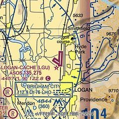
| Sectional chart |
|---|
|
| Airport distance calculator |
|---|
|
|
| Sunrise and sunset |
|---|
|
Times for 02-Aug-2026
| | Local
(UTC-6) | | Zulu
(UTC) |
|---|
| Morning civil twilight | | 05:52 | | 11:52 |
| Sunrise | | 06:23 | | 12:23 |
| Sunset | | 20:44 | | 02:44 |
| Evening civil twilight | | 21:15 | | 03:15 |
|
| Current date and time |
|---|
| Zulu (UTC) | 02-Aug-2026 10:57:34 |
|---|
| Local (UTC-6) | 02-Aug-2026 04:57:34 |
|---|
|
| METAR |
|---|
| KLGU | 021051Z AUTO 00000KT 10SM CLR 14/06 A2999 RMK AO2 SLP091 T01390061
|
KBMC
17nm SW | 021035Z AUTO 00000KT 10SM CLR 18/04 A2995 RMK AO2
|
|
| TAF |
|---|
| KLGU | 020520Z 0206/0306 16006KT P6SM SCT250 FM020900 VRB03KT 5SM FU SCT250 FM021500 VRB04KT 6SM HZ FEW250 FM022000 23007KT P6SM SKC FM030200 36011KT P6SM SKC
|
|
| NOTAMs |
|---|
NOTAMs are issued by the DoD/FAA and will open in a separate window not controlled by AirNav.
|
|


