FAA INFORMATION EFFECTIVE 14 MAY 2026
Location
| FAA Identifier: | HIF |
| Lat/Long: | 41-07-26.1840N 111-58-23.0030W
41-07.436400N 111-58.383383W
41.1239400,-111.9730564
(estimated) |
| Elevation: | 4789 ft. / 1459.7 m (surveyed) |
| Variation: | 14E (2000) |
| From city: | 6 miles S of OGDEN, UT |
| Time zone: | UTC -6 (UTC -7 during Standard Time) |
| Zip code: | 84056 |
Airport Operations
| Airport use: | Private use. Permission required prior to landing |
| Activation date: | 08/1943 |
| Control tower: | yes |
| ARTCC: | SALT LAKE CITY CENTER |
| FSS: | CEDAR CITY FLIGHT SERVICE STATION |
| NOTAMs facility: | HIF (NOTAM-D service available) |
| Attendance: | SAT-SUN 1600-0000Z++, ALL MON-SAT 1500-0700Z++ |
| Wind indicator: | yes |
| Segmented circle: | no |
| Lights: | SS-SR |
| Beacon: | white-green (lighted land airport)
Operates sunset to sunrise. |
Airport Communications
| ATIS: | 134.925 397.9 |
| HILL GROUND: | 121.6 275.8 [OPR 1500-0700Z++ MON-SAT; 1600-0000Z++ SAT-SUN. 12 JUN - 12 OCT ANNUALLY, 1900Z-0300Z++ SAT-MON, CLSD FED HOL.] |
| HILL TOWER: | 127.15 263.15 251.05 [OPR 1500-0700Z++ MON-SAT; 1600-0000Z++ SAT-SUN. 12 JUN - 12 OCT ANNUALLY, 1900Z-0300Z++ SAT-MON, CLSD FED HOL.] |
| SALT LAKE CITY APPROACH: | 121.1 |
| SALT LAKE CITY DEPARTURE: | 121.1 |
| CLEARANCE DELIVERY: | 124.1 335.8 124.1 |
| EMERG: | 121.5 243.0 |
| OPS: | 381.3 ;ACC RAYMOND 23 CONVOY |
| PMSV METRO: | 342.3 |
| PTD: | 134.75 139.3 372.2 |
| WX ASOS at OGD (5 nm NW): | PHONE 801-622-5600 |
- 342.3, UNUSBL 010-100 BYD 20 NM BLW FL 200; 101-150 BYD 25 NM BLW 15000 FT. WX OBSN NOT FULLY REPORTING 120 DEG-260 DEG. AVBL 1200Z++ MON-2300Z++FRI, CLSD WKEND. DMA HUB DSN 228-7647.
Nearby radio navigation aids
| VOR radial/distance | | VOR name | | Freq | | Var |
|---|
| OGDr123/8.3 | | OGDEN VORTAC | | 115.70 | | 14E |
| TCHr345/16.4 | | WASATCH VORTAC | | 116.80 | | 16E |
Airport Services
| Fuel available: | A++ |
| Airframe service: | MAJOR |
| Powerplant service: | MAJOR |
| Bulk oxygen: | HIGH/LOW |
Runway Information
Runway 14/32
| Dimensions: | 13500 x 200 ft. / 4115 x 61 m |
| Surface: | PEM/porous friction courses, in good condition
FIRST 2800 FT RWY 14 & FIRST 1500 FT RWY 32 GROOVED CONC; MID 9200 FT GROOVED ASPH. |
| Weight bearing capacity: | |
| Runway edge lights: | high intensity |
| RUNWAY 14 | | RUNWAY 32 |
| Latitude: | 41-08.425333N | | 41-06.447398N |
| Longitude: | 111-59.053833W | | 111-57.713267W |
| Elevation: | 4785.3 ft. | | 4780.6 ft. |
| Traffic pattern: | left | | right |
| Runway heading: | 139 magnetic, 153 true | | 319 magnetic, 333 true |
| Declared distances: | TORA:13500 TODA:13500 | | TORA:13500 TODA:13500 |
| Markings: | precision, in good condition | | precision, in good condition |
| Visual slope indicator: | 4-light PAPI on left (2.80 degrees glide path) | | 4-light PAPI on left (2.50 degrees glide path) |
| RVR equipment: | touchdown, midfield, rollout | | touchdown, midfield, rollout |
| Approach lights: | ALSF2: standard 2,400 foot high intensity approach lighting system with centerline sequenced flashers (category II or III)
NSTD LEN 2422 FT. | | ODALS: omnidirectional approach lighting system
NSTD 1450 FT. TALLEST LGT 16 FT 9 IN. |
| Runway end identifier lights: | yes | | yes |
| Touchdown point: | yes, no lights | | yes, no lights |
| Instrument approach: | ILS | | |
Airport Ownership and Management from official FAA records
| Ownership: | U.S. Air Force |
| Owner: | USAF
2849TH AB GP/OT, HILL AFB
OGDEN, UT 84401 |
| Manager: | BASE OPERATIONS
2849TH AB GP/OT, HILL AFB
OGDEN, UT 84401
Phone 801-777-1861 |
Additional Remarks
| E60-32 | HOOK BAK-12B(B) (2584 FT) BAK-14 BAK-12B(B) (1250 FT) |
| E60-14 | BAK-14 BAK-12B(B) (1250 FT) HOOK BAK-12B(B) (2574 FT) |
| - | CTN: HVY TFC ON APCH & DEP; EXP TURB APCH & LDG RWY 14 DURG MED - HI SFC WINDS; WIND VELOCITY MAY VARY FM APCH TO DEP END OF RWY. |
| - | CAUTION: DO NOT MISTAKE OGDEN ARPT 4.5 NM N FOR HILL AFB. ACFT DEP SHOULD NOT EXCEED 6300' TIL PAST DEP END OF RWY TO AVOID OVERHEAD TFC PAT. |
| - | TFC PAT: RECTANGULAR 6300', OVERHEAD 6800', MAINT 6800' TIL TURNING BASE LEG. USAF (AF, ANG, AFRC) FTR ACFT EXP REDUCED RWY SEPARATION DAY, VFR-3000' BTN SIMILAR ACFT, 6000' BTN DISSIMILAR ACFT. VARIATIONS EXIST FOR DIFFERENT TYPE OPR. |
| - | TFC PAT: TRAN FTR ACFT MUST NOTIFY TWR ON INITIAL CTC IF REDUCED RWY SEPARATION IS NOT DESIRED. |
| - | NS ABTMT: STRICT ADHERENCE TO NS ABTMT RQR. TRAN ACFT RSTD TO STR-IN FULL STOP ONLY ON WEEKENDS, HOL, AND ON WKD BTW 0000-1500Z++ DAILY. |
| - | CSTMS/AG/IMG: CSTMS/IMG AVBL TO ACC AND AMC FLT. SEE FCG KHIF ENTRY. |
| - | BEARING STRENGTH RWY 14-32: ST175 |
| - | CTN: PRCHT OPS E OF OGDEN ARPT 4 MI N OF HIF 1 MI E OF FINAL. |
| - | A-GEAR: BAK-12B DEP END ACTIVE RWY IN RAISED POSN; 15 MIN/30 MIN NON-DUTY HR PN RQR TO ERECT ON APCH END OF ACT RWY; BAK-12B/14 O/R FM TWR. |
| - | UTTR OPS SEE CLOVER CONTROL. OBSN/FCST AVBL MON-THURS 1200-0400Z++ FRI 1200-0200Z++ CTC HILL AFB WX DSN 777-2018. |
| - | RSTD: TSNT WITH UNEXPENDED LIVE ORDNANCE WO PRIOR COORD. |
| - | COM: PMSV METRO 342.3: CEIL & VIS FREQ LOWER ON N END OF RWY & E-SE ALONG MTNS. |
| - | JASU: 4(MA-1A) 7(A/M32A-86) 5(AM32A-60). |
| - | WX MNT BY AN/FMQ-19 ASOS. |
| - | COM: PMSV METRO 342.3; DUE TO OBSTG TRRN PMSV UNUSBL BYD 20 NM BLW 20000 FT & FM 100 - 150 DEGS BYD 25 NM BLW 15000 FT; MAN OBS LTD FM 120 - 260 DEG DUE TO FAC OBSTN. |
| - | TRANS ALERT: 1500Z-0700Z++ MON-SAT; 1600Z-0000Z++ SAT-SUN; CLSD FED HOL. |
| - | FOR CD CTC SALT LAKE CITY APCH AT 801-325-9670. |
| - | CAUTION: RWY COND CODE NOT REPORTED. |
| - | MISC: WX FLT D777-2018 C801-777-2018; WX FLT CLSD SBY VIA COMD POST D777-3007/C801-777-3007; WX FLT UNAVBL - 25 OWS DAVIS MONTHAN AFB DSN 228-6598/6599/6588/C520-228-6598/6599/6588. |
| - | MISC: CLASSIFIED MATERIAL STOR UNAVBL AT AFLD MGMT OPS, CTC COMD POST FOR STOR. |
| - | FLUID: SP PRESAIR LHOX LOX DE-ICE OIL -O-128-133-148-156; JOAP-4 HR PN RQR DSN 777-1861. |
| - | TRANS ALERT: DE-ICING AVBL. |
| - | RSTD: ENGINE RUN OFFLOADS NA. PPR ALL ACFT - BASE AMOPS D777-1861/C801-777-1861. LIFEGUARD/MEDEVAC/SAR/MSN ESSENTIAL ACFT - AMOPS DSN 777-1861/ C801-777-1861 FAX EXTN 2221 ASAP PRIOR TO ARR TO ENSURE COORD. |
| - | RSTD: VIP ACFT CTC PTD 30 MIN PRIOR TO ETA WITH FIRM BLOCK TIME. |
Instrument Procedures
NOTE: All procedures below are presented as PDF files. If you need a reader for these files, you should download the free Adobe Reader.NOT FOR NAVIGATION. Please procure official charts for flight.
FAA instrument procedures published for use from 14 May 2026 at 0901Z to 11 June 2026 at 0900Z.
IAPs - Instrument Approach Procedures |
|---|
| HI-ILS OR LOC Y RWY 14 | |
download (130KB) |
| ILS OR LOC X RWY 14 | |
download (186KB) |
| HI-TACAN RWY 32 | |
download (164KB) |
| HI-TACAN Z RWY 14 | |
download (132KB) |
| TACAN X RWY 14 | |
download (102KB) |
Departure Procedures |
|---|
| DEVLN 1 | |
download (97KB) |
| FREMONT 1 (VECTOR) | |
download (71KB) |
| LGTNG 1 | |
download (97KB) |
| WILLARD 1 (VECTOR) | |
download (58KB) |
| NOTE: Special Take-Off Minimums/Departure Procedures apply | |
download (113KB) |
Other nearby airports with instrument procedures:
KOGD - Ogden-Hinckley Airport (5 nm N)
KSLC - Salt Lake City International Airport (20 nm S)
KBMC - Brigham City Regional Airport (26 nm N)
KSVR - South Valley Regional Airport (30 nm S)
KTVY - Bolinder Field/Tooele Valley Airport (35 nm SW)
|
|

Road maps at:
MapQuest
Bing
Google
| Aerial photo |
|---|
WARNING: Photo may not be current or correct
 Photo by Jeffrey Owen
Photo taken 28-Jul-2008
Photo by Jeffrey Owen
Photo taken 28-Jul-2008
Do you have a better or more recent aerial photo of Hill Air Force Base that you would like to share? If so, please send us your photo.
|
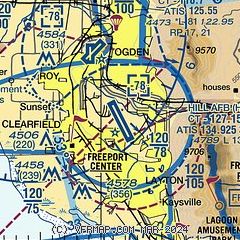
| Sectional chart |
|---|
|
 Download PDF
of official airport diagram from the FAA
| Airport distance calculator |
|---|
|
|
| Sunrise and sunset |
|---|
|
Times for 04-Jun-2026
| | Local
(UTC-6) | | Zulu
(UTC) |
|---|
| Morning civil twilight | | 05:24 | | 11:24 |
| Sunrise | | 05:57 | | 11:57 |
| Sunset | | 20:55 | | 02:55 |
| Evening civil twilight | | 21:28 | | 03:28 |
|
| Current date and time |
|---|
| Zulu (UTC) | 05-Jun-2026 03:27:02 |
|---|
| Local (UTC-6) | 04-Jun-2026 21:27:02 |
|---|
|
| METAR |
|---|
| KHIF | 050255Z AUTO 11006KT 10SM CLR 25/M01 A2994 RMK AO2 SLP076 T02491011 56005
|
KOGD
5nm NW | 050253Z AUTO 11003KT 10SM CLR 27/M02 A2992 RMK AO2 SLP070 T02671017 56005
|
|
| TAF |
|---|
| KHIF | 042100Z 0421/0603 28010KT 9999 SKC QNH2993INS BECMG 0502/0503 10012KT 9999 FEW160 QNH2995INS BECMG 0517/0518 24008KT 9999 SKC QNH2980INS BECMG 0602/0603 11010KT 9999 SCT180 QNH2980INS TX29/0521Z TN16/0512Z
|
KOGD
5nm NW | 041720Z 0418/0518 29009KT P6SM SKC FM050300 35009KT P6SM SKC FM051000 VRB04KT P6SM SKC
|
|
| NOTAMs |
|---|
NOTAMs are issued by the DoD/FAA and will open in a separate window not controlled by AirNav.
|
|


