FAA INFORMATION EFFECTIVE 19 MARCH 2026
Location
| FAA Identifier: | LLQ |
| Lat/Long: | 33-38-18.8000N 091-45-03.6000W
33-38.313333N 091-45.060000W
33.6385556,-91.7510000
(estimated) |
| Elevation: | 267.8 ft. / 81.6 m (surveyed) |
| Variation: | 01E (2010) |
| From city: | 2 miles E of MONTICELLO, AR |
| Time zone: | UTC -5 (UTC -6 during Standard Time) |
| Zip code: | 71655 |
Airport Operations
| Airport use: | Open to the public |
| Activation date: | 07/1947 |
| Control tower: | no |
| ARTCC: | MEMPHIS CENTER |
| FSS: | JONESBORO FLIGHT SERVICE STATION |
| NOTAMs facility: | LLQ (NOTAM-D service available) |
| Attendance: | MON-FRI 0700-1530 |
| Wind indicator: | lighted |
| Segmented circle: | yes |
| Lights: | ACTVT REIL RWYS 03 & 21; PAPI RWYS 03 & 21; MIRL RWY 03/21 - CTAF. |
| Beacon: | white-green (lighted land airport)
Operates sunset to sunrise. |
Airport Communications
| CTAF/UNICOM: | 122.8 |
| WX ASOS: | 133.325 (870-367-1019) |
- APCH/DEP SVC PRVDD BY MEMPHIS ARTCC ON FREQS 135.875/269.35 (GREENVILLE RCAG & PINE BLUFF RCAG).
Nearby radio navigation aids
| VOR radial/distance | | VOR name | | Freq | | Var |
|---|
| PBFr163/37.5 | | PINE BLUFF VOR/DME | | 116.00 | | 04E |
| GLHr276/39.0 | | GREENVILLE VOR/DME | | 114.25 | | 04E |
Airport Services
| Fuel available: | 100LL JET-A
A:SELF SVC FUEL AVBL 24 HRS WITH CREDIT CARD.
100LL:SELF SVC FUEL AVBL 24 HRS WITH CREDIT CARD. |
| Parking: | hangars and tiedowns |
| Airframe service: | MINOR |
| Powerplant service: | MINOR |
| Bottled oxygen: | NONE |
| Bulk oxygen: | NONE |
Runway Information
Runway 3/21
| Dimensions: | 5020 x 75 ft. / 1530 x 23 m |
| Surface: | asphalt, in good condition |
| Weight bearing capacity: | |
| Runway edge lights: | medium intensity |
| RUNWAY 3 | | RUNWAY 21 |
| Latitude: | 33-37.961502N | | 33-38.664685N |
| Longitude: | 091-45.321068W | | 091-44.799020W |
| Elevation: | 267.4 ft. | | 233.8 ft. |
| Traffic pattern: | left | | left |
| Runway heading: | 031 magnetic, 032 true | | 211 magnetic, 212 true |
| Markings: | nonprecision, in good condition | | nonprecision, in good condition |
| Visual slope indicator: | 2-light PAPI on left (3.00 degrees glide path) | | 2-light PAPI on left (3.00 degrees glide path) |
| Runway end identifier lights: | yes | | yes |
| Touchdown point: | yes, no lights | | yes, no lights |
| Obstructions: | 35 ft. pline, marked, 1400 ft. from runway, 34:1 slope to clear | | 15 ft. road, 540 ft. from runway, 150 ft. left of centerline, 22:1 slope to clear |
Airport Ownership and Management from official FAA records
| Ownership: | Publicly-owned |
| Owner: | CITY OF MONTICELLO
PO BOX 505
MONTICELLO, AR 71657
Phone 870-367-4400 |
| Manager: | BENNIE RYBURN
390 AIRPORT RD.
MONTICELLO, AR 71655
Phone 870-723-6611 |
Additional Remarks
| - | FOR CD CTC MEMPHIS ARTCC AT 901-368-8453/8449. |
| - | FBO MANAGER: CARL CHAPPELL 870-367-4450 |
Instrument Procedures
NOTE: All procedures below are presented as PDF files. If you need a reader for these files, you should download the free Adobe Reader.NOT FOR NAVIGATION. Please procure official charts for flight.
FAA instrument procedures published for use from 19 March 2026 at 0901Z to 16 April 2026 at 0900Z.
IAPs - Instrument Approach Procedures |
|---|
| RNAV (GPS) RWY 03 **CHANGED** | |
download (186KB) |
| RNAV (GPS) RWY 21 **CHANGED** | |
download (188KB) |
| NOTE: Special Alternate Minimums apply | |
download (121KB) |
| NOTE: Special Take-Off Minimums/Departure Procedures apply | |
download (401KB) |
Other nearby airports with instrument procedures:
3M9 - Warren Municipal Airport/John B Frazer Jr. Field (17 nm W)
0M0 - Billy Free Municipal Airport (18 nm NE)
7M1 - Mc Gehee Municipal Airport (19 nm E)
M32 - Lake Village Municipal Airport (28 nm SE)
KCRT - Z M Jack Stell Field Airport (28 nm S)
|
|

Road maps at:
MapQuest
Bing
Google
| Aerial photo |
|---|
WARNING: Photo may not be current or correct
 Photo courtesy of the Arkansas Department of Aeronautics
Taken in the Spring of 2007
Photo courtesy of the Arkansas Department of Aeronautics
Taken in the Spring of 2007
Do you have a better or more recent aerial photo of Monticello Municipal Airport/Ellis Field that you would like to share? If so, please send us your photo.
|
| Sectional chart |
|---|
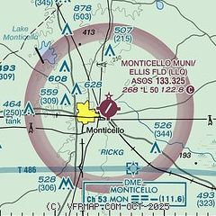
|
| Airport distance calculator |
|---|
|
|
| Sunrise and sunset |
|---|
|
Times for 13-Apr-2026
| | Local
(UTC-5) | | Zulu
(UTC) |
|---|
| Morning civil twilight | | 06:14 | | 11:14 |
| Sunrise | | 06:40 | | 11:40 |
| Sunset | | 19:35 | | 00:35 |
| Evening civil twilight | | 20:01 | | 01:01 |
|
| Current date and time |
|---|
| Zulu (UTC) | 13-Apr-2026 09:18:50 |
|---|
| Local (UTC-5) | 13-Apr-2026 04:18:50 |
|---|
|
| METAR |
|---|
| KLLQ | 130853Z AUTO 20006KT 10SM CLR 22/17 A3012 RMK AO2 SLP195 T02170167 55003 $
|
|
| TAF |
|---|
| KLLQ | 130540Z 1306/1406 19008G16KT P6SM SCT120 BKN250 FM131000 20008KT P6SM OVC025 FM131500 21010G20KT P6SM OVC050
|
|
| NOTAMs |
|---|
NOTAMs are issued by the DoD/FAA and will open in a separate window not controlled by AirNav.
|
|


