FAA INFORMATION EFFECTIVE 16 APRIL 2026
Location
| FAA Identifier: | M32 |
| Lat/Long: | 33-20-47.5000N 091-18-56.0000W
33-20.791667N 091-18.933333W
33.3465278,-91.3155556
(estimated) |
| Elevation: | 126.1 ft. / 38.4 m (surveyed) |
| Variation: | 01W (2020) |
| From city: | 2 miles W of LAKE VILLAGE, AR |
| Time zone: | UTC -5 (UTC -6 during Standard Time) |
| Zip code: | 71653 |
Airport Operations
| Airport use: | Open to the public |
| Activation date: | 04/1970 |
| Control tower: | no |
| ARTCC: | MEMPHIS CENTER |
| FSS: | JONESBORO FLIGHT SERVICE STATION |
| NOTAMs facility: | JBR (NOTAM-D service available) |
| Attendance: | MON-FRI 0700-1700, ALL SAT 0700-1200 |
| Wind indicator: | lighted |
| Segmented circle: | yes |
| Lights: | ACTVT MIRL RWY 01/19, PAPI RWY 01 & 19 - CTAF. |
| Beacon: | white-green (lighted land airport)
Operates sunset to sunrise. |
Airport Communications
| CTAF: | 122.9 |
| WX ASOS at GLH (19 nm NE): | 125.525 (662-332-0863) |
- APCH/DEP SVC PRVDD BY MEMPHIS ARTCC ON FREQS 135.875/269.35 (GREENVILLE RCAG & PINE BLUFF RCAG).
Nearby radio navigation aids
| VOR radial/distance | | VOR name | | Freq | | Var |
|---|
| GLHr233/19.8 | | GREENVILLE VOR/DME | | 114.25 | | 04E |
| NDB name | | Hdg/Dist | | Freq | | Var | | ID |
|---|
| METCALF | | 255/17.4 | | 359 | | 01W | | MTQ | -- - --.- |
Airport Services
| Fuel available: | 100LL JET-A |
| Parking: | tiedowns |
| Airframe service: | NONE |
| Powerplant service: | NONE |
| Bottled oxygen: | NONE |
| Bulk oxygen: | NONE |
Runway Information
Runway 1/19
| Dimensions: | 4400 x 75 ft. / 1341 x 23 m |
| Surface: | asphalt, in good condition |
| Weight bearing capacity: | |
| Runway edge lights: | medium intensity |
| RUNWAY 1 | | RUNWAY 19 |
| Latitude: | 33-20.439082N | | 33-21.143380N |
| Longitude: | 091-19.037802W | | 091-18.830515W |
| Elevation: | 125.9 ft. | | 124.5 ft. |
| Traffic pattern: | left | | left |
| Runway heading: | 015 magnetic, 014 true | | 195 magnetic, 194 true |
| Markings: | nonprecision, in good condition | | nonprecision, in good condition |
| Visual slope indicator: | 2-light PAPI on left (3.00 degrees glide path) | | 2-light PAPI on left (3.00 degrees glide path) |
| Touchdown point: | yes, no lights | | yes, no lights |
| Obstructions: | 24 ft. trees, 1050 ft. from runway, 200 ft. left of centerline, 35:1 slope to clear | | 25 ft. trees, 880 ft. from runway, 255 ft. right of centerline, 27:1 slope to clear |
Airport Ownership and Management from official FAA records
| Ownership: | Publicly-owned |
| Owner: | CITY OF LAKE VILLAGE
PO BOX 725
LAKE VILLAGE, AR 71653
Phone 870-265-2228 |
| Manager: | REAGAN CLARK
925 HIGHWAY 65 & 82
LAKE VILLAGE, AR 71653
Phone 870-265-2723 |
Additional Remarks
| - | NUMEROUS AGRICULTURAL OPNS FEB-OCT BELOW 500 FT. |
| - | FOR CD CTC MEMPHIS ARTCC AT 901-368-8453/8449. |
Instrument Procedures
NOTE: All procedures below are presented as PDF files. If you need a reader for these files, you should download the free Adobe Reader.NOT FOR NAVIGATION. Please procure official charts for flight.
FAA instrument procedures published for use from 16 April 2026 at 0901Z to 14 May 2026 at 0900Z.
IAPs - Instrument Approach Procedures |
|---|
| RNAV (GPS) RWY 01 **CHANGED** | |
download (194KB) |
| RNAV (GPS) RWY 19 **CHANGED** | |
download (204KB) |
| NOTE: Special Take-Off Minimums/Departure Procedures apply | |
download (131KB) |
Other nearby airports with instrument procedures:
7M1 - Mc Gehee Municipal Airport (17 nm N)
KGLH - Greenville Mid-Delta Airport (19 nm NE)
KLLQ - Monticello Municipal Airport/Ellis Field (28 nm NW)
KCRT - Z M Jack Stell Field Airport (30 nm W)
KIDL - Indianola Municipal Airport (33 nm E)
|
|

Road maps at:
MapQuest
Bing
Google
| Aerial photo |
|---|
WARNING: Photo may not be current or correct
 Photo courtesy of the Arkansas Department of Aeronautics
Taken in the Spring of 2007
Photo courtesy of the Arkansas Department of Aeronautics
Taken in the Spring of 2007
Do you have a better or more recent aerial photo of Lake Village Municipal Airport that you would like to share? If so, please send us your photo.
|
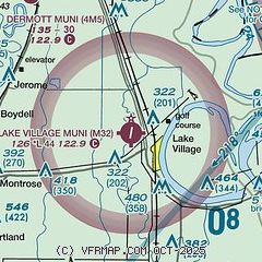
| Sectional chart |
|---|
|
| Airport distance calculator |
|---|
|
|
| Sunrise and sunset |
|---|
|
Times for 29-Apr-2026
| | Local
(UTC-5) | | Zulu
(UTC) |
|---|
| Morning civil twilight | | 05:54 | | 10:54 |
| Sunrise | | 06:20 | | 11:20 |
| Sunset | | 19:45 | | 00:45 |
| Evening civil twilight | | 20:11 | | 01:11 |
|
| Current date and time |
|---|
| Zulu (UTC) | 29-Apr-2026 05:46:27 |
|---|
| Local (UTC-5) | 29-Apr-2026 00:46:27 |
|---|
|
| METAR |
|---|
KGLH
19nm NE | 290453Z AUTO 19008KT 10SM BKN065 21/19 A2987 RMK AO2 TSE0357 SLP118 T02060189
|
KLLQ
28nm NW | 290523Z AUTO VRB04KT 9SM SCT060 20/20 A2988 RMK AO2 LTG DSNT NW-NE T02000200 PNO $
|
KRNV
37nm NE | 290515Z AUTO 23005KT 10SM SCT060 22/20 A2984 RMK AO2 T02210205 $
|
|
| TAF |
|---|
KGLH
19nm NE | 281728Z 2818/2918 18010KT P6SM OVC020 FM282000 19015G25KT 6SM -TSRA BR BKN025CB TEMPO 2820/2822 27020G30KT 1SM TSRA OVC015CB FM290300 20013G21KT P6SM OVC040 FM291300 28009KT P6SM BKN015 AMD NOT SKED
|
|
| NOTAMs |
|---|
NOTAMs are issued by the DoD/FAA and will open in a separate window not controlled by AirNav.
|
|

