FAA INFORMATION EFFECTIVE 16 APRIL 2026
Location
| FAA Identifier: | MER |
| Lat/Long: | 37-22-49.7440N 120-34-05.4710W
37-22.829067N 120-34.091183W
37.3804844,-120.5681864
(estimated) |
| Elevation: | 190.4 ft. / 58.0 m (surveyed) |
| Variation: | 15E (2000) |
| From city: | 3 miles NE of ATWATER, CA |
| Time zone: | UTC -7 (UTC -8 during Standard Time) |
| Zip code: | 95301 |
Airport Operations
| Airport use: | Open to the public |
| Activation date: | 07/1942 |
| Control tower: | yes |
| ARTCC: | OAKLAND CENTER |
| FSS: | RANCHO MURIETA FLIGHT SERVICE STATION |
| NOTAMs facility: | MER (NOTAM-D service available) |
| Attendance: | MON-FRI 0800-1700 |
| Wind indicator: | lighted |
| Segmented circle: | yes |
| Lights: | WHEN ATCT CLSD ACTVT ALSF1 RWYS 13 & 31; HIRL RWY 13/31 - CTAF; 3 CLICKS ON, 5 CLICKS INCR INTST, 7 CLICKS OFF. PAPI RWYS 13 & 31 OPR CONSLY. |
| Beacon: | white-green (lighted land airport)
Operates sunset to sunrise. |
Airport Communications
| CTAF: | 118.175 |
| UNICOM: | 122.95 |
| ATIS: | 124.475 |
| WX AWOS-3: | PHONE 209-725-0104 |
| CASTLE GROUND: | 133.575 [0700-2100] |
| CASTLE TOWER: | 118.175 235.775 [0700-2100] |
| NORCAL APPROACH: | 120.95 |
| NORCAL DEPARTURE: | 120.95 |
| WX ASOS at MCE (6 nm SE): | 132.175 (209-381-0926) |
Nearby radio navigation aids
| VOR radial/distance | | VOR name | | Freq | | Var |
|---|
| HYPr305/12.6 | | EL NIDO VOR/DME | | 113.85 | | 15E |
| MODr112/23.7 | | MODESTO VOR/DME | | 114.60 | | 17E |
Airport Services
| Fuel available: | 100LL JET-A JET-A1
100LL:FOR FUEL FM 1800-0900 CALL (209) 725-1455. |
| Parking: | hangars and tiedowns |
| Airframe service: | MINOR |
| Powerplant service: | MINOR |
Runway Information
Runway 13/31
| Dimensions: | 11802 x 150 ft. / 3597 x 46 m |
| Surface: | asphalt/concrete, in good condition |
| Weight bearing capacity: | | Single wheel: | 155.0 | | Double wheel: | 200.0 | | Double tandem: | 415.0 | | Dual double tandem: | 720.0 |
|
| Runway edge lights: | high intensity |
| Operational restrictions: | 1,000 FT PAVED BLAST PAD BOTH ENDS OF RY. |
| RUNWAY 13 | | RUNWAY 31 |
| Latitude: | 37-23.585087N | | 37-22.072975N |
| Longitude: | 120-34.857533W | | 120-33.325092W |
| Elevation: | 190.4 ft. | | 177.7 ft. |
| Traffic pattern: | left | | right |
| Runway heading: | 126 magnetic, 141 true | | 306 magnetic, 321 true |
| Markings: | nonprecision, in good condition | | precision, in good condition |
| Visual slope indicator: | 4-light PAPI on left (3.00 degrees glide path) | | 4-light PAPI on left (3.00 degrees glide path) |
| Approach lights: | ALSF1: standard 2,400 foot high intensity approach lighting system with centerline sequenced flashers (category I) | | ALSF1: standard 2,400 foot high intensity approach lighting system with centerline sequenced flashers (category I)
ALSF1 RY 13/31 SEQUENCED FLASHING LGTS OTS INDEFLY. |
| Runway end identifier lights: | | | no |
| Touchdown point: | yes, no lights | | yes, no lights |
| Instrument approach: | | | LOC/GS |
Airport Ownership and Management from official FAA records
| Ownership: | Publicly-owned |
| Owner: | MERCED COUNTY
2222 M STREET
MERCED, CA 95340
Phone 209-385-7686
COMMUNITY & ECONOMIC DEVELOPMENT |
| Manager: | GEORGE CLOVER
2222 M STREET
MERCED, CA 95340-4180
Phone 209-617-5399
DESK PHONE 209-385-7686, EXTN 4180. |
Additional Remarks
| - | WHEN ATCT CLSD MAX OF 5 ACFT PMTD IN VFR TFC PAT AT ANY ONE TIME AND 2000 FT CIG AND 3 MIS VIS RCMDD. |
| - | FOR CD WHEN ATCT IS CLSD CTC NORCAL APCH AT 916-361-0516. |
| - | TWY B CLSD TO ACFT GTR THAN 30000 LBS. |
| - | RY 13/31 180 DEGREE TURNS PROHIBITIED. |
| - | FOR ARPT INFO 209-385-7686, EXTN 4180. |
| - | RY 31 WILL BE THE DESIGNATED CALM WIND RY (WIND 5 KNOTS OR LESS). |
| - | OPPOSITE END OF RY NOT VISIBLE ON TKOF. WHEN ATCT CLSD OPPOSITE DIRECTION TAKEOFFS AND LANDINGS ARE NOT AUTHORIZED. |
| - | CIVILIAN AND MILITARY TRAINING MAY OCCASIONALLY CAUSE PATTERN CONGESTION. |
Instrument Procedures
NOTE: All procedures below are presented as PDF files. If you need a reader for these files, you should download the free Adobe Reader.NOT FOR NAVIGATION. Please procure official charts for flight.
FAA instrument procedures published for use from 16 April 2026 at 0901Z to 14 May 2026 at 0900Z.
IAPs - Instrument Approach Procedures |
|---|
| ILS OR LOC RWY 31 **CHANGED** | |
download (269KB) |
| RNAV (GPS) RWY 13 **CHANGED** | |
download (223KB) |
| RNAV (GPS) RWY 31 **CHANGED** | |
download (236KB) |
| NOTE: Special Alternate Minimums apply | |
download (118KB) |
| NOTE: Special Take-Off Minimums/Departure Procedures apply | |
download (128KB) |
Other nearby airports with instrument procedures:
KMCE - Merced Yosemite Regional Airport (6 nm SE)
O15 - Turlock Municipal Airport (9 nm NW)
KMOD - Modesto City-County Airport-Harry Sham Field (24 nm NW)
KLSN - Los Banos Municipal Airport (24 nm SW)
O27 - Oakdale Airport (25 nm NW)
|
|

Road maps at:
MapQuest
Bing
Google
| Aerial photo |
|---|
WARNING: Photo may not be current or correct
 Photo by CW
Photo taken 17-Jun-2011
looking north.
Photo by CW
Photo taken 17-Jun-2011
looking north.
Do you have a better or more recent aerial photo of Castle Airport that you would like to share? If so, please send us your photo.
|
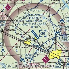
| Sectional chart |
|---|
|
CAUTION: Diagram may not be current
 Download PDF
of official airport diagram from the FAA
| Airport distance calculator |
|---|
|
|
| Sunrise and sunset |
|---|
|
Times for 05-May-2026
| | Local
(UTC-7) | | Zulu
(UTC) |
|---|
| Morning civil twilight | | 05:35 | | 12:35 |
| Sunrise | | 06:04 | | 13:04 |
| Sunset | | 19:54 | | 02:54 |
| Evening civil twilight | | 20:23 | | 03:23 |
|
| Current date and time |
|---|
| Zulu (UTC) | 05-May-2026 18:09:29 |
|---|
| Local (UTC-7) | 05-May-2026 11:09:29 |
|---|
|
| METAR |
|---|
| KMER | 051655Z 33008KT 10SM FEW021 BKN110
|
KMCE
7nm SE | 051753Z AUTO 31009KT 10SM FEW050 OVC085 16/09 A2999 RMK AO2 SLP153 T01610089 10161 20117 51006
|
|
| TAF |
|---|
| KMER | 051120Z 0512/0612 33006KT P6SM BKN040 OVC090 TEMPO 0514/0518 5SM -SHRA BR BKN030 FM052200 34009KT P6SM BKN050 OVC100 FM060300 VRB04KT P6SM SCT050 BKN120 AMD NOT SKED
|
KMCE
7nm SE | 051120Z 0512/0612 34010KT P6SM BKN040 OVC090 TEMPO 0514/0518 5SM -SHRA BR BKN030 FM052200 34009KT P6SM BKN050 OVC100 FM060300 VRB04KT P6SM SCT050 BKN120
|
|
| NOTAMs |
|---|
NOTAMs are issued by the DoD/FAA and will open in a separate window not controlled by AirNav.
|
|


