FAA INFORMATION EFFECTIVE 11 JUNE 2026
Location
| FAA Identifier: | MOD |
| Lat/Long: | 37-37-32.9690N 120-57-15.9480W
37-37.549483N 120-57.265800W
37.6258247,-120.9544300
(estimated) |
| Elevation: | 99.2 ft. / 30.2 m (surveyed) |
| Variation: | 16E (1985) |
| From city: | 2 miles SE of MODESTO, CA |
| Time zone: | UTC -7 (UTC -8 during Standard Time) |
| Zip code: | 95354 |
Airport Operations
| Airport use: | Open to the public |
| Activation date: | 04/1940 |
| Control tower: | yes |
| ARTCC: | OAKLAND CENTER |
| FSS: | RANCHO MURIETA FLIGHT SERVICE STATION |
| NOTAMs facility: | MOD (NOTAM-D service available) |
| Attendance: | MON-FRI 0800 -1630 |
| Wind indicator: | lighted |
| Segmented circle: | yes |
| Lights: | WHEN ATCT CLSD ACTVT MALSR RWY 28R; REIL RWY 10L; PAPI RWY 10L; HIRL RWY 10L/28R - CTAF. PAPI RWYS 10R & 28L AND MIRL RWY 10R/28L UNAVBL WHEN ATCT CLSD. |
| Beacon: | white-green (lighted land airport)
Operates sunset to sunrise. |
| Landing fee: | yes, FEE FOR ACFT OVER 9501 LBS, OVNGT TIEDOWN FEE. |
| Airline operations: | PPR 72 HRS FOR ACR OPNS WITH MORE THAN 30 PSGR SEATS 0800-1700 WKDAYS CALL AMGR (209) 577-5318. |
Airport Communications
| CTAF: | 125.3 |
| UNICOM: | 122.95 |
| ATIS: | 127.7 |
| WX ASOS: | 127.7 (209-572-0914) |
| MODESTO GROUND: | 121.7 [0700-2100] |
| MODESTO TOWER: | 125.3 257.8 [0700-2100] |
| NORCAL APPROACH: | 120.95 |
| NORCAL DEPARTURE: | 120.95 ;060-205 MOD 123.85 ;WEST 125.1 ;NORTH |
Nearby radio navigation aids
| VOR radial/distance | | VOR name | | Freq | | Var |
|---|
| MOD at field | | MODESTO VOR/DME | | 114.60 | | 17E |
| LINr158/27.0 | | LINDEN VOR/DME | | 114.80 | | 17E |
| HYPr298/35.9 | | EL NIDO VOR/DME | | 113.85 | | 15E |
Airport Services
| Fuel available: | 100LL JET-A JET-A1+ |
| Parking: | hangars and tiedowns |
| Airframe service: | MAJOR |
| Powerplant service: | MAJOR |
| Bottled oxygen: | NONE |
| Bulk oxygen: | HIGH/LOW |
Runway Information
Runway 10L/28R
| Dimensions: | 5904 x 150 ft. / 1800 x 46 m |
| Surface: | asphalt/grooved, in good condition |
| Weight bearing capacity: | | PCN 38 /F/C/X/T | | Single wheel: | 60.0 | | Double wheel: | 200.0 | | Double tandem: | 400.0 |
|
| Runway edge lights: | high intensity |
| RUNWAY 10L | | RUNWAY 28R |
| Latitude: | 37-37.784433N | | 37-37.238753N |
| Longitude: | 120-57.606165W | | 120-56.593660W |
| Elevation: | 99.1 ft. | | 81.5 ft. |
| Traffic pattern: | left | | right |
| Runway heading: | 108 magnetic, 124 true | | 288 magnetic, 304 true |
| Declared distances: | TORA:5904 TODA:5904 ASDA:5904 LDA:5904 | | TORA:5904 TODA:5904 ASDA:5904 LDA:5904 |
| Markings: | precision, in good condition | | precision, in good condition |
| Visual slope indicator: | 4-light PAPI on right (3.00 degrees glide path)
UNUSBL BYD 8 DEGS LEFT OF RWY CNTRLN. | | |
| Approach lights: | | | MALSR: 1,400 foot medium intensity approach lighting system with runway alignment indicator lights |
| Runway end identifier lights: | yes | | no |
| Touchdown point: | yes, no lights | | yes, no lights |
| Instrument approach: | | | ILS |
| Obstructions: | 73 ft. tree, 2700 ft. from runway, 450 ft. right of centerline, 34:1 slope to clear | | 14 ft. road, 1600 ft. from runway |
Runway 10R/28L
| Dimensions: | 3464 x 100 ft. / 1056 x 30 m |
| Surface: | asphalt, in good condition |
| Weight bearing capacity: | | PCN 8 /F/C/X/T | | Single wheel: | 30.0, RWY 10R-28L CLSD TO ACFT OVER 12500 LBS GWT |
|
| Runway edge lights: | medium intensity |
| RUNWAY 10R | | RUNWAY 28L |
| Latitude: | 37-37.774072N | | 37-37.453917N |
| Longitude: | 120-57.845672W | | 120-57.251502W |
| Elevation: | 98.4 ft. | | 85.8 ft. |
| Traffic pattern: | right | | left |
| Runway heading: | 108 magnetic, 124 true | | 288 magnetic, 304 true |
| Declared distances: | TORA:3464 TODA:3464 ASDA:3464 LDA:3464 | | TORA:3464 TODA:3464 ASDA:3464 LDA:3464 |
| Markings: | basic, in good condition | | basic, in good condition |
| Visual slope indicator: | 2-light PAPI on left (3.50 degrees glide path) | | 2-light PAPI on left (3.00 degrees glide path) |
| Runway end identifier lights: | no | | no |
| Touchdown point: | yes, no lights | | yes, no lights |
| Obstructions: | 56 ft. tree, 1340 ft. from runway, 75 ft. left of centerline, 20:1 slope to clear | | 47 ft. tree, 1700 ft. from runway, 50 ft. right of centerline, 31:1 slope to clear |
Airport Ownership and Management from official FAA records
| Ownership: | Publicly-owned |
| Owner: | CITY OF MODESTO
PO BOX 642
MODESTO, CA 95353
Phone 209-577-5318 |
| Manager: | MARISOL NAVARRO
617 AIRPORT WAY
MODESTO, CA 95354-3916
Phone 209-577-5318 |
Additional Remarks
| - | IN THE INTEREST OF NOISE ABATEMENT: TUBO JETS DISCONTINUE OPNS 2400-0500 LCL & PARK ON NE RAMP. |
| - | FOR CD WHEN ATCT CLSD CTC NORCAL APCH AT 916-361-0516. |
| - | BIRDS AND SMALL MAMMALS ON AND IN VICINITY OF AP. |
| - | ALL PURE JET AND LARGE ACFT LMTD TO PRKG AND SVC AT NE RAMP ONLY. |
| - | AVIATION WX AVBL WHEN ATCT OPNL CALL 209-526-4555. |
| - | NOISE ABATEMENT PROCEDURES: PILOTS ARE REQUESTED TO USE LGTD RWY ONLY. |
| - | RWY 10R/28L NOT CERTIFICATED FOR FAR-139. |
| - | PONDING ALONG NORTH EDGE OF TWY B DURING AND AFTER WET WEATHER. |
Instrument Procedures
NOTE: All procedures below are presented as PDF files. If you need a reader for these files, you should download the free Adobe Reader.NOT FOR NAVIGATION. Please procure official charts for flight.
FAA instrument procedures published for use from 11 June 2026 at 0901Z to 09 July 2026 at 0900z.
IAPs - Instrument Approach Procedures |
|---|
| ILS OR LOC RWY 28R | |
download (315KB) |
| RNAV (GPS) RWY 28R | |
download (258KB) |
| NOTE: Special Alternate Minimums apply | |
download (137KB) |
| NOTE: Special Take-Off Minimums/Departure Procedures apply | |
download (347KB) |
Other nearby airports with instrument procedures:
O27 - Oakdale Airport (11 nm NE)
O15 - Turlock Municipal Airport (15 nm SE)
KSCK - Stockton Metro Airport (21 nm NW)
KTCY - Tracy Municipal Airport (23 nm W)
KMER - Castle Airport (24 nm SE)
|
|

Road maps at:
MapQuest
Bing
Google
| Aerial photo |
|---|
WARNING: Photo may not be current or correct
 Photo by Vicki Eifert
Photo taken 09-Jun-2017
looking west.
Photo by Vicki Eifert
Photo taken 09-Jun-2017
looking west.
Do you have a better or more recent aerial photo of Modesto City-County Airport-Harry Sham Field that you would like to share? If so, please send us your photo.
|
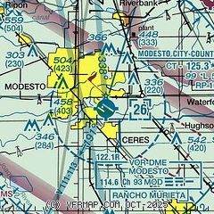
| Sectional chart |
|---|
|
 Download PDF
of official airport diagram from the FAA
| Airport distance calculator |
|---|
|
|
| Sunrise and sunset |
|---|
|
Times for 11-Jun-2026
| | Local
(UTC-7) | | Zulu
(UTC) |
|---|
| Morning civil twilight | | 05:12 | | 12:12 |
| Sunrise | | 05:43 | | 12:43 |
| Sunset | | 20:24 | | 03:24 |
| Evening civil twilight | | 20:55 | | 03:55 |
|
| Current date and time |
|---|
| Zulu (UTC) | 12-Jun-2026 02:53:22 |
|---|
| Local (UTC-7) | 11-Jun-2026 19:53:22 |
|---|
|
| METAR |
|---|
| KMOD | 120153Z 32010KT 10SM CLR 36/11 A2971 RMK AO2 SLP060 T03610111
|
KSCK
20nm NW | 120155Z 31007KT 10SM CLR 37/06 A2972 RMK AO2 SLP062 T03720056
|
|
| TAF |
|---|
| KMOD | 111720Z 1118/1218 32010KT P6SM SKC FM120600 VRB05KT P6SM SKC
|
KSCK
20nm NW | 111720Z 1118/1218 31009G18KT P6SM SKC FM112100 31008KT P6SM SKC FM120700 VRB05KT P6SM SKC
|
|
| NOTAMs |
|---|
NOTAMs are issued by the DoD/FAA and will open in a separate window not controlled by AirNav.
|
|


