FAA INFORMATION EFFECTIVE 22 JANUARY 2026
Location
| FAA Identifier: | NFG |
| Lat/Long: | 33-18-04.5300N 117-21-18.6100W
33-18.075500N 117-21.310167W
33.3012583,-117.3551694
(estimated) |
| Elevation: | 77.6 ft. / 24 m (estimated) |
| Variation: | 13E (2000) |
| From city: | 6 miles N of OCEANSIDE, CA |
| Time zone: | UTC -8 (UTC -7 during Daylight Saving Time) |
| Zip code: | 92054 |
Airport Operations
| Airport use: | Private use. Permission required prior to landing |
| Activation date: | 12/1945 |
| Control tower: | yes |
| ARTCC: | LOS ANGELES CENTER |
| FSS: | SAN DIEGO FLIGHT SERVICE STATION |
| NOTAMs facility: | NFG (NOTAM-D service available) |
| Attendance: | FRI 1600-0100Z++, ALL MON-THUR 1600-0800Z
CLSD SAT, SUN AND HOL. FREQ OPR HR MOD AND NGT EXER RY RSTD, CK BY CALLING MCAS FLT CLNC AT 760-725-8016. MCAS FLT CLNC MANNED 1 HR PRIOR OPR HR DSN 365-8016/3804, C760-725-8016/3804. HI DENSITY TFC IN CLASS D AIRSPACE 1900-2300Z++, TENANT ACFT HAVE PRIORITY FOR LCL PAT OPR. SEE FLIP AP/1 SUPPLEMENTARY ARPT INFO. |
| Pattern altitude: | TFC PAT: RGT TFC RY 21. F/W 1100 FT, R/W 600 FT, RISING TERRAIN ALL QUAD TO 3200 FT. ALL ACFT USE LDG LGT IN TFC PAT AFTER SS AND IN IMC. |
| Segmented circle: | no |
| Lights: | PCL ON TOWER 128.775 AND 340.2. WHEN TWR CLSD, ACTVT SALSF RWY 21; PAPI RWY 03 & 21; HIRL RWY 03/21 - 128.775. |
| Beacon: | white-white-green (lighted military airport)
Operates sunset to sunrise. |
Airport Communications
| ATIS: | 285.45 |
| CAMP PENDLETON GROUND: | 134.675 360.2 [1600-0800 MON-THU, 1600-0100Z++ FRI; CLSD SAT, SUN AND HOL.] |
| CAMP PENDLETON TOWER: | 128.775 340.2 271.6 [1600-0800 MON-THU, 1600-0100Z++ FRI; CLSD SAT, SUN AND HOL.] |
| SOCAL APPROACH: | 127.3 41.95FM |
| SOCAL DEPARTURE: | 127.3 |
| CLEARANCE DELIVERY: | 134.675 271.6 |
| BASE OPS: | 279.3 |
| CLASS B: | 127.3 ;294-332 SAN BLW 7,000 FT |
| EMERG: | 121.5 243.0 |
| LEGOZ STAR: | 127.4 |
| PMSV METRO: | 342.4 344.6 |
| RANGE CTL: | 123.2 ;LONG RIFLE 310.3 ;LONG RIFLE |
| WX ASOS at OKB (5 nm S): | 127.8 (760-439-9683) |
| WX AWOS-3P at L18 (6 nm NE): | 118.425 (760-723-6073) |
| WX ASOS at CRQ (11 nm S): | PHONE 760-930-0864 |
| WX AWOS-3 at F70 (20 nm NE): | 119.025 (951-696-1018) |
- ILS/RADAR - RADAR - SEE TERMINAL FLIP FOR RADAR MINIMA.
Nearby radio navigation aids
| VOR radial/distance | | VOR name | | Freq | | Var |
|---|
| OCNr026/4.8 | | OCEANSIDE VORTAC | | 115.30 | | 15E |
| ELBr126/29.3 | | EL TORO VOR/DME | | 117.20 | | 14E |
| HDFr183/(29.7) | | HOMELAND VOR | | 112.05 | | 14E |
| MZBr333/31.8 | | MISSION BAY VORTAC | | 117.80 | | 15E |
| PDZr152/38.0 | | PARADISE VORTAC | | 112.20 | | 15E |
| RALr159/(39.5) | | RIVERSIDE VOR | | 108.60 | | 14E |
| JLIr269/39.8 | | JULIAN VORTAC | | 113.75 | | 15E |
Airport Services
Runway Information
Runway 3/21
| Dimensions: | 6005 x 221 ft. / 1830 x 67 m |
| Surface: | asphalt |
| Weight bearing capacity: | |
| Runway edge lights: | high intensity |
| RUNWAY 3 | | RUNWAY 21 |
| Latitude: | 33-17.720167N | | 33-18.430833N |
| Longitude: | 117-21.720667W | | 117-20.899500W |
| Elevation: | 60.6 ft. | | 77.4 ft. |
| Traffic pattern: | left | | right |
| Runway heading: | 031 magnetic, 044 true | | 211 magnetic, 224 true |
| Visual slope indicator: | 4-light PAPI on right (4.00 degrees glide path) | | 4-light PAPI on left (3.60 degrees glide path) |
| Approach lights: | | | SALSF |
| Runway end identifier lights: | no | | no |
| Touchdown point: | yes, no lights | | yes, no lights |
Airport Ownership and Management from official FAA records
| Ownership: | U.S. Navy |
| Owner: | US NAVY
OCEANOGRAPHIC OFC - CODE 3142
WASHINGTON, DC 20373 |
Additional Remarks
| - | MISC: WX FCST AVBL 2 HR PN. |
| - | CAUTION: NUMEROUS HAZ TO FLT/GND OPR. EXTV VFR TFC IN CLASS D AIRSPACE. HI DENSITY TFC IN CLASS D AIRSPACE 1900-2300Z++. TENANT ACFT HAVE PRIORITY FOR LCL PAT OPR. SEE FLIP AP/1 SUPPLEMENTARY ARPT INFO. |
| - | HELIPADS P1, P2, P3, P4 DIMENSIONS 137 FT BY 137 FT. E2 AND F2 DIMENSIONS 133 FT BY 133 FT. |
| - | LCL-BASED AND NON-TENANT ACFT ARE AUTH TO CONDUCT ONE CLSD FLD FULL STOP ARR AND/OR ONE CLSD FLD DEP. |
| - | FOR CD WHEN ATCT CLSD CTC SOCAL APCH AT 800-448-3724. |
| - | CAUTION: HELO SPOT P2 CLSD. DUE TO APN LOADING, RDCD WINGTIP SEPN AVBL ON TWY P FOR ACFT C-130 AND LRGR. |
| - | FUEL: J5. |
| - | TRAN ALERT: NO AMC FLEET SVC AVBL. ALCE TEAM RQR FOR ALL AMC FLT. LTD TRAN SVC, NO TIE-DOWN, OIL/LABORATORY ANALYSIS OR TRAN MAINT SVC AVBL. NO SHUTTLE SVC AVBL. ALL VIP ACFT CTC AIRFIELD OPS ON PTD 15 MIN PRIOR TO ARR. TRAN CREWS RESPONSIBLE FOR COLD RFL OF THEIR OWN ACFT AND PRVD THEIR OWN NOZZLE OPERATOR. |
| - | RSTD: HVY ACFT, FULL STOP LDG ONLY. FOR USE OF MCB RANGE FACILITIES (LZ/DZ/CAL SITE/VSTOL, ETC.) CTC MCB RANGE CON SKED DSN 365-4219/3510, C760-725-4219/3510. |
| - | NS ABTMT - AVOID OVFT MCB RANCH HOUSE LCTD 2000' NE APCH END RWY 21. |
| - | RSTD: PPR 24 HR PN EXE FOR HOT REFUL OR PAT WORK, AG AND CSTMS SVC ARE AVBL UPON REQ WITH 48 HRS NTC. MCAS FLT CLNC DSN 365-8016/8026, C760-725-8016/8026, 1600-0100Z++MON-FRI. LTD RAMP SPACE, ACFT PPR STRICTLY ENFORCED FOR ALL PAX, PARTS, CARGO AND TRAN ACFT. |
Instrument Procedures
NOTE: All procedures below are presented as PDF files. If you need a reader for these files, you should download the free Adobe Reader.NOT FOR NAVIGATION. Please procure official charts for flight.
FAA instrument procedures published for use from 22 January 2026 at 0901Z to 19 February 2026 at 0900z.
STARs - Standard Terminal Arrivals |
|---|
| LEGOZ FOUR (RNAV) | |
2 pages:
[1] [2] (438KB) |
IAPs - Instrument Approach Procedures |
|---|
| RNAV (GPS) RWY 21 **CHANGED** | |
download (97KB) |
| VOR/DME OR TACAN Y RWY 21 | |
download (157KB) |
| TACAN RWY 03 | |
download (154KB) |
| TACAN Z RWY 21 | |
download (160KB) |
| COPTER TACAN RWY 21 | |
download (115KB) |
| Radar Approach Procedures available **CHANGED** | |
download (164KB) |
|
|---|
| BULLDOG THREE (OBSTACLE) | |
download (98KB) |
| CORRI FOUR (OBSTACLE) | |
download (87KB) |
| MUNN FOUR (OBSTACLE) | |
download (80KB) |
| QUNTN TWO (OBSTACLE) | |
download (76KB) |
| NOTE: Special Take-Off Minimums/Departure Procedures apply | |
download (355KB) |
Other nearby airports with instrument procedures:
KOKB - Bob Maxwell Memorial Airfield (5 nm S)
L18 - Fallbrook Community Airpark (6 nm NE)
KCRQ - Mc Clellan-Palomar Airport (11 nm S)
F70 - French Valley Airport (20 nm NE)
KRNM - Ramona Airport (27 nm SE)
|
|

Road maps at:
MapQuest
Bing
Google
| Aerial photo |
|---|

|
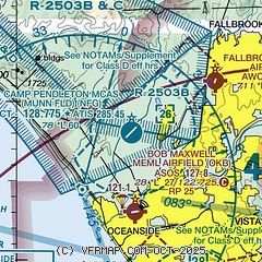
| Sectional chart |
|---|
|
 Download PDF
of official airport diagram from the FAA
| Airport distance calculator |
|---|
|
|
| Sunrise and sunset |
|---|
|
Times for 12-Feb-2026
| | Local
(UTC-8) | | Zulu
(UTC) |
|---|
| Morning civil twilight | | 06:12 | | 14:12 |
| Sunrise | | 06:37 | | 14:37 |
| Sunset | | 17:30 | | 01:30 |
| Evening civil twilight | | 17:56 | | 01:56 |
|
| Current date and time |
|---|
| Zulu (UTC) | 12-Feb-2026 10:45:49 |
|---|
| Local (UTC-8) | 12-Feb-2026 02:45:49 |
|---|
|
| METAR |
|---|
KNFG
2nm SE | 121039Z AUTO 35003KT 1 3/4SM BR CLR 08/08 A3016 RMK AO2 T00780078 $
|
KOKB
5nm S | 121026Z AUTO 00000KT 4SM BR FEW007 10/10 A3016 RMK AO2 T01000100
|
KL18
6nm NE | 121035Z AUTO 36005KT 10SM CLR 10/10 A3017 RMK AO2
|
KCRQ
11nm S | 120953Z AUTO 00000KT 10SM CLR 12/11 A3016 RMK AO2 SLP212 T01170106
|
KF70
20nm NE | 121035Z AUTO 00000KT 10SM OVC022 09/09 A3017 RMK AO2
|
|
| TAF |
|---|
KNFG
2nm SE | 1203/1303 VRB05KT 9999 SCT020 BKN030 QNH3012INS BECMG 1205/1207 6000 BR BKN020 OVC030 QNH3015INS TEMPO 1209/1215 1600 BR OVC009 FM121500 VRB05KT 3200 BR SCT020 QNH3017INS BECMG 1216/1218 25007KT 9999 NSW OVC120 641208 QNH3018INS BECMG 1218/1220 25007G17KT OVC120 641208 QNH3007INS FM130200 27005KT 9999 OVC120 541208 QNH3007INS TX19/1221Z TN07/1214Z
|
KCRQ
11nm S | 120520Z 1206/1306 VRB03KT P6SM SCT025 SCT250 FM122000 28008KT P6SM BKN250 FM130200 VRB03KT P6SM BKN250
|
|
| NOTAMs |
|---|
NOTAMs are issued by the DoD/FAA and will open in a separate window not controlled by AirNav.
|
|


