FAA INFORMATION EFFECTIVE 09 JULY 2026
Location
| FAA Identifier: | NGP |
| Lat/Long: | 27-41-33.7240N 097-17-25.3636W
27-41.562067N 097-17.422727W
27.6927011,-97.2903788
(estimated) |
| Elevation: | 18.4 ft. / 5.6 m (surveyed) |
| Variation: | 03E (2020) |
| From city: | 6 miles SE of CORPUS CHRISTI, TX |
| Time zone: | UTC -5 (UTC -6 during Standard Time) |
| Zip code: | 78418 |
Airport Operations
| Airport use: | Private use. Permission required prior to landing |
| Activation date: | 07/1943 |
| Control tower: | yes |
| ARTCC: | HOUSTON CENTER |
| FSS: | SAN ANGELO FLIGHT SERVICE STATION |
| NOTAMs facility: | NGP (NOTAM-D service available) |
| Attendance: | FRI 1300-0100Z++, ALL MON-THU 1300-0500Z++
CLSD SAT, SUN & HOL. (DT 1200-0400Z MON-THU; 1200-2400Z FRI; CLSD SAT, SUN & HOL); OT CK NOTAM. |
| Segmented circle: | no |
| Lights: | DUSK-DAWN. WHEN TWR CLSD ACTVT PCL - CTAF. |
| Beacon: | white-white-green (lighted military airport)
Operates sunset to sunrise. |
Airport Communications
| CTAF: | 134.85 |
| ATIS: | 127.9 290.9 |
| NAVY CORPUS GROUND: | 118.7 257.85 [1300-0500Z++ MON-THU; 1300-0100Z++ FRI; CLSD SAT, SUN & HOL.] |
| NAVY CORPUS TOWER: | 125.525 ;SOUTH 134.85 ;NORTH 340.2 ;NORTH 360.2 ;SOUTH [1300-0500Z++ MON-THU; 1300-0100Z++ FRI; CLSD SAT, SUN & HOL.] |
| CORPUS APPROACH: | 120.9 ;ALL RWY EXCEPT AS NOTED, HI-T 127.5 ;HI-TACAN RWY 31L 128.675 |
| CORPUS DEPARTURE: | 128.675 |
| CLEARANCE DELIVERY: | 314.3 |
| AIR: | 3123X 381.8X 5696X 8984X |
| EMERG: | 121.5 243.0 |
| OPS: | 139.0 ;ARMY OPS X-RAY CHARLIE 339.7 ;ARMY OPS X-RAY CHARLIE 49.7 ;ARMY OPS X-RAY CHARLIE |
| PMSV METRO: | 343.5 |
| SFA: | 284.6 |
| WX ASOS at CRP (12 nm NW): | PHONE 361-267-5360 |
| WX AWOS-3 at RAS (13 nm NE): | 118.425 (361-749-0537) |
| WX AWOS-3 at TFP (14 nm N): | 118.775 (361-758-8961) |
- FREQ: AIR 11201X.
- NO NOTAM MP: PAR THURS 1300-1800++.
- FREQ 343.5 RADAR WX ADVSY SVC.
Nearby radio navigation aids
| VOR radial/distance | | VOR name | | Freq | | Var |
|---|
| CRPr138/15.1 | | CORPUS CHRISTI VORTAC | | 115.50 | | 09E |
| ALIr088/(38.9) | | ALICE VOR | | 114.50 | | 06E |
Airport Services
| Bottled oxygen: | HIGH/LOW |
| Bulk oxygen: | HIGH/LOW |
Runway Information
Runway 13L/31R
| Dimensions: | 5002 x 220 ft. / 1525 x 67 m |
| Surface: | asphalt |
| Weight bearing capacity: | |
| Runway edge lights: | high intensity |
| RUNWAY 13L | | RUNWAY 31R |
| Latitude: | 27-41.717828N | | 27-41.134330N |
| Longitude: | 097-17.532007W | | 097-16.875922W |
| Elevation: | 12.9 ft. | | 17.5 ft. |
| Traffic pattern: | left | | right |
| Runway heading: | 131 magnetic, 134 true | | 311 magnetic, 314 true |
| Markings: | nonprecision, in good condition | | precision, in good condition |
| Visual slope indicator: | 4-light PAPI on left (3.00 degrees glide path) | | 4-light PAPI on left (3.00 degrees glide path) |
| Runway end identifier lights: | yes | | yes |
| Touchdown point: | yes, no lights | | yes, no lights |
Runway 18/36
| Dimensions: | 5002 x 196 ft. / 1525 x 60 m |
| Surface: | asphalt |
| Weight bearing capacity: | |
| Runway edge lights: | high intensity |
| RUNWAY 18 | | RUNWAY 36 |
| Latitude: | 27-41.953287N | | 27-41.127787N |
| Longitude: | 097-17.308767W | | 097-17.308465W |
| Elevation: | 12.5 ft. | | 16.6 ft. |
| Traffic pattern: | right | | left |
| Runway heading: | 176 magnetic, 179 true | | 356 magnetic, 359 true |
| Markings: | precision, in good condition | | precision, in good condition |
| Visual slope indicator: | 4-light PAPI on left (3.00 degrees glide path) | | 4-light PAPI on left (3.00 degrees glide path) |
| Runway end identifier lights: | yes | | yes |
| Touchdown point: | yes, no lights | | yes, no lights |
Runway 4/22
| Dimensions: | 5001 x 200 ft. / 1524 x 61 m |
| Surface: | asphalt |
| Weight bearing capacity: | |
| Runway edge lights: | high intensity |
| RUNWAY 4 | | RUNWAY 22 |
| Latitude: | 27-41.403297N | | 27-41.986570N |
| Longitude: | 097-17.846525W | | 097-17.190462W |
| Elevation: | 16.8 ft. | | 12.9 ft. |
| Traffic pattern: | left | | right |
| Runway heading: | 042 magnetic, 045 true | | 222 magnetic, 225 true |
| Markings: | precision, in good condition | | precision, in good condition |
| Visual slope indicator: | 4-light PAPI on right (3.00 degrees glide path) | | 4-light PAPI on right (3.00 degrees glide path) |
| Runway end identifier lights: | yes | | yes |
| Touchdown point: | yes, no lights | | yes, no lights |
Runway 13R/31L
| Dimensions: | 8001 x 200 ft. / 2439 x 61 m |
| Surface: | PEM |
| Weight bearing capacity: | |
| Runway edge lights: | high intensity |
| Operational restrictions: | CLSD SUN 1400-1800Z++ |
| RUNWAY 13R | | RUNWAY 31L |
| Latitude: | 27-42.044157N | | 27-41.110835N |
| Longitude: | 097-18.095635W | | 097-17.046328W |
| Elevation: | 9.4 ft. | | 16.8 ft. |
| Traffic pattern: | right | | left |
| Runway heading: | 131 magnetic, 134 true | | 311 magnetic, 314 true |
| Markings: | precision, in good condition | | precision, in good condition |
| Visual slope indicator: | 4-light PAPI on left (3.00 degrees glide path) | | 4-light PAPI on left (3.00 degrees glide path) |
| Approach lights: | SALSF | | |
| Runway end identifier lights: | no | | yes |
| Touchdown point: | yes, no lights | | yes, no lights |
| Instrument approach: | ILS/DME | | |
Airport Ownership and Management from official FAA records
| Ownership: | U.S. Navy |
| Owner: | US NAVY
OCEANOGRAPHIC OFC-CODE 3142
WASHINGTON, DC 20373 |
| Manager: | COMMANDING OFFICER/AIRFIELD OPS
NAVAL AIR STATION
CORPUS CHRISTI, TX 78419
Phone 361-961-3395
/2506. |
Additional Remarks
| - | A: ALL R/W AND F/W ACFT LDG/TAXIING TO SEAWALL PPR DSN 861-2506/2507 C361-961-2506/2507. |
| - | A: AVOID FLT OVER POPULATED AREAS BLW 1000' AGL PRIOR TO GULF SHORE LINE. |
| - | TFC PAT: TRAN ACFT EXP APCH TO FULL STOP LDG ONLY WHEN SINGLE RWY OPR ARE BEING CONDUCTED, PRACTICE APCH NOT AUTH. |
| - | CAUTION: HI MID-AIR POTENTIAL, EXTREME VIGILANCE RQR. EXER EXTREME CAUTION VCNTY WALDRON FLD NALF LCTD 3 NM S. |
| - | BEARING STRENGTH RWY 13L/31R: ST175 SBTT542 TRT585. |
| - | JASU: 3(MSU-200, A/UA47A-5), MEPP- 2(NC-8), 3(NC-10), 2(AM32A-108). |
| - | FUEL: F-24. |
| - | FLUID: SP PRESAIR LOX LHOXRB. |
| - | OIL: MIL-PRF-23699 (NATO: 0-156) AND MIL-PRF-7808 L GRADE 3 (NATO: 0-148). |
| - | CAUTION: EXTV R/W TEST FLTS CONDUCTED MON-SAT FM TOWN OF PORT O'CONNOR TO MUSTANG BEACH ARPT (KRAS), ALG THE COAST FM 300 - 5000 FT. |
| - | RSTD: REFUEL/TRAN ALERT ARNG STRONGLY RECOMMENDED FOR ALL ACFT TO AVOID EXTV SVCG/TURNAROUND DELAYS OR PRK IN HI FOD RISK AREAS. |
| - | CSTMS/AG/IMG CSTMS, IMG AVBL FOR ACFT ARRIVING FROM OVERSEAS, PLAN ARR FROM BTN 1400-2100Z-, C361-961-2506/2507.. PILOTS RQR TO PROVIDE IDENTA-PLATE NR TO INSPECTOR FOR BILLING. |
| - | A: R/W ACFT DESTINED FOR CORPUS CHRISTI ARMY DEPOT TURN IN WILL REMAIN AT LEAST 1/4 NM OFF SHORE AND 500' PRIOR TO CTC NAVY CORPUS TWR. PPR ALL CCAD TRAN ACFT. TURN IN WILL ONLY BE ACCEPTED DUR NML DUTY HR, 1300-2300Z++ MON-FRI. MON-FRI. |
| - | A: R/W ACFT MAKE APCH TO HELIPAD ADJ HNGR 44, CTC OPS/ X-RAY CHARLIE AND GND TAXI TO/FROM PARKING. POC AVN DIV, HNGR 44. |
| - | A: AVOID OVFT OF BLDG S OF RAMP AREA AND AMMO DUMP E OF CONTAINMENT AREA. |
| - | A: ALL ACFT WITH WEAPONS ARR CCAD AFTER NML DUTY HR NOTIFY CCAD SECURITY DSN 861-3313/3314, C361-961-3313/3314. |
| - | A: MAJ MAINT AVBL. |
| - | A: LOADING/UNLOADING OF AIR CARGO - MIL/CIV DESIGNATED FOR CCAD WILL BE SCHED FOR DAYLGT HR ONLY. |
| - | CAUTION: BIRD ACTIVITY/BASH - SEE AP-1. |
| - | CAUTION: IF EQUIPPED, ALL ACFT SHALL UTILIZE UHF ATC FREQS UNLESS ASSIGNED VHF. |
| - | CAUTION: NMRS BIRDS VCNTY AFLD, USE EXTREME CTN DURG HVY RAIN EVENTS. |
| - | MISC: CLSD TWR OPS: DEPARTING IFR ACFT SHALL OBTAIN AN IFR CLNC AND RELEASE FROM SAN ANGELO FSS PRIOR TO TKOF WHEN THE FIELD IS IFR VIA GROUND LINK OR CORPUS CHRISTI APCH BY CALLING 361-299-4230. IF THE FIELD IS VFR, A VFR DEPARTURE IS AUTHORIZED. |
| - | RSTD: ACFT ARR/DEP PROHIBITED ONE HR PRIOR TO AFLD OPENING DUE TO AFLD PREPARATIONS EXC FOR CUST/BORDER PROTECTION. MSN CRITICAL OR OTR EVENT RQR CTC AFM C361-961-2506/2507/5511. |
| - | MISC: ACFT OPERATING TO THE SEA WALL USE CAUTION. INBD HELI CTC CORPUS CHRISTI ARMY DEPOT (CCAD) FLT OPS X-RAY CHARLIE AT 49.70, 139.0, 339.7, OR DSN 861-0520/1020, C361-961-0520/1020. |
| - | RSTD: PPR 48 HR ALL TRAN ACFT, DSN 861-2506/2507, C361-961-2506/2507. FOR CIV AIR LDG PMT INFO CTC AFM C361-961-2506/5511. |
| - | RMK: AFM HR 1230-0500Z++ MON-THU; 1230-0100Z++ FRI; CLSD SAT, SUN AND HOL. |
| - | TWY Y OPEN FM INTXN OF RWY 04/22 TO APCH END RWY 13R. |
| - | SERVICE - FLUID - LO) AVBL ONLY WITH 7 DAYS PN OF RQMNT. |
| - | MAIN PRKG APRON FM TWY A TO TWY C LTD TO TW4 ACFT ONLY. |
| - | SERVICE: NO LAVATORY SVCS AVBL HERE. |
| - | TFC PAT: ALL ACFT USE LDG OR TAXI LGT WHILE IN ARPT TFC AREA. |
| - | SERVICE-TRAN ALERT: TRAN ACFT EXP DELAYS FROM 0900-1400L DUE TO LTD REFUL/SVC. MAINT EXTREMELY LTD BEFORE 0900L, AFTER 1400L AND DURING NON-WORK HRS. |
Instrument Procedures
NOTE: All procedures below are presented as PDF files. If you need a reader for these files, you should download the free Adobe Reader.NOT FOR NAVIGATION. Please procure official charts for flight.
FAA instrument procedures published for use from 09 July 2026 at 0901Z to 06 August 2026 at 0900Z.
IAPs - Instrument Approach Procedures |
|---|
| ILS Z OR LOC Z RWY 13R **CHANGED** | |
download (190KB) |
| ILS Y OR RNAV (GPS) RWY 13R **CHANGED** | |
download (172KB) |
| RNAV (GPS) RWY 04 **CHANGED** | |
download (162KB) |
| RNAV (GPS) RWY 13L **CHANGED** | |
download (162KB) |
| RNAV (GPS) RWY 18 **CHANGED** | |
download (155KB) |
| RNAV (GPS) RWY 22 **CHANGED** | |
download (157KB) |
| RNAV (GPS) RWY 31L **CHANGED** | |
download (166KB) |
| RNAV (GPS) RWY 31R **CHANGED** | |
download (166KB) |
| RNAV (GPS) RWY 36 **CHANGED** | |
download (156KB) |
| VOR/DME OR TACAN Y RWY 13R **CHANGED** | |
download (163KB) |
| VOR/DME OR TACAN Y RWY 31L **CHANGED** | |
download (162KB) |
| HI-TACAN W RWY 31L **CHANGED** | |
download (197KB) |
| HI-TACAN X RWY 13R **CHANGED** | |
download (189KB) |
| TACAN RWY 18 **CHANGED** | |
download (159KB) |
| TACAN RWY 36 **CHANGED** | |
download (160KB) |
| TACAN X RWY 31L **CHANGED** | |
download (169KB) |
| TACAN Z RWY 13R **CHANGED** | |
download (166KB) |
| TACAN Z RWY 31L **CHANGED** | |
download (165KB) |
| Radar Approach Procedures available | |
download (163KB) |
| NOTE: Special Take-Off Minimums/Departure Procedures apply | |
download (299KB) |
Other nearby airports with instrument procedures:
KCRP - Corpus Christi International Airport (12 nm NW)
KRAS - Mustang Beach Airport (13 nm NE)
KTFP - Ingleside Regional Airport (14 nm N)
KRBO - Nueces County Airport (22 nm W)
T69 - Sinton Airport (25 nm NW)
|
|

Road maps at:
MapQuest
Bing
Google
| Aerial photo |
|---|
WARNING: Photo may not be current or correct
 Photo by Jack Vos
Photo taken 01-Sep-2017
looking north.
Photo by Jack Vos
Photo taken 01-Sep-2017
looking north.
Do you have a better or more recent aerial photo of Corpus Christi Naval Air Station (Truax Field) Airport that you would like to share? If so, please send us your photo.
|
| Sectional chart |
|---|
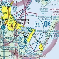
|
 Download PDF
of official airport diagram from the FAA
| Airport distance calculator |
|---|
|
|
| Sunrise and sunset |
|---|
|
Times for 28-Jul-2026
| | Local
(UTC-5) | | Zulu
(UTC) |
|---|
| Morning civil twilight | | 06:26 | | 11:26 |
| Sunrise | | 06:51 | | 11:51 |
| Sunset | | 20:20 | | 01:20 |
| Evening civil twilight | | 20:46 | | 01:46 |
|
| Current date and time |
|---|
| Zulu (UTC) | 29-Jul-2026 02:59:53 |
|---|
| Local (UTC-5) | 28-Jul-2026 21:59:53 |
|---|
|
| METAR |
|---|
| KNGP | 290156Z 15012G21KT 10SM FEW015 28/26 A2984 RMK AO2 SLP102 T02830256
|
KNWL
4nm S | 290253Z AUTO 10SM CLR 28/26 A2985 RMK AO2 SLP106 T02830256 53003 $
|
KCRP
12nm W | 290251Z 15016KT 10SM FEW017 28/25 A2984 RMK AO2 SLP101 T02830250 53002
|
KRAS
13nm NE | 290235Z AUTO 15011KT 10SM CLR 29/25 A2986 RMK AO2 T02880254
|
KTFP
14nm N | 290235Z AUTO 17013G19KT 10SM CLR 29/25 A2984 RMK AO1 T02920250
|
|
| TAF |
|---|
| KNGP | 282200Z 2823/2923 15019G27KT 9999 FEW020 510003 QNH2981INS FM290100 17013G20KT 9999 SCT015 SCT250 500000 QNH2982INS TEMPO 2909/2912 18011KT BKN015 FM291800 15020G28KT 9999 FEW025 SCT250 510003 QNH2984INS TX33/2919Z TN28/2912Z FN20081
|
KCRP
12nm W | 281720Z 2818/2918 15018G25KT P6SM FEW035 FM290400 15010KT P6SM FEW020 FM291600 16013G20KT P6SM SCT250
|
|
| NOTAMs |
|---|
NOTAMs are issued by the DoD/FAA and will open in a separate window not controlled by AirNav.
|
|


