FAA INFORMATION EFFECTIVE 19 FEBRUARY 2026
Location
| FAA Identifier: | SPK |
| Lat/Long: | 40-08-42.1000N 111-40-03.7000W
40-08.701667N 111-40.061667W
40.1450278,-111.6676944
(estimated) |
| Elevation: | 4529.5 ft. / 1381 m (estimated) |
| Variation: | 11E (2020) |
| From city: | 2 miles N of SPANISH FORK, UT |
| Time zone: | UTC -7 (UTC -6 during Daylight Saving Time) |
| Zip code: | 84660 |
Airport Operations
| Airport use: | Open to the public |
| Activation date: | 10/2017 |
| Control tower: | no |
| ARTCC: | SALT LAKE CITY CENTER |
| FSS: | CEDAR CITY FLIGHT SERVICE STATION |
| NOTAMs facility: | CDC (NOTAM-D service available) |
| Attendance: | MON-SAT 0900-1700
AFT HRS FUEL ATNDT 801-798-9888. |
| Pattern altitude: | TPA FOR FIXED WING ACFT IS 1000 FT AGL; TPA FOR ROTARY WING ACFT IS 500 FT AGL. |
| Wind indicator: | lighted |
| Segmented circle: | yes |
| Lights: | ACTVT REIL RWY 12 & 30; PAPI RWY 12 & 30; MIRL RWY 12/30 - CTAF. |
| Beacon: | white-green (lighted land airport)
Operates sunset to sunrise. |
Airport Communications
| CTAF: | 122.9 |
| WX AWOS-3PT: | 119.275 (801-804-5801) |
| SALT LAKE CITY APPROACH: | 118.85 |
| SALT LAKE CITY DEPARTURE: | 118.85 |
| WX AWOS-3PT at PVU (5 nm NW): | 135.175 (801-373-9782) |
Nearby radio navigation aids
| VOR radial/distance | | VOR name | | Freq | | Var |
|---|
| PVUr135/4.9 | | PROVO VOR/DME | | 108.40 | | 15E |
| FFUr106/14.7 | | FAIRFIELD VORTAC | | 116.60 | | 16E |
Airport Services
| Fuel available: | 100LL JET-A
100LL:SELF SVC 100LL AVBL 24 HRS.
A:FOR JET A FUEL CALL 801-798-9888. |
| Parking: | hangars and tiedowns |
| Airframe service: | MAJOR |
| Powerplant service: | MAJOR |
| Bottled oxygen: | NONE |
| Bulk oxygen: | NONE |
Runway Information
Runway 12/30
| Dimensions: | 6500 x 100 ft. / 1981 x 30 m |
| Surface: | asphalt, in good condition |
| Weight bearing capacity: | | PCN 17 /F/D/X/T | | Single wheel: | 24.0 | | Double wheel: | 36.0 |
|
| Runway edge lights: | medium intensity |
| RUNWAY 12 | | RUNWAY 30 |
| Latitude: | 40-09.062175N | | 40-08.341028N |
| Longitude: | 111-40.576700W | | 111-39.546085W |
| Elevation: | 4523.9 ft. | | 4528.8 ft. |
| Traffic pattern: | left | | left |
| Runway heading: | 121 magnetic, 132 true | | 301 magnetic, 312 true |
| Markings: | nonprecision, in poor condition | | nonprecision, in poor condition |
| Visual slope indicator: | 4-light PAPI on left (3.00 degrees glide path) | | 4-light PAPI on left (3.00 degrees glide path) |
| Runway end identifier lights: | yes | | yes |
| Touchdown point: | yes, no lights | | yes, no lights |
| Obstructions: | none | | 16 ft. road, 350 ft. from runway, 20:1 slope to clear |
Airport Ownership and Management from official FAA records
| Ownership: | Publicly-owned |
| Owner: | SPANISH FORK
2050 NORTH 300 WEST
SPANISH FORK, UT 84660
Phone 801-798-5000 |
| Manager: | CHRISTIAN DAVIS
2050 NORTH 300 WEST
SPANISH FORK, UT 84660
Phone 801-804-4593 |
Additional Remarks
| - | FOR CD CTC SALT LAKE CITY APCH AT 801-325-9670. |
| - | COLD TEMPERATURE AIRPORT. ALTITUDE CORRECTION REQUIRED AT OR BELOW -17C. |
| - | RWY 12 APCH, 60 FT MKD/LGTD PLINE, 1475 FT DSTC, 0 FT BOTH, APCH SLOPE 21:1. |
| - | LNDG FEES IN EFCT FOR ALL ACFT. |
Instrument Procedures
NOTE: All procedures below are presented as PDF files. If you need a reader for these files, you should download the free Adobe Reader.NOT FOR NAVIGATION. Please procure official charts for flight.
FAA instrument procedures published for use from 19 February 2026 at 0901Z to 19 March 2026 at 0900Z.
STARs - Standard Terminal Arrivals |
|---|
| TAYTR TWO (RNAV) | |
2 pages:
[1] [2] (256KB) |
IAPs - Instrument Approach Procedures |
|---|
| RNAV (GPS) RWY 12 **NEW** | |
download (400KB) |
| RNAV (GPS)-A | |
download (301KB) |
|
|---|
| SPANISH FORK ONE (OBSTACLE) | |
2 pages:
[1] [2] (461KB) |
| NOTE: Special Take-Off Minimums/Departure Procedures apply | |
download (357KB) |
Other nearby airports with instrument procedures:
KPVU - Provo Municipal Airport (5 nm NW)
KHCR - Heber Valley Airport (23 nm NE)
U14 - Nephi Municipal Airport (26 nm S)
KSVR - South Valley Regional Airport (32 nm NW)
KSLC - Salt Lake City International Airport (41 nm N)
|
|

Road maps at:
MapQuest
Bing
Google
| Aerial photo |
|---|
WARNING: Photo may not be current or correct
 Taken in the Summer of 2018
looking north.
Taken in the Summer of 2018
looking north.
Do you have a better or more recent aerial photo of Spanish Fork Municipal Airport/Woodhouse Field that you would like to share? If so, please send us your photo.
|
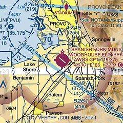
| Sectional chart |
|---|
|
CAUTION: Diagram may not be current

| Airport distance calculator |
|---|
|
|
| Sunrise and sunset |
|---|
|
Times for 13-Mar-2026
| | Local
(UTC-6) | | Zulu
(UTC) |
|---|
| Morning civil twilight | | 07:15 | | 13:15 |
| Sunrise | | 07:42 | | 13:42 |
| Sunset | | 19:30 | | 01:30 |
| Evening civil twilight | | 19:57 | | 01:57 |
|
| Current date and time |
|---|
| Zulu (UTC) | 14-Mar-2026 00:42:25 |
|---|
| Local (UTC-6) | 13-Mar-2026 18:42:25 |
|---|
|
| METAR |
|---|
| KSPK | 140015Z AUTO 25008G13KT 10SM CLR 20/M07 A3003 RMK AO2
|
KPVU
5nm NW | 132356Z 21005KT 10SM CLR 19/M06 A3004 RMK AO2 SLP152 6//// T01941056 10211 20161 56017 PNO $
|
|
| TAF |
|---|
KPVU
5nm NW | 131738Z 1318/1418 VRB05KT P6SM FEW200 FM132000 28007KT P6SM FEW150 FEW200 FM140300 VRB05KT P6SM BKN150
|
|
| NOTAMs |
|---|
NOTAMs are issued by the DoD/FAA and will open in a separate window not controlled by AirNav.
|
|


