FAA INFORMATION EFFECTIVE 14 MAY 2026
Location
| FAA Identifier: | SZL |
| Lat/Long: | 38-43-49.1000N 093-32-52.3100W
38-43.818333N 093-32.871833W
38.7303056,-93.5478639
(estimated) |
| Elevation: | 871 ft. / 265.5 m (surveyed) |
| Variation: | 01E (2015) |
| From city: | 2 miles S of KNOB NOSTER, MO |
| Time zone: | UTC -5 (UTC -6 during Standard Time) |
| Zip code: | 65305 |
Airport Operations
| Airport use: | Private use. Permission required prior to landing |
| Control tower: | yes |
| ARTCC: | KANSAS CITY CENTER |
| FSS: | COLUMBIA FLIGHT SERVICE STATION |
| NOTAMs facility: | COU (NOTAM-D service available) |
| Attendance: | CONTINUOUS |
| Pattern altitude: | TPA RECTANGULAR 1900 FT, COPTER 1400 FT, OVERHEAD 2400 FT. |
| Wind indicator: | yes |
| Segmented circle: | no |
| Beacon: | white-green (lighted land airport)
Operates sunset to sunrise. |
Airport Communications
| ATIS: | 118.725 239.025 |
| WHITEMAN GROUND: | 119.125 275.8 [24, CLSD HOL.] |
| WHITEMAN TOWER: | 132.4 318.8 [24, CLSD HOL.] |
| WHITEMAN APPROACH: | 127.45 284.0 [OPR 1300-0500Z++ MON-FRI; 1400-2300Z++ SAT-SUN; CLSD HOL.] |
| WHITEMAN DEPARTURE: | 125.925 343.65 [OPR 1300-0500Z++ MON-FRI; 1400-2300Z++ SAT-SUN; CLSD HOL.] |
| CLEARANCE DELIVERY: | 121.75 335.8 |
| ARNG OPS: | 139.0 242.4 41.0FM 49.65 |
| COMD POST: | 311.0 321.0 |
| EMERG: | 121.5 243.0 |
| PTD: | 372.2 |
| WX AWOS-3PT at RCM (12 nm W): | 119.575 (660-422-7010) |
| WX ASOS at DMO (17 nm E): | 120.525 (660-826-8225) |
- APCH/DEP SVC PRVDD BY KANSAS CITY ARTCC ON FREQS 135.575/323.15 (KNOB NOSTER RCAG) WHEN APCH CTL CLSD.
- TA13 REMOTE BRIEFING SVC AVBL THRU KANSAS CITY METRO ON FREQ 369.9.
- 303 TFS OPS: 227.8
- REMARKS: CALL GROUND HOG.
- ASR: NO-NOTAM MP 0700-1300Z++ MON, TUE.
Nearby radio navigation aids
| VOR radial/distance | | VOR name | | Freq | | Var |
|---|
| ANXr122/34.9 | | NAPOLEON VORTAC | | 115.15 | | 07E |
Airport Services
| Airframe service: | MAJOR |
| Powerplant service: | MAJOR |
| Bottled oxygen: | NONE |
| Bulk oxygen: | LOW |
Runway Information
Runway 1/19
| Dimensions: | 12400 x 150 ft. / 3780 x 46 m |
| Surface: | concrete, in good condition |
| Weight bearing capacity: | |
| Runway edge lights: | high intensity |
| Operational restrictions: | ADDL WT BRG CPTY: ST175 TDT800 |
| RUNWAY 1 | | RUNWAY 19 |
| Latitude: | 38-42.815500N | | 38-44.821333N |
| Longitude: | 093-33.118833W | | 093-32.624833W |
| Elevation: | 837.4 ft. | | 870.5 ft. |
| Traffic pattern: | left | | left |
| Markings: | precision, in good condition | | precision, in good condition |
| Visual slope indicator: | 4-light PAPI on left (2.86 degrees glide path)
RSTRD 5 DEGS LEFT OR RIGHT OF RWY CNTRLN. | | 4-light PAPI on left (3.00 degrees glide path) |
| RVR equipment: | touchdown, rollout | | touchdown, rollout |
| Approach lights: | ALSF1: standard 2,400 foot high intensity approach lighting system with centerline sequenced flashers (category I) | | ALSF1: standard 2,400 foot high intensity approach lighting system with centerline sequenced flashers (category I) |
| Runway end identifier lights: | no | | no |
| Touchdown point: | yes, no lights | | yes, no lights |
| Instrument approach: | ILS | | LOC/GS |
Airport Ownership and Management from official FAA records
| Ownership: | U.S. Air Force |
| Owner: | USAF
WHITEMAN AFB
SEDALIA, MO 65301 |
| Manager: | BASE COMMANDER
WHITEMAN AFB
SEDALIA, MO 65301
Phone 660-687-6185 |
Additional Remarks
| - | RWY LOAD CAPACITY: TRT585 |
| - | JASU: 2(A/M32A-86D) 1(AM32-95) |
| - | FUEL: A, A++, A++100. |
| - | FLUID: LPOX |
| - | OIL: SOAP |
| - | TRAN ALERT: OPR 1400-0400Z++ MON-THU; 1400-0300Z++ FRI; 1400-2300Z++ WKEND, CLSD HOL. LTD DE-ICING OF TRAN ACFT AVBL. FLEET SVC NOT AVBL. |
| - | RSTD: PPR FOR ALL TRAN ACFT, RQR APVL FR AFLD MGMT, DSN 975-3101 C660-687-3101, 48 HR PRIOR. ISSUED PPR VAILD 1 HR PRIOR/AFTER ETA. LATE/EARLY ARR/DEP MUST BE RE-COORD. B52 OPS RQR COORD WITH AFLD MGMT. PPR FOR ALL TRAN ACFT, RQR APVL FR AFLD MGMT, DSN 975-3101 C660-687-3101, 48 HR PRIOR. ISSUED PPR VAILD 1 HR PRIOR/AFTER ETA. LATE/EARLY ARR/DEP MUST BE RE-COORD. B52 OPS RQR COORD WITH AFLD MGMT. B52 RWY ACCESS LTD TO TWY D. NO OVFT WEAPONS STOR AREA LCTD ESE OF RWY AND CITY OF KNOB NOSTER LCTD 1.5 NM NNW OF FLD. |
| - | RSTD: ACFT WITH VIP CTC AFLD MGMT 30 MIN PRIOR TO LDG. CTC TWR 10 MIN PRIOR TO LDG. |
| - | CAUTION: 112 FT AGL TWR 4000 FT DIRECTLY WEST ABEAM RWY O1 THLD. POSSIBLE ILLUSION OF BEING HI ON FINAL DUR NGT VFR APCH TO RWY 01. |
| - | CAUTION: LCL ACFT FLY 300 KT IN OVERHEAD PAT. BIRD WATCH COND CHG RAPIDLY. BIRD AIRCRAFT STRIKE HAZARD (BASH) DISPERSAL METHODS USED INCL PYROTECHNICS AND PROPANE CANNON. CTC ATIS, TWR OR PTD FOR CURRENT BIRD HAZ INFO. |
| - | TFC PAT: COPTER 1400 FT; RECTANGULAR 1900 FT; OVERHEAD 2400 FT. |
| - | MISC: AFLD MGMT DSN 975-3101, C660-687-3101, FAX 660-687-2343. |
| - | ARNG: OPR 1300-2100Z++ MON; 1300-0400Z++ TUE-THURS; 1300-2100Z++ FRI; CLSD WKEND AND HOL. SEE NOTAMS FOR MOST UP TO DATE OPR HR, DSN 975-5768. |
| - | TRAN ALERT: TRANSIENT SVC AVBL FOR F16 ACFT, EXCEPT THE SENSOR CHIP INSPECTION UNAVBL. |
| - | MISC: WX OBS VIS RESTRICTIONS: DIRECT VIEW OF THE RY IS BLOCKED BY THE B-2 MAINT DOCKS. VIS IS FURTHER RESTRICTED BY BLDG 33 N ON W SIDE OF FLT LINE. |
| - | CAUTION: PHASE I REPRESENTS NORMAL BIRD ACTIVITY OUTSIDE MIGRATORY SEASON. PHASE II REPRESENTS HEAVY BIRD ACTIVITY; NORMALLY ASSOCIATED WITH MIGRATORY SEASON. THE PHASE II TIMEFRAME AT WHITEMAN IS FM 1 APR - 30 MAY (SPRING MIGTRATION) & 15 SEP - 30 NOV (FALL MIGRATION). |
| - | 20 FT POLE 185 FT SOUTH OF TWY 'C' EAST. |
| - | MISC: DUR NOTAM SNOW REMOVAL OPR OR FCST WX EVENTS CTC AFLD MGMT DSN 975-3101 C660-687-3101 FOR MOST CURRENT AFLD STATUS. |
| - | MISC: WHEN AFLD CLSD RSC/RCR UNAVBL. |
| - | WHEN APP/DEP CLSD CTC GND. |
| - | MISC: ARFF CAPABILITIES AT PERM REDUCED LVL OF SVC FOR NFPA 403 CAT 9 (E-4, KC-10, VC-25 (747)) & CAT 10 (C-5) ACFT. |
| - | WX SVC AVBL H24 EXC DUR APVD HOL DSN 975-3062, C660-687-3062. H24 SBY AVBL DUR APVD HOL AND CLOSURE. WX OPS AIRCREWS CAN RCV WX BRFG FR OPS DESK DSN 975-3062, C660-687-3062. AFLD WX MNT BY AN/FMQ-19 ASOS AND AUGMENTED BY HUMAN OBSERVER ONLY DUR INDCD HR OF OPR. |
| - | RSTD: PPRS WILL NOT BE GIVEN MORE THAN 7 DAYS PRIOR. |
| - | CAUTION: FUEL TANKS BTN HANGER 6 AND HANGER 7 DO NOT HAVE OBSTRUCTION LIGHTS |
| - | EXTRMLY LTD DE-ICG CPBLTYS. COORD DE-ICG REQ THRU TSNT MAINT. DE-ICG TRUCK BOOM UNA TO RCH C-5 OR C-17 TAIL. C-5 AND C-17 AIRCREWS MUST BRING DE-ICG TAIL ADAPTER TO BE ABLE TO DE-ICE TAIL OF ACFT. |
| - | PMSV UNAVBL. ACFT IN NEED OF WX SUPPORT CTC 509 OSS/OSW VIA FONE PATCH 975-3061, C660-687-3061, OR 509 BW/CP 975-3778, C660-687-3778. |
| - | NO CNTRLN MRK ON COMPASS ROSE/ALTN HAZ CARGO PAD. |
| - | TACAN GCP TWY C E OF RWY UNUSE. |
| - | CAUTION - OBSTRUCTION LIGHT OUT OF SERVICE ON THE FOLLOWING FACILITIES: BUILDING 117, HARDSTAND 3 BALLPARK LIGHT FIXTURE, BUILDING 52, BUILDING 91, BALLPARK LIGHT FIXTURES ABEAM HANGAR 91, BUILDING 1155, BUILDING 1162, BUILDING 1163 AND THE A-10 SUNSHADES. OBSTRUCTION LIGHT ON COMMUNICATIONS TOWER IS WHITE AND NOT RED. |
Instrument Procedures
NOTE: All procedures below are presented as PDF files. If you need a reader for these files, you should download the free Adobe Reader.NOT FOR NAVIGATION. Please procure official charts for flight.
FAA instrument procedures published for use from 14 May 2026 at 0901Z to 11 June 2026 at 0900Z.
IAPs - Instrument Approach Procedures |
|---|
| HI-ILS OR LOC Z RWY 01 | |
download (145KB) |
| HI-ILS OR LOC Z RWY 19 | |
download (154KB) |
| ILS OR LOC Y RWY 01 | |
download (79KB) |
| ILS OR LOC Y RWY 19 | |
download (135KB) |
| RNAV (GPS) RWY 01 | |
download (64KB) |
| RNAV (GPS) RWY 19 | |
download (61KB) |
| HI-TACAN Z RWY 01 | |
download (129KB) |
| HI-TACAN Z RWY 19 | |
download (143KB) |
| TACAN Y RWY 01 | |
download (69KB) |
| TACAN Y RWY 19 | |
download (71KB) |
| Radar Approach Procedures available | |
download (146KB) |
| NOTE: Special Take-Off Minimums/Departure Procedures apply | |
download (234KB) |
Other nearby airports with instrument procedures:
KRCM - Skyhaven Airport (12 nm W)
KDMO - Sedalia Regional Airport (17 nm E)
KHIG - Higginsville Industrial Municipal Airport (21 nm N)
KGLY - Clinton Regional Airport (23 nm S)
KRAW - Warsaw Municipal Airport (25 nm SE)
|
|

Road maps at:
MapQuest
Bing
Google
| Aerial photo |
|---|
WARNING: Photo may not be current or correct
 Photo by John Wieland
Photo taken 14-Jul-2008
from a C182.
Photo by John Wieland
Photo taken 14-Jul-2008
from a C182.
Do you have a better or more recent aerial photo of Whiteman Air Force Base that you would like to share? If so, please send us your photo.
|
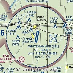
| Sectional chart |
|---|
|
 Download PDF
of official airport diagram from the FAA
| Airport distance calculator |
|---|
|
|
| Sunrise and sunset |
|---|
|
Times for 04-Jun-2026
| | Local
(UTC-5) | | Zulu
(UTC) |
|---|
| Morning civil twilight | | 05:20 | | 10:20 |
| Sunrise | | 05:51 | | 10:51 |
| Sunset | | 20:34 | | 01:34 |
| Evening civil twilight | | 21:05 | | 02:05 |
|
| Current date and time |
|---|
| Zulu (UTC) | 05-Jun-2026 00:49:42 |
|---|
| Local (UTC-5) | 04-Jun-2026 19:49:42 |
|---|
|
| METAR |
|---|
| KSZL | 042355Z 17011KT 10SM FEW040 SCT120 27/21 A2994 RMK AO2A DZB10E28 SLP135 P0000 60000 T02730211 10300 20262 57012 $
|
KRCM
12nm W | 050035Z AUTO 15008KT 10SM CLR 25/20 A2993 RMK AO2
|
|
| TAF |
|---|
| KSZL | 042235Z 0422/0601 19012G18KT 9999 BKN050 QNH2992INS TEMPO 0423/0424 4800 -TSRA OVC050CB BECMG 0501/0502 17009KT 9999 FEW050 QNH2992INS BECMG 0505/0506 19012G20KT 9999 BKN015 520052 QNH2989INS TEMPO 0509/0512 4800 -SHRA OVC015 BECMG 0513/0514 22015G25KT 9999 BKN020 QNH2990INS BECMG 0517/0518 22012G18KT 9999 BKN040 QNH2983INS TX28/0422Z TN19/0511Z
|
|
| NOTAMs |
|---|
NOTAMs are issued by the DoD/FAA and will open in a separate window not controlled by AirNav.
|
|


