FAA INFORMATION EFFECTIVE 16 APRIL 2026
Location
| FAA Identifier: | VIH |
| Lat/Long: | 38-07-38.7460N 091-46-10.2500W
38-07.645767N 091-46.170833W
38.1274294,-91.7695139
(estimated) |
| Elevation: | 1147.8 ft. / 349.8 m (surveyed) |
| Variation: | 02E (2000) |
| From city: | 11 miles N of central business district of the associated city |
| Time zone: | UTC -5 (UTC -6 during Standard Time) |
| Zip code: | 65580 |
Airport Operations
| Airport use: | Open to the public |
| Activation date: | 02/1944 |
| Control tower: | no |
| ARTCC: | KANSAS CITY CENTER |
| FSS: | COLUMBIA FLIGHT SERVICE STATION |
| NOTAMs facility: | VIH (NOTAM-D service available) |
| Attendance: | MON-FRI 0600-1700, ALL SAT-SUN 0800-1600 |
| Wind indicator: | lighted |
| Segmented circle: | no |
| Lights: | ACTVT PAPI RWY 04; VASI RWY 22; MIRL RWY 04/22 AND RWY 13/31 - CTAF. |
| Beacon: | white-green (lighted land airport)
Operates sunset to sunrise. |
Airport Communications
| CTAF/UNICOM: | 123.0 |
| WX ASOS: | 119.025 (573-299-4419) |
- APCH/DEP SVC PRVDD BY KANSAS CITY ARTCC ON FREQS 128.35/284.675 (MAPLES RCAG).
Nearby radio navigation aids
| VOR radial/distance | | VOR name | | Freq | | Var |
|---|
| VIHr236/3.4 | | VICHY VOR/DME | | 117.70 | | 06E |
| TBNr037/(29.0) | | FORNEY VOR | | 110.00 | | 00E |
| SHYr082/39.7 | | SUNSHINE VOR/DME | | 108.40 | | 00E |
Airport Services
| Fuel available: | 100LL JET-A |
| Parking: | tiedowns |
| Airframe service: | MINOR
AIRFRAME & PWR PLANT RPRS EMERG ONLY. |
| Powerplant service: | MINOR |
| Bottled oxygen: | NONE |
| Bulk oxygen: | NONE |
Runway Information
Runway 13/31
| Dimensions: | 5501 x 100 ft. / 1677 x 30 m |
| Surface: | asphalt, in fair condition |
| Weight bearing capacity: | | Single wheel: | 48.0 | | Double wheel: | 62.0 | | Double tandem: | 92.0 |
|
| Runway edge lights: | medium intensity |
| RUNWAY 13 | | RUNWAY 31 |
| Latitude: | 38-07.820578N | | 38-07.162720N |
| Longitude: | 091-46.552982W | | 091-45.763865W |
| Elevation: | 1136.5 ft. | | 1147.8 ft. |
| Traffic pattern: | left | | left |
| Runway heading: | 135 magnetic, 137 true | | 315 magnetic, 317 true |
| Markings: | basic, in fair condition | | basic, in fair condition |
| Touchdown point: | yes, no lights | | yes, no lights |
Runway 4/22
| Dimensions: | 5500 x 100 ft. / 1676 x 30 m |
| Surface: | asphalt, in excellent condition |
| Weight bearing capacity: | | Single wheel: | 75.0 | | Double wheel: | 85.0 | | Double tandem: | 130.0 |
|
| Runway edge lights: | medium intensity |
| RUNWAY 4 | | RUNWAY 22 |
| Latitude: | 38-07.488367N | | 38-08.111385N |
| Longitude: | 091-46.599743W | | 091-45.766753W |
| Elevation: | 1137.1 ft. | | 1109.1 ft. |
| Traffic pattern: | left | | left |
| Runway heading: | 045 magnetic, 047 true | | 225 magnetic, 227 true |
| Displaced threshold: | 211 ft. | | no |
| Markings: | nonprecision, in good condition | | nonprecision, in fair condition |
| Visual slope indicator: | 4-light PAPI on left (3.00 degrees glide path) | | 4-box VASI on left (3.00 degrees glide path) |
| Runway end identifier lights: | no | | no |
| Touchdown point: | yes, no lights | | yes, no lights |
| Obstructions: | 20 ft. road, 435 ft. from runway, 270 ft. left and right of centerline, 11:1 slope to clear
APCH RATIO TO DSPLCD THLD 29:1; DSPLCD THLD 1 FT LOWER THAN RY END. | | none |
Airport Ownership and Management from official FAA records
| Ownership: | Publicly-owned |
| Owner: | CITY OF ROLLA
901 N. ELM ST., PO BOX 979
ROLLA, MO 65401
Phone 573-426-6948 |
| Manager: | DARRIN BACON
631 AIRPORT DRIVE
VICHY, MO 65580
Phone 573-299-4498 |
Additional Remarks
| - | 144 FT WATER TOWER LCTD 2000 FT NNE OF RWY 13 THLD. |
| - | RADIO CONTROLLED MODEL AIRPLANES INVOF ARPT. |
| - | HELI PARKING ON SE CORNER OF APRON. |
| - | WILDLIFE ON & INVOF ARPT. |
| - | 270 FT ANTENNA TOWER 1.5 MILES SE OF RWY 31 THLD |
| - | CLSD RWY UNUSBL AS TWY. |
| - | FOR CD IF UNA TO CTC ON FSS FREQ, CTC KANSAS CITY ARTCC AT 913-254-8508. |
Instrument Procedures
NOTE: All procedures below are presented as PDF files. If you need a reader for these files, you should download the free Adobe Reader.NOT FOR NAVIGATION. Please procure official charts for flight.
FAA instrument procedures published for use from 16 April 2026 at 0901Z to 14 May 2026 at 0900Z.
IAPs - Instrument Approach Procedures |
|---|
| RNAV (GPS) RWY 04 | |
download (220KB) |
| RNAV (GPS) RWY 22 | |
download (209KB) |
| VOR/DME RWY 04 | |
download (190KB) |
| VOR RWY 22 | |
download (183KB) |
| NOTE: Special Alternate Minimums apply | |
download (133KB) |
| NOTE: Special Take-Off Minimums/Departure Procedures apply | |
download (421KB) |
Other nearby airports with instrument procedures:
KUBX - Cuba Municipal Airport (16 nm E)
KTBN - Waynesville-St. Robert Regional Airport-Forney Field (29 nm SW)
KUUV - Sullivan Regional Airport (29 nm E)
K33 - Salem Memorial Airport (32 nm S)
KJEF - Jefferson City Memorial Airport (33 nm NW)
|
|

Road maps at:
MapQuest
Bing
Google
| Aerial photo |
|---|
WARNING: Photo may not be current or correct
 Photo by L D Pahnke.
Photo taken 25-Jun-2009
looking southwest at 5500.
Photo by L D Pahnke.
Photo taken 25-Jun-2009
looking southwest at 5500.
Do you have a better or more recent aerial photo of Rolla National Airport that you would like to share? If so, please send us your photo.
|
| Sectional chart |
|---|
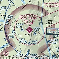
|
| Airport distance calculator |
|---|
|
|
| Sunrise and sunset |
|---|
|
Times for 24-Apr-2026
| | Local
(UTC-5) | | Zulu
(UTC) |
|---|
| Morning civil twilight | | 05:52 | | 10:52 |
| Sunrise | | 06:20 | | 11:20 |
| Sunset | | 19:50 | | 00:50 |
| Evening civil twilight | | 20:18 | | 01:18 |
|
| Current date and time |
|---|
| Zulu (UTC) | 24-Apr-2026 06:17:23 |
|---|
| Local (UTC-5) | 24-Apr-2026 01:17:23 |
|---|
|
| METAR |
|---|
| KVIH | 240553Z AUTO 22008KT 10SM SCT029 BKN039 OVC049 20/16 A2977 RMK AO2 RAE11 SLP072 P0000 60000 T02000161 10217 20200 402670139 53009
|
|
| TAF |
|---|
KTBN
30nm SW | 232100Z 2321/2503 18015G25KT 9999 BKN038 BKN060 QNH2973INS BECMG 2400/2401 18012G18KT 9999 SCT060 QNH2971INS BECMG 2407/2408 31012KT 9000 -SHRA VCTS BKN019CB OVC035 QNH2976INS TEMPO 2408/2410 VRB20G30KT 4800 TSRA BKN011CB OVC020 BECMG 2413/2414 26009KT 9999 NSW FEW020 SCT060 BKN150 QNH2975INS BECMG 2421/2422 03006KT 9999 FEW150 QNH2977INS TX26/2321Z TN14/2413Z LAST NO AMDS AFT 2403 NEXT 2413
|
KJEF
34nm NW | 240520Z 2406/2506 21010G20KT 4SM -SHRA OVC050 PROB30 2406/2408 29020G35KT 1SM +TSRA OVC035CB FM240900 20006KT 6SM -SHRA OVC040 FM241200 27008KT P6SM SCT025 BKN040 FM241800 32007KT P6SM BKN250
|
|
| NOTAMs |
|---|
NOTAMs are issued by the DoD/FAA and will open in a separate window not controlled by AirNav.
|
|

