FAA INFORMATION EFFECTIVE 14 MAY 2026
Location
| FAA Identifier: | LIT |
| Lat/Long: | 34-43-45.9890N 092-13-29.1980W
34-43.766483N 092-13.486633W
34.7294414,-92.2247772
(estimated) |
| Elevation: | 266 ft. / 81.1 m (surveyed) |
| Variation: | 00E (2020) |
| From city: | 2 miles E of LITTLE ROCK, AR |
| Time zone: | UTC -5 (UTC -6 during Standard Time) |
| Zip code: | 72202 |
Airport Operations
| Airport use: | Open to the public |
| Activation date: | 04/1940 |
| Control tower: | yes |
| ARTCC: | MEMPHIS CENTER |
| FSS: | JONESBORO FLIGHT SERVICE STATION |
| NOTAMs facility: | LIT (NOTAM-D service available) |
| Attendance: | CONTINUOUS |
| Wind indicator: | lighted |
| Segmented circle: | no |
| Lights: | SS-SR |
| Beacon: | white-green (lighted land airport)
Operates sunset to sunrise. |
| Landing fee: | yes |
| Fire and rescue: | ARFF index C |
| International operations: | customs landing rights airport |
Airport Communications
| UNICOM: | 122.95 |
| WX ASOS: | PHONE 501-376-0247 |
| ADAMS GROUND: | 121.9 339.8 |
| ADAMS TOWER: | 118.7 257.8 |
| LITTLE ROCK APPROACH: | 119.5 ;240-039 135.4 ;040-239 291.775 306.2 ;240-039 353.6 ;040-239 |
| LITTLE ROCK DEPARTURE: | 119.5 ;240-039 135.4 ;040-239 306.2 ;240-039 353.6 ;040-239 |
| CLEARANCE DELIVERY: | 118.95 |
| PRE-TAXI CLEARANCE: | 118.95 |
| CLASS C: | 119.5 ;240-039 135.4 ;040-239 306.2 ;240-039 353.6 ;040-239 |
| D-ATIS: | 125.65 |
| EMERG: | 121.5 243.0 |
| IC: | 135.4 ;040-239 353.6 ;040-239 |
| WX AWOS-3PT at ORK (6 nm N): | 123.775 (501-906-6529) |
| WX AWOS-3 at SUZ (15 nm SW): | 132.125 (501-847-3883) |
Nearby radio navigation aids
| VOR radial/distance | | VOR name | | Freq | | Var |
|---|
| LITr217/6.0 | | LITTLE ROCK VORTAC | | 115.10 | | 00W |
| PBFr329/32.5 | | PINE BLUFF VOR/DME | | 116.00 | | 04E |
Airport Services
| Fuel available: | 100LL JET-A |
| Parking: | hangars and tiedowns |
| Airframe service: | MAJOR |
| Powerplant service: | MAJOR |
| Bottled oxygen: | HIGH |
| Bulk oxygen: | HIGH |
Runway Information
Runway 4L/22R
| Dimensions: | 8273 x 150 ft. / 2522 x 46 m |
| Surface: | concrete/grooved, in good condition |
| Weight bearing capacity: | | Single wheel: | 75.0 | | Double wheel: | 200.0 | | Double tandem: | 350.0 |
|
| Runway edge lights: | high intensity |
| RUNWAY 4L | | RUNWAY 22R |
| Latitude: | 34-43.350742N | | 34-44.289273N |
| Longitude: | 092-14.281402W | | 092-13.082950W |
| Elevation: | 253.0 ft. | | 261.5 ft. |
| Traffic pattern: | left | | right |
| Runway heading: | 047 | | 227 |
| Displaced threshold: | 297 ft. | | no |
| Declared distances: | TORA:8273 TODA:8273 ASDA:8273 LDA:7976 | | TORA:8273 TODA:8273 ASDA:8273 LDA:8273 |
| Markings: | precision, in good condition | | precision, in good condition |
| Visual slope indicator: | 4-light PAPI on left (3.00 degrees glide path) | | 4-light PAPI on right (3.00 degrees glide path) |
| RVR equipment: | touchdown, midfield, rollout | | touchdown, midfield, rollout |
| Approach lights: | MALSR: 1,400 foot medium intensity approach lighting system with runway alignment indicator lights | | ALSF2: standard 2,400 foot high intensity approach lighting system with centerline sequenced flashers (category II or III) |
| Runway end identifier lights: | no | | |
| Centerline lights: | yes | | yes |
| Touchdown point: | yes, no lights | | yes, lighted |
| Instrument approach: | ILS/DME | | ILS/DME |
| Obstructions: | 23 ft. rr, lighted, 670 ft. from runway, 557 ft. left of centerline, 20:1 slope to clear
APCH RATIO 42:1 FM DSPLCD THLD. | | none |
Runway 4R/22L
| Dimensions: | 8251 x 150 ft. / 2515 x 46 m |
| Surface: | concrete/grooved, in good condition |
| Weight bearing capacity: | | Single wheel: | 75.0 | | Double wheel: | 200.0 | | Double tandem: | 350.0 |
|
| Runway edge lights: | high intensity |
| RUNWAY 4R | | RUNWAY 22L |
| Latitude: | 34-43.163190N | | 34-44.099113N |
| Longitude: | 092-13.273163W | | 092-12.077712W |
| Elevation: | 266.0 ft. | | 259.4 ft. |
| Traffic pattern: | right | | left |
| Runway heading: | 047 | | 227 |
| Displaced threshold: | 1050 ft. | | no |
| Declared distances: | TORA:8250 TODA:8250 ASDA:8250 LDA:7200 | | TORA:7200 TODA:7200 ASDA:7200 LDA:7200 |
| Markings: | precision, in good condition | | precision, in good condition |
| Visual slope indicator: | 4-light PAPI on right (3.00 degrees glide path) | | 4-light PAPI on left (3.00 degrees glide path) |
| RVR equipment: | touchdown, rollout | | touchdown, rollout |
| Approach lights: | MALSR: 1,400 foot medium intensity approach lighting system with runway alignment indicator lights | | MALSF: 1,400 foot medium intensity approach lighting system with sequenced flashers |
| Centerline lights: | yes | | yes |
| Touchdown point: | yes, no lights | | yes, no lights |
| Instrument approach: | ILS/DME | | ILS/DME |
| Obstructions: | 78 ft. pole, lighted, 2874 ft. from runway, 820 ft. right of centerline, 34:1 slope to clear | | 72 ft. trees, 3301 ft. from runway, 754 ft. right of centerline, 43:1 slope to clear |
Runway 18/36
| Dimensions: | 6224 x 150 ft. / 1897 x 46 m |
| Surface: | concrete/grooved, in good condition |
| Weight bearing capacity: | | Single wheel: | 75.0 | | Double wheel: | 100.0 | | Double tandem: | 135.0 |
|
| Runway edge lights: | medium intensity |
| RUNWAY 18 | | RUNWAY 36 |
| Latitude: | 34-44.387407N | | 34-43.361745N |
| Longitude: | 092-14.285655W | | 092-14.318392W |
| Elevation: | 258.9 ft. | | 253.3 ft. |
| Traffic pattern: | left | | left |
| Runway heading: | 182 | | 002 |
| Displaced threshold: | no | | 164 ft. |
| Declared distances: | TORA:6060 TODA:6060 ASDA:6060 LDA:6060 | | TORA:6224 TODA:6224 ASDA:6224 LDA:6060 |
| Markings: | nonprecision, in good condition | | nonprecision, in good condition |
| Visual slope indicator: | 4-light PAPI on left (3.00 degrees glide path) | | 4-light PAPI on right (3.75 degrees glide path) |
| Touchdown point: | yes, no lights | | yes, no lights |
| Obstructions: | 35 ft. tree, 1286 ft. from runway, 164 ft. left of centerline, 31:1 slope to clear
APCH RATIO 39:1 BASED ON DSPLCD THLD +35 FT TREE 1385 FT DIST 164 FT LEFT. | | 105 ft. trees, 2489 ft. from runway, 351 ft. right of centerline, 21:1 slope to clear
APCH RATIO 24:1 BASED ON DSPLCD THLD; 105 FT TREES 2579 FT DIST 351 FT R. |
Airport Ownership and Management from official FAA records
| Ownership: | Publicly-owned |
| Owner: | CITY OF LITTLE ROCK
1 AIRPORT DRIVE
LITTLE ROCK, AR 72202
Phone 501-372-3439 |
| Manager: | DAVID TIPTON
1 AIRPORT DRIVE
LITTLE ROCK, AR 72202
Phone 501-537-7311 |
Additional Remarks
| A39-18/36 | PCR VALUE: 347/R/B/W/T |
| A39-04R/22L | PCR VALUE: 719/R/A/W/T |
| A39-04L/22R | PCR VALUE: 865/R/B/W/T |
| E60-22R | ENGINEERED MATERIALS ARRESTING SYSTEM (EMAS) 262.6 FT IN LENGTH BY 169.7 FT IN WIDTH LCTD AT THE DER 22R. |
| - | LARGE CONCENTRATIONS OF BIRDS INVOF ARPT; MOST ACTIVITY BTN SR-SS UP TO 1500 FT MSL. |
| - | FOR CD WHEN UNA VIA FREQ CTC LITTLE ROCK APCH 501-379-2908 OR LITTLE ROCK ATCT 501-379-2911. |
| - | SMGCS SUSPENDED UFN. |
| - | PSGR ACR ACFT ADG-IV AND HYR RESTRICTED FROM USING TWY F BTN TWY E AND ATLANTIC AVN/ENVOY HNGR RAMP DUE TO NON-STD SAFETY AREA |
| - | CARGO & TERMINAL RAMPS ARE NON-MOVEMENT AREAS. |
| - | NO GENERAL AVIATION PARKING ON TERMINAL OR CARGO RAMP. |
| - | TWY A 315 FT SOUTH OF TWY A6 INTERSECTION TO RWY 36 CLSD EXCEPT ACFT WITH WINGSPAN LESS THAN 79 FT. |
| - | BE ALERT: NORTH LITTLE ROCK MUNI AIRPORT IS LCTD 6 MILES NNW WITH SIMILAR RUNWAY CONFIGURATIONS. |
Instrument Procedures
NOTE: All procedures below are presented as PDF files. If you need a reader for these files, you should download the free Adobe Reader.NOT FOR NAVIGATION. Please procure official charts for flight.
FAA instrument procedures published for use from 14 May 2026 at 0901Z to 11 June 2026 at 0900Z.
IAPs - Instrument Approach Procedures |
|---|
| ILS OR LOC RWY 04L | |
download (315KB) |
| ILS OR LOC RWY 04R | |
download (333KB) |
| ILS OR LOC RWY 22L | |
download (316KB) |
| ILS OR LOC RWY 22R | |
download (297KB) |
| ILS RWY 22R (SA CAT I) | |
download (237KB) |
| ILS RWY 22R (CAT II - III) | |
download (237KB) |
| RNAV (GPS) RWY 04L | |
download (310KB) |
| RNAV (GPS) RWY 04R | |
download (290KB) |
| RNAV (GPS) RWY 18 | |
download (249KB) |
| RNAV (GPS) RWY 22L | |
download (264KB) |
| RNAV (GPS) RWY 22R | |
download (230KB) |
| RNAV (GPS) RWY 36 | |
download (234KB) |
| NOTE: Special Alternate Minimums apply | |
download (144KB) |
| NOTE: Special Take-Off Minimums/Departure Procedures apply | |
download (388KB) |
Other nearby airports with instrument procedures:
KORK - North Little Rock Municipal Airport (6 nm N)
KLRF - Little Rock Air Force Base (12 nm N)
KSUZ - Saline County Regional Airport (15 nm SW)
KCXW - Conway Regional Airport (24 nm NW)
9M8 - Sheridan-Grant County Regional Airport (25 nm S)
|
|

Road maps at:
MapQuest
Bing
Google
| Aerial photo |
|---|
WARNING: Photo may not be current or correct
 Photo by Vicki Eifert
Taken in the Spring of 2017
looking northwest.
Photo by Vicki Eifert
Taken in the Spring of 2017
looking northwest.
Do you have a better or more recent aerial photo of Bill and Hillary Clinton National Airport/Adams Field that you would like to share? If so, please send us your photo.
|
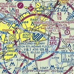
| Sectional chart |
|---|
|
CAUTION: Diagram may not be current
 Download PDF
of official airport diagram from the FAA
| Airport distance calculator |
|---|
|
|
| Sunrise and sunset |
|---|
|
Times for 19-May-2026
| | Local
(UTC-5) | | Zulu
(UTC) |
|---|
| Morning civil twilight | | 05:36 | | 10:36 |
| Sunrise | | 06:04 | | 11:04 |
| Sunset | | 20:07 | | 01:07 |
| Evening civil twilight | | 20:35 | | 01:35 |
|
| Current date and time |
|---|
| Zulu (UTC) | 19-May-2026 07:07:11 |
|---|
| Local (UTC-5) | 19-May-2026 02:07:11 |
|---|
|
| METAR |
|---|
| KLIT | 190653Z 19009KT 9SM CLR 24/20 A2999 RMK AO2 SLP155 T02440200
|
KORK
6nm N | 190655Z AUTO 18009KT 10SM SCT034 BKN048 OVC055 24/20 A3000 RMK AO2
|
KLRF
12nm N | 190555Z AUTO 16004KT 10SM CLR 24/21 A2999 RMK AO2 SLP155 T02400205 10280 20234 402990234 50015
|
KSUZ
15nm SW | 190655Z AUTO 18006KT 8SM OVC055 23/22 A2999 RMK A01
|
|
| TAF |
|---|
| KLIT | 190520Z 1906/2006 18008KT P6SM BKN150 WS020/18045KT FM191200 18011KT P6SM VCSH OVC025 FM191800 21011G19KT 3SM -TSRA BR OVC025CB FM192200 28012KT P6SM -RA OVC050 FM200300 36004KT 4SM BR VCSH OVC050
|
KLRF
12nm N | 182300Z 1823/2005 18009KT 9999 SCT150 QNH2994INS BECMG 1902/1903 16012KT 9999 SCT200 QNH2996INS BECMG 1911/1912 19010G15KT 9999 BKN020 QNH3006INS BECMG 1914/1915 19010G22KT 9999 SCT040 QNH2997INS BECMG 1918/1919 28010G18KT 6000 SHRA VCTS OVC050CB QNH3005INS TEMPO 1920/1923 4800 -TSRA OVC020CB BECMG 1923/1924 17009KT 8000 BR BKN050 QNH3006INS TX31/1921Z TN23/1911Z
|
|
| NOTAMs |
|---|
NOTAMs are issued by the DoD/FAA and will open in a separate window not controlled by AirNav.
|
|


