FAA INFORMATION EFFECTIVE 16 APRIL 2026
Location
| FAA Identifier: | ORK |
| Lat/Long: | 34-49-59.3000N 092-15-14.9000W
34-49.988333N 092-15.248333W
34.8331389,-92.2541389
(estimated) |
| Elevation: | 545.4 ft. / 166.2 m (surveyed) |
| Variation: | 02E (2000) |
| From city: | 4 miles N of NORTH LITTLE ROCK, AR |
| Time zone: | UTC -5 (UTC -6 during Standard Time) |
| Zip code: | 72120 |
Airport Operations
| Airport use: | Open to the public |
| Activation date: | 02/1957 |
| Control tower: | no |
| ARTCC: | MEMPHIS CENTER |
| FSS: | JONESBORO FLIGHT SERVICE STATION |
| NOTAMs facility: | JBR (NOTAM-D service available) |
| Attendance: | 0600-2000 |
| Pattern altitude: | 1545.4 ft. MSL
TPA FOR HELS 500 FT AGL, PROP ACFT 1000 FT AGL, TURBOPROP ACFT 1500 FT AGL |
| Wind indicator: | lighted |
| Segmented circle: | yes |
| Lights: | ACTVT REIL RWYS 05, 23, 17; MIRL RWYS 05/23 & 17/35 - CTAF. PAPI RWYS 05, 23, 17 & 35 OPR CONSLY. |
| Beacon: | white-green (lighted land airport)
Operates sunset to sunrise. |
Airport Communications
| CTAF/UNICOM: | 123.075 |
| WX AWOS-3PT: | 123.775 (501-906-6529) |
| LITTLE ROCK APPROACH: | 119.5 |
| LITTLE ROCK DEPARTURE: | 119.5 |
| CLEARANCE DELIVERY: | 121.6 |
| WX ASOS at LIT (6 nm S): | PHONE 501-376-0247 |
| WX AWOS-3 at SUZ (18 nm SW): | 132.125 (501-847-3883) |
| WX AWOS-2 at CXW (19 nm NW): | 118.775 (501-358-6209) |
Nearby radio navigation aids
| VOR radial/distance | | VOR name | | Freq | | Var |
|---|
| LITr285/5.2 | | LITTLE ROCK VORTAC | | 115.10 | | 00W |
| PBFr331/38.7 | | PINE BLUFF VOR/DME | | 116.00 | | 04E |
Airport Services
| Fuel available: | 100LL JET-A
100LL:100LL AVBL 24 HR SELF SERVICE WITH CREDIT CARD. |
| Parking: | tiedowns |
| Airframe service: | MAJOR |
| Powerplant service: | MAJOR |
| Bottled oxygen: | NONE |
| Bulk oxygen: | NONE |
Runway Information
Runway 5/23
| Dimensions: | 5002 x 75 ft. / 1525 x 23 m |
| Surface: | concrete, in good condition |
| Weight bearing capacity: | | Single wheel: | 30.0 | | Double wheel: | 60.0 |
|
| Runway edge lights: | medium intensity |
| RUNWAY 5 | | RUNWAY 23 |
| Latitude: | 34-49.713895N | | 34-50.185058N |
| Longitude: | 092-15.540997W | | 092-14.720287W |
| Elevation: | 541.2 ft. | | 518.0 ft. |
| Traffic pattern: | left | | right |
| Runway heading: | 053 magnetic, 055 true | | 233 magnetic, 235 true |
| Markings: | precision, in good condition | | nonprecision, in good condition |
| Visual slope indicator: | 2-light PAPI on right (3.00 degrees glide path) | | 2-light PAPI on left (3.00 degrees glide path) |
| Runway end identifier lights: | yes | | yes |
| Touchdown point: | yes, no lights | | yes, no lights |
| Instrument approach: | LOC/DME | | |
| Obstructions: | 16 ft. trees, 950 ft. from runway, 100 ft. right of centerline, 46:1 slope to clear | | none |
Runway 17/35
| Dimensions: | 3019 x 75 ft. / 920 x 23 m |
| Surface: | asphalt, in fair condition |
| Weight bearing capacity: | |
| Runway edge lights: | medium intensity |
| RUNWAY 17 | | RUNWAY 35 |
| Latitude: | 34-50.301203N | | 34-49.803515N |
| Longitude: | 092-15.446077W | | 092-15.442418W |
| Elevation: | 544.1 ft. | | 541.1 ft. |
| Traffic pattern: | right | | left
CALM WIND PREFERRED TKOF/LNDG TO THE NORTH WHEN POSSIBLE. |
| Runway heading: | 178 magnetic, 180 true | | 358 magnetic, 360 true |
| Markings: | nonprecision, in fair condition | | nonprecision, in fair condition |
| Visual slope indicator: | 2-light PAPI on left (3.00 degrees glide path) | | 2-light PAPI on left (3.00 degrees glide path) |
| Runway end identifier lights: | yes | | |
| Touchdown point: | yes, no lights | | yes, no lights |
| Obstructions: | 12 ft. gnd, 200 ft. from runway, 200 ft. left of centerline
+12 FT BERM 100 FT FM RY END 200 FT L & R OF CNTRLN EXTENDED INTO PRIMARY SFC. | | 26 ft. trees, 1100 ft. from runway, 34:1 slope to clear |
Airport Ownership and Management from official FAA records
| Ownership: | Publicly-owned |
| Owner: | CITY OF NORTH LITTLE ROCK
PO BOX 5757
NORTH LITTLE ROCK, AR 72119
Phone 501-340-5302 |
| Manager: | VIRGINIA YOUNG
8240 REMOUNT ROAD
NORTH LITTLE ROCK, AR 72118
Phone 501-835-5654 |
Additional Remarks
| - | FOR CD WHEN UNA VIA FREQ CTC LITTLE ROCK APCH 501-379-2908 OR LITTLE ROCK ATCT 501-379-2911 |
| - | RY 23 THLD NOT VISIBLE FM RY 17 THLD. |
| - | DEER ON & INVOF ARPT. |
| - | RY 17/35 500 FT BLAST PAD NORTH END. |
| - | FOR ARPT ACCESS CALL 501-835-5654; 501-529-1051 |
| - | ULTRALIGHT ACTIVITY ON & INVOF ARPT. |
Instrument Procedures
NOTE: All procedures below are presented as PDF files. If you need a reader for these files, you should download the free Adobe Reader.NOT FOR NAVIGATION. Please procure official charts for flight.
FAA instrument procedures published for use from 16 April 2026 at 0901Z to 14 May 2026 at 0900Z.
IAPs - Instrument Approach Procedures |
|---|
| RNAV (GPS) RWY 05 | |
download (242KB) |
| RNAV (GPS) RWY 35 | |
download (215KB) |
| LOC RWY 05 | |
download (245KB) |
| NOTE: Special Alternate Minimums apply | |
download (121KB) |
| NOTE: Special Take-Off Minimums/Departure Procedures apply | |
download (322KB) |
Other nearby airports with instrument procedures:
KLIT - Bill and Hillary Clinton National Airport/Adams Field (6 nm S)
KLRF - Little Rock Air Force Base (7 nm NE)
KSUZ - Saline County Regional Airport (18 nm SW)
KCXW - Conway Regional Airport (19 nm NW)
4M3 - Carlisle Municipal Airport (27 nm E)
|
|

Road maps at:
MapQuest
Bing
Google
| Aerial photo |
|---|
WARNING: Photo may not be current or correct
 Photo courtesy of the Arkansas Department of Aeronautics
Taken in the Spring of 2007
Photo courtesy of the Arkansas Department of Aeronautics
Taken in the Spring of 2007
Do you have a better or more recent aerial photo of North Little Rock Municipal Airport that you would like to share? If so, please send us your photo.
|
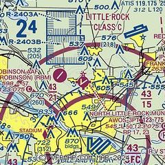
| Sectional chart |
|---|
|
| Airport distance calculator |
|---|
|
|
| Sunrise and sunset |
|---|
|
Times for 22-Apr-2026
| | Local
(UTC-5) | | Zulu
(UTC) |
|---|
| Morning civil twilight | | 06:03 | | 11:03 |
| Sunrise | | 06:30 | | 11:30 |
| Sunset | | 19:46 | | 00:46 |
| Evening civil twilight | | 20:12 | | 01:12 |
|
| Current date and time |
|---|
| Zulu (UTC) | 22-Apr-2026 19:34:28 |
|---|
| Local (UTC-5) | 22-Apr-2026 14:34:28 |
|---|
|
| METAR |
|---|
| KORK | 221915Z AUTO 18007KT 9SM OVC043 22/15 A3010 RMK AO2
|
KLIT
6nm S | 221853Z 24005KT 9SM FEW028 OVC049 22/14 A3011 RMK AO2 SLP197 T02220144
|
KLRF
7nm NE | 221855Z AUTO 21005KT 10SM OVC042 23/15 A3010 RMK AO2 SLP195 T02250148
|
KSUZ
18nm SW | 221915Z AUTO VRB06G12KT 4SM HZ BKN055 24/17 A3009 RMK A01
|
KCXW
19nm NW | 221915Z AUTO 15010KT 9SM OVC033 23/20 A3009 RMK A01
|
|
| TAF |
|---|
KLIT
6nm S | 221720Z 2218/2318 17007KT P6SM BKN050 FM222100 15007KT P6SM BKN080 BKN250 FM230000 15004KT P6SM FEW250 FM230600 16003KT P6SM BKN100 FM231200 17004KT 5SM BR BKN040 FM231500 19011KT P6SM BKN060
|
KLRF
7nm NE | 221500Z 2215/2321 17009KT 9000 -SHRA BKN035 OVC060 QNH3011INS BECMG 2217/2218 18012KT 8000 -SHRA OVC035 QNH3003INS BECMG 2222/2223 17009KT 9999 NSW SCT050 QNH2997INS BECMG 2314/2315 18010G18KT 9999 BKN035 QNH2994INS TX27/2222Z TN15/2310Z
|
|
| NOTAMs |
|---|
NOTAMs are issued by the DoD/FAA and will open in a separate window not controlled by AirNav.
|
|


