FAA INFORMATION EFFECTIVE 12 JUNE 2025
Location
| FAA Identifier: | LVS |
| Lat/Long: | 35-39-15.2000N 105-08-32.6000W
35-39.253333N 105-08.543333W
35.6542222,-105.1423889
(estimated) |
| Elevation: | 6877.2 ft. / 2096.2 m (surveyed) |
| Variation: | 13E (1965) |
| From city: | 5 miles NE of LAS VEGAS, NM |
| Time zone: | UTC -6 (UTC -7 during Standard Time) |
| Zip code: | 87701 |
Airport Operations
| Airport use: | Open to the public |
| Activation date: | 12/1946 |
| Control tower: | no |
| ARTCC: | ALBUQUERQUE CENTER |
| FSS: | ALBUQUERQUE FLIGHT SERVICE STATION |
| NOTAMs facility: | LVS (NOTAM-D service available) |
| Attendance: | MON-FRI 0800-1630
IF UNAVBL - EMERG 505-429-3198 OR 505-425-7504. |
| Wind indicator: | lighted |
| Segmented circle: | yes |
| Lights: | ACTVT PAPI RWY 02, 20, 14, 32; MIRL RWY 02/20 & 14/32 - CTAF. |
| Beacon: | white-green (lighted land airport)
Operates sunset to sunrise. |
Airport Communications
| CTAF/UNICOM: | 122.8 |
| WX ASOS: | 118.525 (505-454-4645) |
- APCH/DEP SVC PRVDD BY ALBUQUERQUE ARTCC (ZAB) ON FREQS 132.8/346.35 (SANDIA MOUNTAIN RCAG).
Nearby radio navigation aids
| VOR radial/distance | | VOR name | | Freq | | Var |
|---|
| FTI at field | | FORT UNION VORTAC | | 117.30 | | 13E |
| ACHr339/32.9 | | ANTON CHICO VORTAC | | 117.80 | | 12E |
Airport Services
| Fuel available: | 100LL JET-A1 |
| Parking: | tiedowns |
Runway Information
Runway 14/32
| Dimensions: | 8199 x 75 ft. / 2499 x 23 m |
| Surface: | asphalt, in good condition |
| Weight bearing capacity: | | PCN 7 /F/D/X/T | | Single wheel: | 20.0 |
|
| Runway edge lights: | medium intensity |
| RUNWAY 14 | | RUNWAY 32 |
| Latitude: | 35-39.858625N | | 35-38.669705N |
| Longitude: | 105-08.929568W | | 105-08.143350W |
| Elevation: | 6839.9 ft. | | 6877.2 ft. |
| Traffic pattern: | left | | left |
| Runway heading: | 139 magnetic, 152 true | | 319 magnetic, 332 true |
| Markings: | nonprecision, in fair condition | | nonprecision, in fair condition |
| Visual slope indicator: | 2-light PAPI on left (3.00 degrees glide path) | | 2-light PAPI on left (3.00 degrees glide path) |
| Touchdown point: | yes, no lights | | yes, no lights |
Runway 2/20
| Dimensions: | 5006 x 75 ft. / 1526 x 23 m |
| Surface: | asphalt, in good condition |
| Weight bearing capacity: | | PCN 8 /F/D/X/T | | Single wheel: | 20.0 |
|
| Runway edge lights: | medium intensity |
| RUNWAY 2 | | RUNWAY 20 |
| Latitude: | 35-38.895925N | | 35-39.572233N |
| Longitude: | 105-08.845510W | | 105-08.267078W |
| Elevation: | 6866.0 ft. | | 6860.5 ft. |
| Traffic pattern: | left | | left |
| Runway heading: | 022 magnetic, 035 true | | 202 magnetic, 215 true |
| Markings: | nonprecision, in good condition | | nonprecision, in good condition |
| Visual slope indicator: | 2-light PAPI on left (3.00 degrees glide path) | | 2-light PAPI on left (3.00 degrees glide path) |
| Approach lights: | ODALS: omnidirectional approach lighting system
OTS INDEFLY. | | ODALS: omnidirectional approach lighting system
OTS INDEFLY. |
| Touchdown point: | yes, no lights | | yes, no lights |
Airport Ownership and Management from official FAA records
| Ownership: | Publicly-owned |
| Owner: | CITY OF LAS VEGAS
1700 NORTH GRAND
LAS VEGAS, NM 87701
Phone 505-454-1401 |
| Manager: | JOHN ARAGON
910 AIRPORT ROAD
LAS VEGAS, NM 87701
Phone 505-454-0881 |
Additional Remarks
| - | BIRDS ON & INVOF ARPT. |
| - | NMRS HOLD & DRCTN SIGNS OTS. |
| - | FOR CD IF UNA TO CTC ON FSS FREQ, CTC ALBUQUERQUE ARTCC AT 505-856-4561. |
| - | FUEL 24 HR SELF SVC WITH CREDIT CARD. |
Instrument Procedures
NOTE: All procedures below are presented as PDF files. If you need a reader for these files, you should download the free Adobe Reader.NOT FOR NAVIGATION. Please procure official charts for flight.
FAA instrument procedures published for use from 12 June 2025 at 0901Z to 10 July 2025 at 0900z.
IAPs - Instrument Approach Procedures |
|---|
| RNAV (GPS) RWY 02 **CHANGED** | |
download (224KB) |
| RNAV (GPS) RWY 20 **CHANGED** | |
download (214KB) |
| RNAV (GPS) RWY 32 **CHANGED** | |
download (218KB) |
| VOR RWY 20 **CHANGED** | |
download (182KB) |
| NOTE: Special Alternate Minimums apply | |
download (37KB) |
| NOTE: Special Take-Off Minimums/Departure Procedures apply | |
download (105KB) |
Other nearby airports with instrument procedures:
KSAF - Santa Fe Regional Airport (46 nm W)
KAXX - Angel Fire Airport (47 nm N)
KSKX - Taos Regional Airport (54 nm NW)
KLAM - Los Alamos Airport (56 nm W)
0E0 - Moriarty Municipal Airport (58 nm SW)
|
|

Road maps at:
MapQuest
Bing
Google
| Aerial photo |
|---|
WARNING: Photo may not be current or correct
 Photo courtesy of AirNav, LLC
Photo taken 03-Jan-2016
looking northeast.
Photo courtesy of AirNav, LLC
Photo taken 03-Jan-2016
looking northeast.
Do you have a better or more recent aerial photo of Las Vegas Municipal Airport that you would like to share? If so, please send us your photo.
|
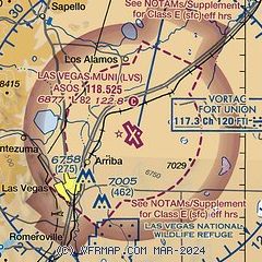
| Sectional chart |
|---|
|
| Airport distance calculator |
|---|
|
|
| Sunrise and sunset |
|---|
|
Times for 26-Jun-2025
| | Local
(UTC-6) | | Zulu
(UTC) |
|---|
| Morning civil twilight | | 05:17 | | 11:17 |
| Sunrise | | 05:47 | | 11:47 |
| Sunset | | 20:19 | | 02:19 |
| Evening civil twilight | | 20:49 | | 02:49 |
|
| Current date and time |
|---|
| Zulu (UTC) | 26-Jun-2025 15:10:49 |
|---|
| Local (UTC-6) | 26-Jun-2025 09:10:49 |
|---|
|
| METAR |
|---|
| KLVS | 261453Z AUTO 03004KT 10SM CLR 18/12 A3029 RMK AO2 SLP155 T01830122 51013 $
|
|
| TAF |
|---|
| KLVS | 261120Z 2612/2712 VRB05KT P6SM FEW110 FM261900 16013KT P6SM SCT100 PROB30 2621/2624 VRB18G31KT 6SM -TSRA BKN070CB FM270100 19011KT P6SM SCT100
|
|
| NOTAMs |
|---|
NOTAMs are issued by the DoD/FAA and will open in a separate window not controlled by AirNav.
|
|


