FAA INFORMATION EFFECTIVE 14 MAY 2026
Location
| FAA Identifier: | 0E0 |
| Lat/Long: | 34-58-41.4000N 106-00-00.1000W
34-58.690000N 106-00.001667W
34.9781667,-106.0000278
(estimated) |
| Elevation: | 6204.2 ft. / 1891.0 m (surveyed) |
| Variation: | 11E (1995) |
| From city: | 2 miles SE of MORIARTY, NM |
| Time zone: | UTC -6 (UTC -7 during Standard Time) |
| Zip code: | 87035 |
Airport Operations
| Airport use: | Open to the public |
| Activation date: | 05/1967 |
| Control tower: | no |
| ARTCC: | ALBUQUERQUE CENTER |
| FSS: | ALBUQUERQUE FLIGHT SERVICE STATION |
| NOTAMs facility: | 0E0 (NOTAM-D service available) |
| Attendance: | 0800-1700 |
| Wind indicator: | lighted |
| Segmented circle: | yes |
| Lights: | ACTVT PAPI RWY 26; MIRL RWY 08/26 - CTAF. |
| Beacon: | white-green (lighted land airport)
Operates sunset to sunrise. |
Airport Communications
| CTAF: | 122.9 |
| WX AWOS-3: | 118.05 (505-832-9379) |
- APCH/DEP SVC PRVDD BY ALBUQUERQUE ARTCC (ZAB) ON 133.65/284.6 ( CLINES CORNER RCAG).
Nearby radio navigation aids
| VOR radial/distance | | VOR name | | Freq | | Var |
|---|
| OTOr196/(6.5) | | OTTO VOR | | 114.45 | | 13E |
| SAFr162/33.9 | | SANTA FE VORTAC | | 110.60 | | 13E |
| CNXr324/40.0 | | CORONA VORTAC | | 115.50 | | 13E |
Airport Services
| Fuel available: | 100LL JET-A
100LL:100LL H24 SELF SVC WITH CREDIT CARD.
A:JET A SVC - 505-677-1122 OR 858-231-7478. |
| Parking: | tiedowns |
| Airframe service: | MAJOR |
| Powerplant service: | MAJOR |
| Bottled oxygen: | HIGH |
Runway Information
Runway 8/26
| Dimensions: | 7702 x 75 ft. / 2348 x 23 m |
| Surface: | asphalt, in excellent condition |
| Weight bearing capacity: | |
| Runway edge lights: | medium intensity |
| Operational restrictions: | RWY 26 CALM WIND RWY. |
| RUNWAY 8 | | RUNWAY 26 |
| Latitude: | 34-58.937915N | | 34-58.935440N |
| Longitude: | 106-01.074647W | | 105-59.532422W |
| Elevation: | 6204.2 ft. | | 6185.7 ft. |
| Traffic pattern: | left | | left |
| Runway heading: | 079 magnetic, 090 true | | 259 magnetic, 270 true |
| Markings: | nonprecision, in good condition | | nonprecision, in good condition |
| Visual slope indicator: | | | 2-light PAPI on left (3.00 degrees glide path) |
| Touchdown point: | yes, no lights | | yes, no lights |
Runway 17/35
| Dimensions: | 6201 x 75 ft. / 1890 x 23 m |
| Surface: | asphalt, in excellent condition |
| Weight bearing capacity: | | PCN 3 /F/D/Y/T | | Single wheel: | 30.0 | | Double wheel: | 60.0 |
|
| RUNWAY 17 | | RUNWAY 35 |
| Latitude: | 34-58.894352N | | 34-57.872503N |
| Longitude: | 105-59.624100W | | 105-59.626782W |
| Elevation: | 6187.3 ft. | | 6174.3 ft. |
| Traffic pattern: | left | | left |
| Runway heading: | 169 magnetic, 180 true | | 349 magnetic, 000 true |
| Markings: | basic, in good condition | | basic, in good condition |
| Touchdown point: | yes, no lights | | yes, no lights |
Airport Ownership and Management from official FAA records
| Ownership: | Publicly-owned |
| Owner: | CITY OF MORIARTY
PO BOX 130
MORIARTY, NM 87035
Phone 505-832-4406 |
| Manager: | BOB HUDSON
PO BOX 130
MORIARTY, NM 87035
Phone 505-832-5072
505-832-4406. |
Additional Remarks
Instrument Procedures
NOTE: All procedures below are presented as PDF files. If you need a reader for these files, you should download the free Adobe Reader.NOT FOR NAVIGATION. Please procure official charts for flight.
FAA instrument procedures published for use from 14 May 2026 at 0901Z to 11 June 2026 at 0900Z.
IAPs - Instrument Approach Procedures |
|---|
| RNAV (GPS) RWY 08 | |
download (196KB) |
| RNAV (GPS) RWY 26 | |
download (201KB) |
| NOTE: Special Take-Off Minimums/Departure Procedures apply | |
download (287KB) |
Other nearby airports with instrument procedures:
KABQ - Albuquerque International Sunport Airport (30 nm W)
KSAF - Santa Fe Regional Airport (39 nm N)
KAEG - Double Eagle II Airport (40 nm W)
KBRG - Belen Regional Airport (46 nm SW)
KLAM - Los Alamos Airport (56 nm N)
|
|

Road maps at:
MapQuest
Bing
Google
| Aerial photo |
|---|
WARNING: Photo may not be current or correct
 Photo by Matt Champion
Photo taken 27-May-2008
Photo by Matt Champion
Photo taken 27-May-2008
Do you have a better or more recent aerial photo of Moriarty Municipal Airport that you would like to share? If so, please send us your photo.
|
| Sectional chart |
|---|
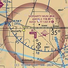
|
| Airport distance calculator |
|---|
|
|
| Sunrise and sunset |
|---|
|
Times for 30-May-2026
| | Local
(UTC-6) | | Zulu
(UTC) |
|---|
| Morning civil twilight | | 05:24 | | 11:24 |
| Sunrise | | 05:53 | | 11:53 |
| Sunset | | 20:10 | | 02:10 |
| Evening civil twilight | | 20:39 | | 02:39 |
|
| Current date and time |
|---|
| Zulu (UTC) | 30-May-2026 20:45:44 |
|---|
| Local (UTC-6) | 30-May-2026 14:45:44 |
|---|
|
| METAR |
|---|
| K0E0 | 302035Z AUTO 26013G19KT 10SM CLR 24/M07 A3006 RMK AO2 T02431071
|
KCQC
16nm E | ASOS 505-472-4551
301953Z AUTO 28018G27KT 10SM CLR 21/M08 A3011 RMK AO2 PK WND 25033/1913 SLP111 T02061078 $
|
|
| TAF |
|---|
KABQ
31nm W | 301951Z 3020/3118 28011KT P6SM SKC TEMPO 3021/3101 28011G21KT FM310100 31010KT P6SM SKC FM310600 VRB06KT P6SM SKC
|
|
| NOTAMs |
|---|
NOTAMs are issued by the DoD/FAA and will open in a separate window not controlled by AirNav.
|
|


