FAA INFORMATION EFFECTIVE 14 MAY 2026
Location
| FAA Identifier: | M45 |
| Lat/Long: | 38-44-05.1000N 119-46-01.4000W
38-44.085000N 119-46.023333W
38.7347500,-119.7670556
(estimated) |
| Elevation: | 5871.7 ft. / 1789.7 m (surveyed) |
| Variation: | 16E (1985) |
| From city: | 3 miles N of MARKLEEVILLE, CA |
| Time zone: | UTC -7 (UTC -8 during Standard Time) |
| Zip code: | 96120 |
Airport Operations
| Airport use: | Open to the public |
| Activation date: | 01/1968 |
| Control tower: | no |
| ARTCC: | OAKLAND CENTER |
| FSS: | RENO FLIGHT SERVICE STATION |
| NOTAMs facility: | RNO (NOTAM-D service available) |
| Attendance: | UNATNDD |
| Pattern altitude: | 6671.7 ft. MSL |
| Wind indicator: | yes |
| Segmented circle: | yes |
Airport Communications
| CTAF: | 122.9 |
| WX ASOS at TVL (14 nm NW): | 124.725 (530-573-5836) |
| WX AWOS-3PT at MEV (16 nm N): | 119.325 (775-782-6264) |
Nearby radio navigation aids
| VOR radial/distance | | VOR name | | Freq | | Var |
|---|
| SWRr123/35.6 | | PALISADES VOR/DME | | 113.20 | | 16E |
Airport Services
| Parking: | tiedowns |
| Airframe service: | NONE |
| Powerplant service: | NONE |
| Bottled oxygen: | NONE |
| Bulk oxygen: | NONE |
Runway Information
Runway 17/35
| Dimensions: | 4443 x 50 ft. / 1354 x 15 m |
| Surface: | asphalt, in poor condition
LOOSE GRVL ON RWY. |
| RUNWAY 17 | | RUNWAY 35 |
| Latitude: | 38-44.450493N | | 38-43.720373N |
| Longitude: | 119-45.992190W | | 119-46.053137W |
| Elevation: | 5827.3 ft. | | 5871.7 ft. |
| Traffic pattern: | left | | right |
| Runway heading: | 168 magnetic, 184 true | | 348 magnetic, 004 true |
| Markings: | basic, in fair condition | | basic, in fair condition |
| Runway end identifier lights: | no | | no |
| Touchdown point: | yes, no lights | | yes, no lights |
| Obstructions: | 150 ft. hill, 3200 ft. from runway, 425 ft. left of centerline, 20:1 slope to clear | | none |
Airport Ownership and Management from official FAA records
| Ownership: | Publicly-owned |
| Owner: | ALPINE COUNTY
50 DIAMOND VALLEY RD
MARKLEEVILLE, CA 96120
Phone 530-694-2140 |
| Manager: | SAM BOOTH
50 DIAMOND VALLEY RD
MARKLEEVILLE, CA 96120
Phone 530-694-2140
X 425 |
Additional Remarks
| - | LARGE STONES ALONG EDGE OF RWY OFF GRADED SFC. |
| - | NO SNOW REMOVAL, ARPT CLOSED WHEN SNOW ON RUNWAY. |
| - | TREES PENETRATING TRANSITIONAL SFCS E & W OF RY. |
| - | SOIL CONDITIONS OFF RY IS POOR IN WET CONDITIONS. CALL PUBLIC WORKS FOR ADDITIONAL INFORMATION 530-694-2140 EXT."0". |
| - | RY 17/35 LIMITED BY AIRPORT OPERATOR TO 4,800 LBS SINGLE WHEEL, 9,600 LBS DUAL WHEEL. |
| - | FOR CD CTC OAKLAND ARTCC AT 510-745-3380. |
Instrument Procedures
There are no published instrument procedures at M45.
Some nearby airports with instrument procedures:
KTVL - Lake Tahoe Airport (14 nm NW)
KMEV - Minden-Tahoe Airport (16 nm N)
KCXP - Carson City Airport (28 nm N)
O43 - Yerington Municipal Airport (33 nm NE)
KTRK - Truckee-Tahoe Airport (39 nm NW)
|
|

Road maps at:
MapQuest
Bing
Google
| Aerial photo |
|---|
WARNING: Photo may not be current or correct
 Photo taken 10-Aug-2013
looking south.
Photo taken 10-Aug-2013
looking south.
Do you have a better or more recent aerial photo of Alpine County Airport that you would like to share? If so, please send us your photo.
|
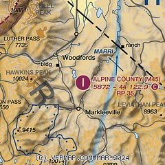
| Sectional chart |
|---|
|
| Airport distance calculator |
|---|
|
|
| Sunrise and sunset |
|---|
|
Times for 03-Jun-2026
| | Local
(UTC-7) | | Zulu
(UTC) |
|---|
| Morning civil twilight | | 05:05 | | 12:05 |
| Sunrise | | 05:36 | | 12:36 |
| Sunset | | 20:18 | | 03:18 |
| Evening civil twilight | | 20:50 | | 03:50 |
|
| Current date and time |
|---|
| Zulu (UTC) | 03-Jun-2026 19:06:54 |
|---|
| Local (UTC-7) | 03-Jun-2026 12:06:54 |
|---|
|
| METAR |
|---|
KTVL
15nm NW | 031853Z AUTO 04006KT 10SM CLR 22/04 A3024 RMK AO2 SLP189 T02170039
|
KMEV
16nm N | 031855Z AUTO 22004G13KT 10SM CLR 28/M07 A3013 RMK AO2
|
KBAN
26nm SE | 031852Z AUTO 10SM CLR 24/M04 A3023 RMK AO2 SLP136 T02441039 PWINO $
|
KCXP
28nm N | 031850Z AUTO 23008G14KT 10SM CLR 29/M10 A3014 RMK AO2
|
|
| TAF |
|---|
KTVL
15nm NW | 031720Z 0318/0418 19012G20KT P6SM FEW150 FM040300 19004KT P6SM SKC
|
KMEV
16nm N | 031720Z 0318/0418 25007KT P6SM SCT180 FM032000 27015G30KT P6SM SKC FM040300 28013KT P6SM SKC FM040600 10005KT P6SM SKC
|
|
| NOTAMs |
|---|
NOTAMs are issued by the DoD/FAA and will open in a separate window not controlled by AirNav.
|
|

