FAA INFORMATION EFFECTIVE 14 MAY 2026
Location
| FAA Identifier: | TRK |
| Lat/Long: | 39-19-12.2000N 120-08-22.5000W
39-19.203333N 120-08.375000W
39.3200556,-120.1395833
(estimated) |
| Elevation: | 5904.3 ft. / 1799.6 m (surveyed) |
| Variation: | 14E (2015) |
| From city: | 2 miles E of TRUCKEE, CA |
| Time zone: | UTC -7 (UTC -8 during Standard Time) |
| Zip code: | 96161 |
Airport Operations
| Airport use: | Open to the public |
| Activation date: | 10/1962 |
| Control tower: | yes |
| ARTCC: | OAKLAND CENTER |
| FSS: | RENO FLIGHT SERVICE STATION |
| NOTAMs facility: | TRK (NOTAM-D service available) |
| Attendance: | NOV-FEB 0700-2000, MAR-OCT 0700-2100
ATNDNC HRS DRG PST.
ATNDNC HRS DRG DST. |
| Pattern altitude: | 7004.3 ft. MSL |
| Wind indicator: | lighted |
| Segmented circle: | yes |
| Lights: | WHEN ATCT CLSD ACTVT REIL RWY 11; MIRL RWY 2/20 & 11/29; VASI RWY 20 - CTAF. |
| Beacon: | white-green (lighted land airport)
Operates sunset to sunrise. |
| Landing fee: | yes |
Airport Communications
| CTAF: | 120.575 |
| UNICOM: | 122.95 |
| TRUCKEE GROUND: | 118.3 [MAR 15-APR 30 0700-1930; MAY 1-AUG 31 0700-2000; SEP 1-30 0700-1900; OCT 1-MAR 14 0700-1800.] |
| TRUCKEE TOWER: | 120.575 [MAR 15-APR 30 0700-1930; MAY 1-AUG 31 0700-2000; SEP 1-30 0700-1900; OCT 1-MAR 14 0700-1800.] |
| D-ATIS: | 118.0 |
- APCH/DEP SVC PRVDD BY OAKLAND ARTCC ON 127.95 (SQUAW VALLEY RCAG) 316.1 (SACRAMENTO RCAG).
Nearby radio navigation aids
| VOR radial/distance | | VOR name | | Freq | | Var |
|---|
| SWRr020/10.3 | | PALISADES VOR/DME | | 113.20 | | 16E |
| FMGr225/25.7 | | MUSTANG VORTAC | | 117.90 | | 16E |
Airport Services
| Fuel available: | 100LL JET-A JET-A+
100LL:MOBILE FUEL AVBL 0700-1900; SELF-SERVE AVBL 0700-2000.
A:JETA/SAF |
| Oil available: | WHEN ATCT CLSD. |
| Parking: | hangars and tiedowns |
| Airframe service: | MAJOR |
| Powerplant service: | MINOR |
| Bottled oxygen: | LOW |
| Bulk oxygen: | NONE |
Runway Information
Runway 11/29
| Dimensions: | 7001 x 100 ft. / 2134 x 30 m |
| Surface: | asphalt/grooved, in good condition |
| Weight bearing capacity: | | Single wheel: | 50.0 | | Double wheel: | 80.0 |
|
| Runway edge lights: | medium intensity |
| RUNWAY 11 | | RUNWAY 29 |
| Latitude: | 39-19.490865N | | 39-18.914562N |
| Longitude: | 120-09.164548W | | 120-07.879025W |
| Elevation: | 5901.3 ft. | | 5892.6 ft. |
| Traffic pattern: | left | | left |
| Runway heading: | 106 magnetic, 120 true | | 286 magnetic, 300 true |
| Markings: | nonprecision, in good condition | | nonprecision, in good condition |
| Runway end identifier lights: | yes | | no |
| Touchdown point: | yes, no lights | | yes, no lights |
Runway 2/20
| Dimensions: | 4654 x 75 ft. / 1419 x 23 m |
| Surface: | asphalt/grooved, in good condition |
| Weight bearing capacity: | | Single wheel: | 35.0 | | Double wheel: | 50.0 |
|
| Runway edge lights: | medium intensity |
| RUNWAY 2 | | RUNWAY 20 |
| Latitude: | 39-18.871247N | | 39-19.535112N |
| Longitude: | 120-08.399323W | | 120-07.906053W |
| Elevation: | 5890.2 ft. | | 5890.3 ft. |
| Traffic pattern: | left | | right
GLDRS USE LEFT TFC RWY 20. |
| Runway heading: | 016 magnetic, 030 true | | 196 magnetic, 210 true |
| Displaced threshold: | no | | 115 ft. |
| Markings: | nonprecision, in good condition | | nonprecision, in good condition |
| Visual slope indicator: | | | 2-box VASI on left (3.50 degrees glide path)
UNUSBL BYD 2 DEGS LEFT OF CNTRLN. |
| Runway end identifier lights: | no | | no |
| Touchdown point: | yes, no lights | | yes, no lights |
Airport Ownership and Management from official FAA records
| Ownership: | Publicly-owned |
| Owner: | TRUCKEE-TAHOE AIRPORT DIST
10356 TRUCKEE AIRPORT RD
TRUCKEE, CA 96161
Phone 530-587-4540 |
| Manager: | ROBB ETNYRE
10356 TRUCKEE AIRPORT RD
TRUCKEE, CA 96161
Phone 530-587-4119 |
Additional Remarks
| - | RWY 20 & RWY 11 DIST-TO-GO MKRS INSTLD ON LEFT SIDE. |
| - | ACFT & HEL NOISE ABATEMENT RULES IN EFCT. PLS AVOID FLT OVER RESIDENTIAL AREAS, N, W, & S; CTC ARPT NOISE ABATEMENT OFC 530-587-4119 EXT 106 OR CHECK ARPT WEBSITE FOR COPY OF PROCS & RULES PRIOR TO ARR OR DEP. |
| - | NO DE-ICE SER AVAIL INDEF |
| - | SIMUL OPS ON RWYS 11/29 AND 2/20 MAY-SEP. |
| - | CLSD TO ULTRALIGHT ACT EXC BY PRIOR PMSN. |
| - | ACFT CPBL OF OPERG ABV 80,000 LBS MUST SMT CERTIF TO AMGR VFYG ACFT OPERG WT IS LESS THAN 80,000 LBS. |
| - | VOLUNTARY CURFEW: NO ENG STARTS ARR OR DEP EXC PPR OR LIFEGUARD/FIRE FIGHTING FLTS 2200-0700. |
| - | PREF CALM WIND RWY USE RWY 02. |
| - | NO ASR COVERAGE BLO 10,000 FT OVER KTRK |
| - | SPECIAL HAZARD: MOUNTAINOUS TRRN SRNDS ARPT AND RWYS; EXPC WINDSHEAR AND DOWNDRAFTS. |
| - | SUMMER DENSITY ALTS IN AFTNS FRQLY EXCEED 9000 FT. |
| - | COLD TEMPERATURE AIRPORT. ALTITUDE CORRECTION REQUIRED AT OR BELOW -17C. |
| - | WHEN ATCT CLSD, FOR CD CTC OAKLAND ARTCC AT 510-745-3380. |
| - | WILDLIFE ON AND INVOF ARPT. |
| - | GLDR OPNS NE OF ARPT MAY-SEP. |
Instrument Procedures
NOTE: All procedures below are presented as PDF files. If you need a reader for these files, you should download the free Adobe Reader.NOT FOR NAVIGATION. Please procure official charts for flight.
FAA instrument procedures published for use from 14 May 2026 at 0901Z to 11 June 2026 at 0900Z.
IAPs - Instrument Approach Procedures |
|---|
| RNAV (GPS) RWY 11 | |
download (360KB) |
| RNAV (GPS) RWY 20 | |
download (371KB) |
| RNAV (GPS)-A | |
download (309KB) |
| NOTE: Special Alternate Minimums apply | |
download (118KB) |
Departure Procedures |
|---|
| MOWGL TWO (RNAV) | |
download (227KB) |
|
|---|
| TRUCK FIVE (OBSTACLE) | |
2 pages:
[1] [2] (840KB) |
| NOTE: Special Take-Off Minimums/Departure Procedures apply | |
download (351KB) |
Other nearby airports with instrument procedures:
KRNO - Reno/Tahoe International Airport (20 nm NE)
KCXP - Carson City Airport (20 nm E)
KRTS - Reno/Stead Airport (24 nm NE)
KMEV - Minden-Tahoe Airport (26 nm SE)
KTVL - Lake Tahoe Airport (26 nm S)
|
|

Road maps at:
MapQuest
Bing
Google
| Aerial photo |
|---|
WARNING: Photo may not be current or correct
 Photo courtesy of Mitch Bowers Imagewerx.us Aerial Photography
Photo taken 10-May-2012
from 12,000' looking east.
Photo courtesy of Mitch Bowers Imagewerx.us Aerial Photography
Photo taken 10-May-2012
from 12,000' looking east.
Do you have a better or more recent aerial photo of Truckee-Tahoe Airport that you would like to share? If so, please send us your photo.
|
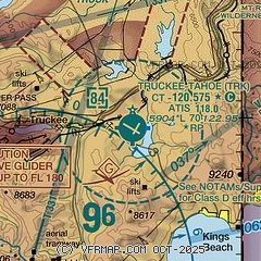
| Sectional chart |
|---|
|
| Airport distance calculator |
|---|
|
|
| Sunrise and sunset |
|---|
|
Times for 16-May-2026
| | Local
(UTC-7) | | Zulu
(UTC) |
|---|
| Morning civil twilight | | 05:17 | | 12:17 |
| Sunrise | | 05:47 | | 12:47 |
| Sunset | | 20:07 | | 03:07 |
| Evening civil twilight | | 20:37 | | 03:37 |
|
| Current date and time |
|---|
| Zulu (UTC) | 16-May-2026 09:47:31 |
|---|
| Local (UTC-7) | 16-May-2026 02:47:31 |
|---|
|
| METAR |
|---|
| KTRK | 160935Z AUTO 00000KT 10SM CLR 02/M02 A3007 RMK AO2
|
KRNO
20nm NE | 160855Z 35008KT 10SM SCT240 13/M07 A3001 RMK AO2 SLP117 T01331067 50003
|
|
| TAF |
|---|
| KTRK | 160521Z 1606/1706 VRB03KT P6SM SCT200 FM161900 30008KT P6SM FEW080 FEW200 FM170300 VRB04KT P6SM FEW200
|
KRNO
20nm NE | 160521Z 1606/1706 33010KT P6SM SCT200 FM161600 01008KT P6SM SCT200 FM162200 33012G22KT P6SM FEW100 FEW200
|
|
| NOTAMs |
|---|
NOTAMs are issued by the DoD/FAA and will open in a separate window not controlled by AirNav.
|
|


