FAA INFORMATION EFFECTIVE 16 APRIL 2026
Location
| FAA Identifier: | MRF |
| Lat/Long: | 30-22-16.0000N 104-01-03.1000W
30-22.266667N 104-01.051667W
30.3711111,-104.0175278
(estimated) |
| Elevation: | 4848.8 ft. / 1477.9 m (surveyed) |
| Variation: | 08E (2010) |
| From city: | 3 miles N of MARFA, TX |
| Time zone: | UTC -5 (UTC -6 during Standard Time) |
| Zip code: | 79843 |
Airport Operations
| Airport use: | Open to the public |
| Activation date: | 01/1947 |
| Control tower: | no |
| ARTCC: | ALBUQUERQUE CENTER |
| FSS: | SAN ANGELO FLIGHT SERVICE STATION |
| NOTAMs facility: | MRF (NOTAM-D service available) |
| Attendance: | 0800-1600 |
| Wind indicator: | lighted |
| Segmented circle: | yes |
| Lights: | MIRL RWY 13/31 PRESET LOW INTST; TO INCR INTST ACTVT - CTAF. |
| Beacon: | white-green (lighted land airport)
Operates sunset to sunrise. |
| Landing fee: | yes, LDG FEE WAIVED WITH MIN FUEL PURCHASE. |
Airport Communications
| CTAF/UNICOM: | 122.8 |
| WX AWOS-3PT: | 134.025 (432-729-3364) |
| WX AWOS-3 at E38 (17 nm E): | 119.025 (432-837-9613) |
- APCH/DEP SVC PRVDD BY ALBUQUERQUE ARTCC (ABQ) ON FREQS 135.875/292.15 (FORT STOCKTON RCAG).
Nearby radio navigation aids
| VOR radial/distance | | VOR name | | Freq | | Var |
|---|
| MRFr312/5.4 | | MARFA VOR/DME | | 115.90 | | 11E |
| NDB name | | Hdg/Dist | | Freq | | Var | | ID |
|---|
| KENT | | 159/39.8 | | 225 | | 07E | | XAA | -..- .- .- |
Airport Services
| Fuel available: | 100LL JET-A
100LL:100LL, JET-A, SELF SERVE AVLBL 24 HRS. |
| Parking: | tiedowns |
| Airframe service: | NONE |
| Powerplant service: | NONE |
| Bottled oxygen: | NONE |
| Bulk oxygen: | NONE |
Runway Information
Runway 13/31
| Dimensions: | 6203 x 75 ft. / 1891 x 23 m |
| Surface: | asphalt, in good condition |
| Weight bearing capacity: | |
| Runway edge lights: | medium intensity |
| RUNWAY 13 | | RUNWAY 31 |
| Latitude: | 30-22.684528N | | 30-21.957082N |
| Longitude: | 104-01.529777W | | 104-00.700088W |
| Elevation: | 4840.5 ft. | | 4830.0 ft. |
| Traffic pattern: | left | | left |
| Runway heading: | 127 magnetic, 135 true | | 307 magnetic, 315 true |
| Markings: | nonprecision, in good condition | | nonprecision, in good condition |
| Visual slope indicator: | 2-light PAPI on left (3.00 degrees glide path) | | 2-light PAPI on left (3.00 degrees glide path) |
| Touchdown point: | yes, no lights | | yes, no lights |
| Obstructions: | none | | 19 ft. tree, 870 ft. from runway, 250 ft. left of centerline, 35:1 slope to clear |
Runway 4/22
| Dimensions: | 5309 x 75 ft. / 1618 x 23 m |
| Surface: | asphalt, in good condition |
| Weight bearing capacity: | |
| RUNWAY 4 | | RUNWAY 22 |
| Latitude: | 30-21.942347N | | 30-22.558273N |
| Longitude: | 104-01.227485W | | 104-00.509632W |
| Elevation: | 4827.2 ft. | | 4848.7 ft. |
| Traffic pattern: | left | | left |
| Runway heading: | 037 magnetic, 045 true | | 217 magnetic, 225 true |
| Markings: | basic, in good condition | | basic, in good condition |
| Touchdown point: | yes, no lights | | yes, no lights |
Runway 9/27
| Dimensions: | 2825 x 60 ft. / 861 x 18 m |
| Surface: | dirt, in poor condition |
| RUNWAY 9 | | RUNWAY 27 |
| Latitude: | 30-22.179665N | | 30-22.174912N |
| Longitude: | 104-01.521655W | | 104-00.984338W |
| Elevation: | 4828.7 ft. | | 4834.5 ft. |
| Traffic pattern: | left | | left |
| Runway heading: | 083 magnetic, 091 true | | 263 magnetic, 271 true |
| Touchdown point: | yes, no lights | | yes, no lights |
| Obstructions: | 4 ft. fence, 132 ft. from runway, 33:1 slope to clear | | none |
Airport Ownership and Management from official FAA records
| Ownership: | Publicly-owned |
| Owner: | PRESIDIO COUNTY
P.O. BOX 606
MARFA, TX 79843
Phone 432-729-4452 |
| Manager: | RUDY ESTOR
45101 SH 17
MARFA, TX 79843
Phone 432-295-3906 |
Additional Remarks
| A58-04 | 12 FT TREE, 24 FT DSTC, 230 FT R. |
| - | 105 FT AGL LGTD WATER TWR 1168 FT SW OF AER 31. |
| - | GLIDER OPNS ON & INVOF ARPT. |
| - | WILDLIFE ON & INVOF ARPT. |
| - | PARL TWY ADJ RWY 04/22 CLSD EXC BTN TWY A AND RWY 13/31. |
| - | FOR CD IF UNA TO CTC ON FSS FREQ, CTC ALBUQUERQUE ARTCC AT 505-856-4561. |
| - | TWY A NORTHWEST OF RWY 04/22 CLSD TO ACFT MORE THAN 18000 LB. |
| - | RWY 9 THLD MKD W/3 WHITE TIRES EACH SIDE OF RWY CNTRLN. |
Instrument Procedures
NOTE: All procedures below are presented as PDF files. If you need a reader for these files, you should download the free Adobe Reader.NOT FOR NAVIGATION. Please procure official charts for flight.
FAA instrument procedures published for use from 16 April 2026 at 0901Z to 14 May 2026 at 0900Z.
IAPs - Instrument Approach Procedures |
|---|
| RNAV (GPS) RWY 31 **CHANGED** | |
download (187KB) |
| VOR RWY 31 **CHANGED** | |
download (204KB) |
| NOTE: Special Alternate Minimums apply | |
download (116KB) |
| NOTE: Special Take-Off Minimums/Departure Procedures apply | |
download (302KB) |
Other nearby airports with instrument procedures:
E38 - Alpine-Casparis Municipal Airport (17 nm E)
KPRS - Presidio Lely International Airport (48 nm S)
KVHN - Culberson County Airport (57 nm NW)
KFST - Fort Stockton-Pecos County Airport (66 nm NE)
KPEQ - Pecos Municipal Airport (66 nm NE)
|
|

Road maps at:
MapQuest
Bing
Google
| Aerial photo |
|---|
WARNING: Photo may not be current or correct

Do you have a better or more recent aerial photo of Marfa Municipal Airport that you would like to share? If so, please send us your photo.
|
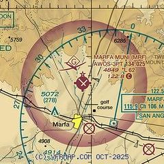
| Sectional chart |
|---|
|
| Airport distance calculator |
|---|
|
|
| Sunrise and sunset |
|---|
|
Times for 11-May-2026
| | Local
(UTC-5) | | Zulu
(UTC) |
|---|
| Morning civil twilight | | 06:39 | | 11:39 |
| Sunrise | | 07:06 | | 12:06 |
| Sunset | | 20:39 | | 01:39 |
| Evening civil twilight | | 21:05 | | 02:05 |
|
| Current date and time |
|---|
| Zulu (UTC) | 11-May-2026 11:47:15 |
|---|
| Local (UTC-5) | 11-May-2026 06:47:15 |
|---|
|
| METAR |
|---|
| KMRF | 111101Z AUTO 01014KT 10SM FEW015 12/09 A3031 RMK AO2 SLP205 T01220094 $
|
KE38
17nm E | 111135Z AUTO 05010KT 10SM OVC014 13/09 A3035 RMK AO2 T01310093
|
|
| NOTAMs |
|---|
NOTAMs are issued by the DoD/FAA and will open in a separate window not controlled by AirNav.
|
|


