FAA INFORMATION EFFECTIVE 09 JULY 2026
Location
| FAA Identifier: | MSO |
| Lat/Long: | 46-54-58.7000N 114-05-26.0000W
46-54.978333N 114-05.433333W
46.9163056,-114.0905556
(estimated) |
| Elevation: | 3205.6 ft. / 977.1 m (surveyed) |
| Variation: | 13E (2020) |
| From city: | 4 miles NW of MISSOULA, MT |
| Time zone: | UTC -6 (UTC -7 during Standard Time) |
| Zip code: | 59808 |
Airport Operations
| Airport use: | Open to the public |
| Activation date: | 07/1941 |
| Control tower: | yes |
| ARTCC: | SALT LAKE CITY CENTER |
| FSS: | GREAT FALLS FLIGHT SERVICE STATION |
| NOTAMs facility: | MSO (NOTAM-D service available) |
| Attendance: | CONTINUOUS |
| Wind indicator: | lighted |
| Segmented circle: | yes |
| Lights: | WHEN ATCT CLSD ACTVT MALSR RWY 12; PAPI RWY 30; MIRL 08/26; HIRL RWY 12/30 - CTAF. |
| Beacon: | white-green (lighted land airport)
Operates sunset to sunrise. |
| Landing fee: | yes |
| Fire and rescue: | ARFF index C |
Airport Communications
| CTAF: | 118.4 |
| UNICOM: | 122.95 |
| ATIS: | 126.65 |
| WX ASOS: | PHONE 406-213-9541 |
| MISSOULA GROUND: | 121.9 [0600-2200] |
| MISSOULA TOWER: | 118.4 377.175 [0600-2200] |
| SPOKANE APPROACH: | 124.9 |
| SPOKANE DEPARTURE: | 124.9 |
| IC: | 124.9 |
- APCH/DEP CTL SVC PRVDD BY SALT LAKE ARTCC (ZLC) ON FREQS 127.075/244.875 (MILLER PEAK RCAG) WHEN SPOKANE APCH CTL (GEG) IS UNAVBL 2320-0700.
- COMMUNICATIONS PRVDD BY GREAT FALLS RADIO ON FREQ 122.2 (MILLER PEAK RCO).
Nearby radio navigation aids
| VOR radial/distance | | VOR name | | Freq | | Var |
|---|
| MSO at field | | MISSOULA VOR/DME | | 112.80 | | 13E |
Airport Services
| Fuel available: | 100LL JET-A1+ |
| Parking: | hangars and tiedowns |
| Airframe service: | MAJOR |
| Powerplant service: | MAJOR |
| Bottled oxygen: | HIGH/LOW |
| Bulk oxygen: | HIGH/LOW |
Runway Information
Runway 12/30
| Dimensions: | 9501 x 150 ft. / 2896 x 46 m |
| Surface: | asphalt/grooved, in good condition |
| Weight bearing capacity: | | Single wheel: | 145.0, 180 DEG TURNS FOR ACFT OVR 12500 LBS GWT PROHIBITED ON ALL MOVEMENT AREAS. AVOID LOCKED TURNS AT ALL TIMES. | | Double wheel: | 170.0 | | Double tandem: | 255.0 |
|
| Runway edge lights: | high intensity |
| RUNWAY 12 | | RUNWAY 30 |
| Latitude: | 46-55.490665N | | 46-54.476547N |
| Longitude: | 114-06.393563W | | 114-04.658408W |
| Elevation: | 3192.4 ft. | | 3205.5 ft. |
| Traffic pattern: | left | | left |
| Runway heading: | 117 magnetic, 130 true | | 297 magnetic, 310 true |
| Declared distances: | TORA:9501 TODA:9501 ASDA:9501 LDA:9501 | | TORA:9501 TODA:9501 ASDA:9501 LDA:9501 |
| Markings: | precision, in good condition | | nonprecision, in good condition |
| Visual slope indicator: | 4-light PAPI on left (3.00 degrees glide path) | | 4-light PAPI on left (3.00 degrees glide path) |
| RVR equipment: | touchdown | | rollout |
| Approach lights: | MALSR: 1,400 foot medium intensity approach lighting system with runway alignment indicator lights | | |
| Runway end identifier lights: | no | | yes |
| Touchdown point: | yes, no lights | | yes, no lights |
| Instrument approach: | ILS | | |
Runway 8/26
| Dimensions: | 4612 x 75 ft. / 1406 x 23 m |
| Surface: | asphalt/grooved, in fair condition |
| Weight bearing capacity: | | Single wheel: | 30.0 | | Double wheel: | 50.0 |
|
| Runway edge lights: | medium intensity |
| RUNWAY 8 | | RUNWAY 26 |
| Latitude: | 46-54.960732N | | 46-54.969482N |
| Longitude: | 114-05.796817W | | 114-04.689812W |
| Elevation: | 3199.2 ft. | | 3204.2 ft. |
| Traffic pattern: | left | | left |
| Runway heading: | 076 magnetic, 089 true | | 256 magnetic, 269 true |
| Declared distances: | TORA:4612 TODA:4612 ASDA:4612 LDA:4612 | | TORA:4612 TODA:4612 ASDA:4612 LDA:4612 |
| Markings: | basic, in good condition | | basic, in good condition |
| Touchdown point: | yes, no lights | | yes, no lights |
Airport Ownership and Management from official FAA records
| Ownership: | Publicly-owned |
| Owner: | MISSOULA CTY ARPT AUTH
5225 WEST BROADWAY
MISSOULA, MT 59808
Phone 406-728-4381 |
| Manager: | BRIAN ELLESTAD
5225 WEST BROADWAY
MISSOULA, MT 59808
Phone 406-728-4381 |
Additional Remarks
| A39-12/30 | PCR VALUE: 730/F/D/X/T |
| A39-08/26 | PCR VALUE: 175/F/D/X/T |
| - | CONTACT ARPT MANAGER TO REQUEST APPROVAL PRIOR TO ULTRALIGHT OPNS. |
| - | COLD TEMPERATURE AIRPORT. ALTITUDE CORRECTION REQUIRED AT OR BELOW -11C. |
| - | PRCHTG AT OR ARND THE ARPT. |
| - | RWY 8/26 CLSD PERM |
| - | TWY G BTN RWY 08 END TO RWY 12/30 RSTRD TO ACFT UNDER 12500 LBS. |
| - | LDG FEE FOR ALL COML ACFT AND ALL ACFT OVER 9,000 LBS. |
| - | MIGRATORY & SMALL BIRD ACTVTY ON & INVOF ARPT YEAR ROUND. |
| - | HANG GLIDER OPS, PARAGLIDER ACT 5.5 NM EAST OF AER RWY 30. |
Instrument Procedures
NOTE: All procedures below are presented as PDF files. If you need a reader for these files, you should download the free Adobe Reader.NOT FOR NAVIGATION. Please procure official charts for flight.
FAA instrument procedures published for use from 09 July 2026 at 0901Z to 06 August 2026 at 0900Z.
IAPs - Instrument Approach Procedures |
|---|
| ILS Y RWY 12 | |
download (1081KB) |
| ILS Z RWY 12 | |
download (1056KB) |
| RNAV (RNP) RWY 30 | |
download (883KB) |
| RNAV (RNP) Z RWY 12 | |
download (955KB) |
| RNAV (GPS) Y RWY 12 | |
download (1038KB) |
| RNAV (GPS)-D | |
download (565KB) |
| VOR-A | |
download (630KB) |
| VOR-B | |
download (643KB) |
| NOTE: Special Alternate Minimums apply | |
download (185KB) |
Departure Procedures |
|---|
| DIDLY FIVE | |
download (220KB) |
| MZULA FIVE | |
download (247KB) |
| VICTO ONE (RNAV) | |
download (183KB) |
|
|---|
| GRZLY FOUR (OBSTACLE) | |
download (256KB) |
| NOTE: Special Take-Off Minimums/Departure Procedures apply | |
download (534KB) |
Other nearby airports with instrument procedures:
32S - Stevensville Airport (24 nm S)
7S0 - Ronan Airport (39 nm N)
KHRF - Ravalli County Airport (40 nm S)
8S1 - Polson Airport (47 nm N)
S69 - Lincoln Airport (59 nm E)
|
|

Road maps at:
MapQuest
Bing
Google
| Aerial photo |
|---|
WARNING: Photo may not be current or correct
 Photo by Trever Rossini
Photo taken 19-Apr-2010
looking east.
Photo by Trever Rossini
Photo taken 19-Apr-2010
looking east.
Do you have a better or more recent aerial photo of Missoula Montana Airport that you would like to share? If so, please send us your photo.
|
| Sectional chart |
|---|
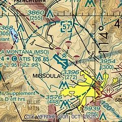
|
CAUTION: Diagram may not be current
 Download PDF
of official airport diagram from the FAA
| Airport distance calculator |
|---|
|
|
| Sunrise and sunset |
|---|
|
Times for 31-Jul-2026
| | Local
(UTC-6) | | Zulu
(UTC) |
|---|
| Morning civil twilight | | 05:40 | | 11:40 |
| Sunrise | | 06:16 | | 12:16 |
| Sunset | | 21:10 | | 03:10 |
| Evening civil twilight | | 21:45 | | 03:45 |
|
| Current date and time |
|---|
| Zulu (UTC) | 01-Aug-2026 02:23:13 |
|---|
| Local (UTC-6) | 31-Jul-2026 20:23:13 |
|---|
|
| METAR |
|---|
| KMSO | 010153Z 01007KT 10SM FU CLR 32/07 A3003 RMK AO2 SLP143 T03220067 $
|
|
| TAF |
|---|
| KMSO | 311720Z 3118/0118 VRB03KT P6SM SKC FM312100 35008KT P6SM SKC FM010300 VRB03KT 6SM FU SKC
|
|
| NOTAMs |
|---|
NOTAMs are issued by the DoD/FAA and will open in a separate window not controlled by AirNav.
|
|


