FAA INFORMATION EFFECTIVE 14 MAY 2026
Location
| FAA Identifier: | NGW |
| Lat/Long: | 27-42-08.7105N 097-26-19.7485W
27-42.145175N 097-26.329142W
27.7024196,-97.4388190
(estimated) |
| Elevation: | 31.7 ft. / 9.7 m (surveyed) |
| Variation: | 05E (2010) |
| From city: | 3 miles SW of CORPUS CHRISTI, TX |
| Time zone: | UTC -5 (UTC -6 during Standard Time) |
| Zip code: | 78415 |
Airport Operations
| Airport use: | Private use. Permission required prior to landing |
| Activation date: | 07/1943 |
| Control tower: | yes |
| ARTCC: | HOUSTON CENTER |
| FSS: | SAN ANGELO FLIGHT SERVICE STATION |
| NOTAMs facility: | SJT (NOTAM-D service available) |
| Attendance: | MON-THU 1400-0500Z, ALL FRI 1400-0100Z
DT 1300-0400Z MON-THU, 1300-0000Z FRI. |
| Segmented circle: | no |
| Lights: | AVBL ONLY DURG HRS OF OPN. |
Airport Communications
| NAVY CABANISS TOWER: | 119.65 299.6 [1400-0500Z++ MON-THU; 1400-0100Z++ FRI; (DT 1300-0400Z MON-THU; 1300-0000Z FRI).] |
| CORPUS APPROACH: | 125.4 |
| CORPUS DEPARTURE: | 125.4 |
| WX ASOS at CRP (5 nm NW): | PHONE 361-267-5360 |
| WX AWOS-3 at RBO (14 nm W): | 118.175 (361-767-1982) |
| WX AWOS-3 at TFP (17 nm NE): | 118.775 (361-758-8961) |
| WX AWOS-3 at RAS (20 nm E): | 118.425 (361-749-0537) |
Nearby radio navigation aids
| VOR radial/distance | | VOR name | | Freq | | Var |
|---|
| CRPr169/12.1 | | CORPUS CHRISTI VORTAC | | 115.50 | | 09E |
| ALIr088/(31.0) | | ALICE VOR | | 114.50 | | 06E |
Airport Services
| Bottled oxygen: | NONE |
| Bulk oxygen: | NONE |
Runway Information
Runway 13/31
| Dimensions: | 4994 x 150 ft. / 1522 x 46 m |
| Surface: | asphalt, in good condition |
| Weight bearing capacity: | |
| Runway edge lights: | high intensity |
| RUNWAY 13 | | RUNWAY 31 |
| Latitude: | 27-42.383630N | | 27-41.799752N |
| Longitude: | 097-26.565348W | | 097-25.911928W |
| Elevation: | 30.3 ft. | | 19.2 ft. |
| Traffic pattern: | left | | left |
| Runway heading: | 130 magnetic, 135 true | | 310 magnetic, 315 true |
| Markings: | basic, in good condition | | basic, in good condition |
| Visual slope indicator: | 4-light PAPI on right (3.00 degrees glide path) | | 4-light PAPI on left (3.00 degrees glide path) |
| Touchdown point: | yes, no lights | | yes, no lights |
Runway 18/36
| Dimensions: | 4496 x 150 ft. / 1370 x 46 m |
| Surface: | asphalt/concrete, in good condition |
| Weight bearing capacity: | |
| Runway edge lights: | high intensity |
| RUNWAY 18 | | RUNWAY 36 |
| Latitude: | 27-42.575540N | | 27-41.833630N |
| Longitude: | 097-26.428745W | | 097-26.430600W |
| Elevation: | 31.5 ft. | | 22.4 ft. |
| Traffic pattern: | left | | left |
| Runway heading: | 175 magnetic, 180 true | | 355 magnetic, 000 true |
| Markings: | basic, in good condition | | basic, in good condition |
| Visual slope indicator: | | | 4-light PAPI on left (3.00 degrees glide path) |
| Touchdown point: | yes, no lights | | yes, no lights |
Airport Ownership and Management from official FAA records
| Ownership: | U.S. Navy |
| Owner: | US NAVY
OCEANOGRAPHIC OFC - CODE 3142
WASHINGTON, DC 20373 |
Additional Remarks
| E60-18 | A-GEAR 1000 FT FM ROLLOUT END. |
| E60-13 | A-GEAR 1000 FT FM ROLLOUT END. |
| - | RSTD: NAVY TRNG ONLY. |
| - | MISC: TWY D AND E UNLGTD, AVBL FOR DAYTIME USE ONLY. |
| - | CAUTION: IF EQUIPPED ALL ACFT SHALL UTILIZE UHF ATC FREQS UNLESS ASSIGNED VHF. |
| - | NO PRKG APN AVBL. |
| - | FOR CD CTC CORPUS CHRISTI APCH AT 361-299-4230. |
| - | FLD HRS SUBJ CHG VIA NOTAM. |
Instrument Procedures
There are no published instrument procedures at KNGW.
Some nearby airports with instrument procedures:
KCRP - Corpus Christi International Airport (5 nm NW)
KNGP - Corpus Christi Naval Air Station (Truax Field) Airport (8 nm E)
KRBO - Nueces County Airport (14 nm W)
KTFP - Ingleside Regional Airport (17 nm NE)
KRAS - Mustang Beach Airport (20 nm E)
|
|

Road maps at:
MapQuest
Bing
Google
| Aerial photo |
|---|

|
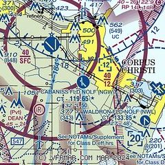
| Sectional chart |
|---|
|
| Airport distance calculator |
|---|
|
|
| Sunrise and sunset |
|---|
|
Times for 30-May-2026
| | Local
(UTC-5) | | Zulu
(UTC) |
|---|
| Morning civil twilight | | 06:09 | | 11:09 |
| Sunrise | | 06:36 | | 11:36 |
| Sunset | | 20:19 | | 01:19 |
| Evening civil twilight | | 20:45 | | 01:45 |
|
| Current date and time |
|---|
| Zulu (UTC) | 31-May-2026 00:46:31 |
|---|
| Local (UTC-5) | 30-May-2026 19:46:31 |
|---|
|
| METAR |
|---|
KCRP
5nm NW | 302351Z 12010KT 10SM FEW023 FEW030 SCT250 29/22 A2984 RMK AO2 SLP105 T02890222 10322 20289 58003
|
KNGP
9nm E | 302356Z AUTO 13010KT 10SM CLR 28/23 A2985 RMK AO2 SLP107 T02830233 10311 20283 57006 $
|
KRBO
14nm W | 310035Z AUTO 13007KT CLR 28/23 A2985 RMK AO2 T02750233 PWINO
|
KTFP
17nm NE | 302335Z AUTO 15011KT 10SM CLR 31/24 A2985 RMK AO1 T03100236
|
KRAS
20nm E | 310035Z AUTO 11008KT 10SM CLR 28/23 A2988 RMK AO2 T02780233
|
|
| TAF |
|---|
KCRP
5nm NW | 301720Z 3018/3118 19007KT P6SM FEW025 SCT150 FM310900 VRB05KT P6SM BKN018 FM311600 12007KT P6SM BKN130
|
KNGP
9nm E | 3100/3123 111010G15KT 9999 SCT020 OVC120 QNH2977INS FM310900 15008KT 8000 BR SCT015 OVC080 QNH2979INS TEMPO 3109/3114 4800 BR BKN010 OVC050 AUTOMATED FM311500 12013G18KT 9999 SCT030 BKN120 OVC250 QNH2976INS SENSOR METWATCH 3107 TIL 0111 TX29/3120Z TN26/3106Z COR 0000 FN00319
|
|
| NOTAMs |
|---|
NOTAMs are issued by the DoD/FAA and will open in a separate window not controlled by AirNav.
|
|

