FAA INFORMATION EFFECTIVE 16 APRIL 2026
Location
| FAA Identifier: | TOG |
| Lat/Long: | 59-03-12.8000N 160-23-48.4000W
59-03.213333N 160-23.806667W
59.0535556,-160.3967778
(estimated) |
| Elevation: | 18.6 ft. / 5.7 m (surveyed) |
| Variation: | 11E (2020) |
| Time zone: | UTC -8 (UTC -9 during Standard Time) |
| Zip code: | 99678 |
Airport Operations
| Airport use: | Open to the public |
| Activation date: | 08/1975 |
| Control tower: | no |
| ARTCC: | ANCHORAGE CENTER |
| FSS: | KENAI FLIGHT SERVICE STATION [907-283-7211] |
| NOTAMs facility: | TOG (NOTAM-D service available) |
| Attendance: | UNATNDD |
| Wind indicator: | lighted |
| Segmented circle: | yes |
| Lights: | ACTVT PAPI RWY 03 & 21; MIRL RWY 03/21 - CTAF. |
| Beacon: | white-green (lighted land airport)
ACTVT ROTG BCN - CTAF. |
Airport Communications
| CTAF: | 122.5 |
| WX AWOS-3P: | 119.3 (907-560-7601) |
- APCH/DEP SVC PRVDD BY ANCHORAGE ARTCC (ZAN) ON FREQ 132.75/282.35 (DILLINGHAM RCAG).
Nearby radio navigation aids
| NDB name | | Hdg/Dist | | Freq | | Var | | ID |
|---|
| TOGIAK | | at field | | 393 | | 11E | | TOG | - --- --. |
Airport Services
Runway Information
Runway 3/21
| Dimensions: | 4400 x 100 ft. / 1341 x 30 m |
| Surface: | gravel/dirt, in good condition |
| Runway edge lights: | medium intensity |
| RUNWAY 3 | | RUNWAY 21 |
| Latitude: | 59-02.907523N | | 59-03.449573N |
| Longitude: | 160-24.347632W | | 160-23.421090W |
| Elevation: | 18.6 ft. | | 18.3 ft. |
| Traffic pattern: | left | | left |
| Runway heading: | 031 magnetic, 042 true | | 211 magnetic, 222 true |
| Markings: | none, in good condition | | none, in good condition |
| Visual slope indicator: | 4-light PAPI on left (3.00 degrees glide path) | | 4-light PAPI on left (3.00 degrees glide path) |
| Touchdown point: | yes, no lights | | yes, no lights |
| Obstructions: | 15 ft. road, 100 ft. right of centerline
CTLG OBSTN EXCEEDS A 45 DEG SLOPE. | | none |
Runway 10/28
| Dimensions: | 982 x 59 ft. / 299 x 18 m |
| Surface: | gravel, in fair condition |
| Runway edge markings: | THR MKRS DMGD OR MISG. |
| RUNWAY 10 | | RUNWAY 28 |
| Latitude: | 59-03.400518N | | 59-03.341335N |
| Longitude: | 160-23.606877W | | 160-23.315745W |
| Elevation: | 16.1 ft. | | 16.7 ft. |
| Traffic pattern: | left | | left |
| Runway heading: | 101 magnetic, 112 true | | 281 magnetic, 292 true |
| Markings: | NSTD, in fair condition | | NSTD, in fair condition |
| Touchdown point: | yes, no lights | | yes, no lights |
| Obstructions: | none | | 41 ft. bldg, 270 ft. from runway, 163 ft. left of centerline, 11:1 slope to clear |
Airport Ownership and Management from official FAA records
| Ownership: | Publicly-owned |
| Owner: | ALASKA DOT&PF CENTRAL REGION
PO BOX 196900
ANCHORAGE, AK 99519-6900
Phone 907-269-0749 |
| Manager: | KEVIN HARDIN
BOX 214
DILLINGHAM, AK 99576
Phone 907-842-5511 |
Additional Remarks
| - | RWY COND UNMNT, RCMD VISUAL INSP BFR USE. |
| - | WX CAMERAS AVBL ON INTERNET AT HTTPS://WEATHERCAMS.FAA.GOV |
| - | WATERFOWL INVOF ARPT. |
Instrument Procedures
NOTE: All procedures below are presented as PDF files. If you need a reader for these files, you should download the free Adobe Reader.NOT FOR NAVIGATION. Please procure official charts for flight.
FAA instrument procedures published for use from 16 April 2026 at 0901Z to 14 May 2026 at 0900Z.
IAPs - Instrument Approach Procedures |
|---|
| RNAV (GPS) RWY 03 | |
download (236KB) |
| RNAV (GPS) RWY 21 | |
download (230KB) |
| NOTE: Special Alternate Minimums apply | |
download (61KB) |
| NOTE: Special Take-Off Minimums/Departure Procedures apply | |
download (245KB) |
Other nearby airports with instrument procedures:
PAPM - Platinum Airport (44 nm W)
PAMB - Manokotak Airport (47 nm E)
PAEH - Cape Newenham LRRS Airport (57 nm SW)
PADL - Dillingham Airport (58 nm E)
PFCL - Clarks Point Airport (59 nm E)
|
|

Road maps at:
MapQuest
Bing
Google
| Aerial photo |
|---|
WARNING: Photo may not be current or correct
 Photo by Brian Kellogg
Do you have a better or more recent aerial photo of Togiak Airport that you would like to share? If so, please send us your photo.
|
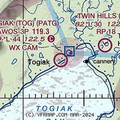
| Sectional chart |
|---|
|
| Airport distance calculator |
|---|
|
|
| Sunrise and sunset |
|---|
|
Times for 18-Apr-2026
| | Local
(UTC-8) | | Zulu
(UTC) |
|---|
| Morning civil twilight | | 06:34 | | 14:34 |
| Sunrise | | 07:19 | | 15:19 |
| Sunset | | 22:02 | | 06:02 |
| Evening civil twilight | | 22:48 | | 06:48 |
|
| Current date and time |
|---|
| Zulu (UTC) | 18-Apr-2026 14:12:05 |
|---|
| Local (UTC-8) | 18-Apr-2026 06:12:05 |
|---|
|
| METAR |
|---|
| PATG | 181356Z AUTO 19007KT 3/4SM BR OVC003 M03/M03 A3004 RMK AO2 SLP174 T10281033 FZRANO
|
|
| NOTAMs |
|---|
NOTAMs are issued by the DoD/FAA and will open in a separate window not controlled by AirNav.
|
|

