FAA INFORMATION EFFECTIVE 14 MAY 2026
Location
| FAA Identifier: | ELI |
| Lat/Long: | 64-36-53.9000N 162-16-13.9000W
64-36.898333N 162-16.231667W
64.6149722,-162.2705278
(estimated)
SURVEYED |
| Elevation: | 161.5 ft. / 49 m (estimated) |
| Variation: | 09E (2025) |
| From city: | 3 miles SW of ELIM, AK |
| Time zone: | UTC -8 (UTC -9 during Standard Time) |
| Zip code: | 99739 |
Airport Operations
| Airport use: | Open to the public |
| Activation date: | 10/1952 |
| Control tower: | no |
| ARTCC: | ANCHORAGE CENTER |
| FSS: | NOME FLIGHT SERVICE STATION [ 443-2291 (local call from the AIRPORT)] |
| Alternate FSS: | FAI FAIRBANKS FLIGHT SERVICE STATION [1-866-248-6516] |
| NOTAMs facility: | ELI (NOTAM-D service available) |
| Attendance: | UNATNDD |
| Wind indicator: | lighted |
| Segmented circle: | yes |
| Lights: | ACTVT MIRL RY 01/19 - CTAF. |
| Beacon: | white-green (lighted land airport)
Operates sunset to sunrise. |
Airport Communications
| CTAF: | 122.8 |
| WX AWOS-3P: | 121.425 (907-890-2014) |
| WX AWOS-3P at GLV (19 nm W): | 135.750 (907-779-2228) |
- APCH/DEP SVC PRVDD BY ANCHORAGE ARTCC ON FREQS 133.3/290.4 (NOME RCAG).
- COMMUNICATIONS PRVDD BY NOME FSS ON FREQ 122.15 (ELIM RCO).
Nearby radio navigation aids
| VOR radial/distance | | VOR name | | Freq | | Var |
|---|
| MOSr210/7.1 | | MOSES POINT VOR/DME | | 116.30 | | 16E |
Airport Services
| Airframe service: | NONE |
| Powerplant service: | NONE |
| Bottled oxygen: | NONE |
| Bulk oxygen: | NONE |
Runway Information
Runway 1/19
| Dimensions: | 3401 x 60 ft. / 1037 x 18 m |
| Surface: | gravel/dirt, in good condition |
| Runway edge lights: | medium intensity |
| Runway edge markings: | RWY 01/19 MARKED WITH LIGHTS AND PLASTIC MARKERS. |
| Operational restrictions: | RY 19 SLOPES UPHILL 0.5% TO SOUTH END. |
| RUNWAY 1 | | RUNWAY 19 |
| Latitude: | 64-36.654958N | | 64-37.142015N |
| Longitude: | 162-16.549057W | | 162-15.915618W |
| Elevation: | 161.5 ft. | | 123.0 ft. |
| Traffic pattern: | right | | left |
| Runway heading: | 020 magnetic, 029 true | | 200 magnetic, 209 true |
| Markings: | none, in fair condition | | none, in fair condition |
| Touchdown point: | yes, no lights | | yes, no lights |
| Obstructions: | 12 ft. tree, 20 ft. from runway, 216 ft. right of centerline, 1:1 slope to clear | | 744 ft. hill, 8700 ft. from runway, 11:1 slope to clear
RY 19, +744 FT HILL, DIST 8700 FT FM RY 19 END, 500 FT R. |
Airport Ownership and Management from official FAA records
| Ownership: | Publicly-owned |
| Owner: | ALASKA DOT&PF NORTHERN REGION
2301 PEGER RD
FAIRBANKS, AK 99701
Phone 907-451-2200 |
| Manager: | JOHN WILSON
PO BOX 192
UNALAKLEET, AK 99684
Phone (907) 625-1025 |
Additional Remarks
| - | RY CONDITION NOT MONITORED; RECOMMEND VISUAL INSPECTION PRIOR TO LANDING. |
| - | +744 FT HILL 8700 FT FM RY END 500 FT R. |
| - | WX CAMERA AVBL ON INTERNET AT HTTPS://WEATHERCAMS.FAA.GOV |
| - | COLD TEMPERATURE AIRPORT. ALTITUDE CORRECTION REQUIRED AT OR BELOW -34C. |
| - | SINKING AREA MIDFIELD WEST SIDE OF RWY 10'INSIDE LIGHTS 20' OUTSIDE. |
Instrument Procedures
NOTE: All procedures below are presented as PDF files. If you need a reader for these files, you should download the free Adobe Reader.NOT FOR NAVIGATION. Please procure official charts for flight.
FAA instrument procedures published for use from 14 May 2026 at 0901Z to 11 June 2026 at 0900Z.
IAPs - Instrument Approach Procedures |
|---|
| RNAV (GPS) RWY 01 | |
download (211KB) |
| RNAV (GPS)-A | |
download (188KB) |
| NOTE: Special Alternate Minimums apply | |
download (172KB) |
|
|---|
| ELIM TWO (OBSTACLE) (RNAV) | |
download (143KB) |
| NOTE: Special Take-Off Minimums/Departure Procedures apply | |
download (148KB) |
Other nearby airports with instrument procedures:
PAGL - Golovin Airport (19 nm W)
PAWM - White Mountain Airport (30 nm W)
PFSH - Shaktoolik Airport (31 nm SE)
PAKK - Koyuk Alfred Adams Airport (35 nm NE)
PAUN - Unalakleet Airport (58 nm SE)
|
|

Road maps at:
MapQuest
Bing
Google
| Aerial photo |
|---|

|
| Sectional chart |
|---|
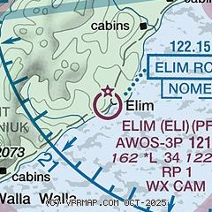
|
| Airport distance calculator |
|---|
|
|
| Sunrise and sunset |
|---|
|
Times for 04-Jun-2026
| | Local
(UTC-8) | | Zulu
(UTC) |
|---|
| Morning civil twilight | | + | | + |
| Sunrise | | 04:27 | | 12:27 |
| Sunset | | 01:08 | | 09:08 |
| Evening civil twilight | | + | | + |
|
| Current date and time |
|---|
| Zulu (UTC) | 05-Jun-2026 07:03:41 |
|---|
| Local (UTC-8) | 04-Jun-2026 23:03:41 |
|---|
|
| METAR |
|---|
| PFEL | 050656Z AUTO 00000KT 10SM CLR 09/02 A3010 RMK AO2 SLP194 T00940017 $
|
|
| NOTAMs |
|---|
NOTAMs are issued by the DoD/FAA and will open in a separate window not controlled by AirNav.
|
|

