FAA INFORMATION EFFECTIVE 22 JANUARY 2026
Location
| FAA Identifier: | PMD |
| Lat/Long: | 34-37-45.8000N 118-05-04.3900W
34-37.763333N 118-05.073167W
34.6293889,-118.0845528
(estimated) |
| Elevation: | 2542.5 ft. / 775.0 m (surveyed) |
| Variation: | 12E (2020) |
| From city: | 3 miles NE of PALMDALE, CA |
| Time zone: | UTC -8 (UTC -7 during Daylight Saving Time) |
| Zip code: | 93550 |
Airport Operations
| Airport use: | Open to the public, OFFICAL BUSINESS ONLY. MILITARY ARPT. CIVIL USE REQUIRES USAF APPROVAL AND DD FORM 2400/01/02. |
| Control tower: | yes |
| ARTCC: | LOS ANGELES CENTER |
| FSS: | RIVERSIDE FLIGHT SERVICE STATION |
| NOTAMs facility: | PMD (NOTAM-D service available) |
| Attendance: | 1330-0600Z++
CLSD FED HOL.
OTHER TIMES CLSD TO ALL TFC WITHOUT WRITTEN APVL. |
| Pattern altitude: | TPA OHD 1957 FT. RECTANGULAR 1457 FT. EXP RIGHT TFC RWY 04, 25. |
| Wind indicator: | yes |
| Segmented circle: | yes |
| Lights: | PAPI RWY 04, 07, 22, & 25 OPR CONSLY. |
| Beacon: | white-green (lighted land airport)
Operates sunset to sunrise. |
| Landing fee: | yes |
Airport Communications
| CTAF: | 123.7 |
| ATIS: | 118.275 |
| WX ASOS: | PHONE 661-272-3798 |
| PALMDALE GROUND: | 121.9 317.6 [OPR 1330-0600Z++.] |
| PALMDALE TOWER: | 123.7 317.6 236.6 [OPR 1330-0600Z++.] |
| JOSHUA APPROACH: | 124.55 |
| JOSHUA DEPARTURE: | 124.55 |
| EMERG: | 121.5 243.0 |
| WX ASOS at WJF (9 nm NW): | PHONE 661-949-2840 |
- WHEN ATCT CLSD ARPT CLSD TO ALL TFC WITHOUT WRITTEN APVL, DUE TO MILITARY OPS DURING TOWER CLOSURE.
Nearby radio navigation aids
| VOR radial/distance | | VOR name | | Freq | | Var |
|---|
| PMDr248/1.0 | | PALMDALE VORTAC | | 115.55 | | 15E |
| LHSr083/24.5 | | LAKE HUGHES VORTAC | | 114.35 | | 15E |
| EDWr207/27.4 | | EDWARDS VORTAC | | 116.40 | | 12E |
| VNYr025/31.6 | | VAN NUYS VOR/DME | | 113.10 | | 15E |
| VCVr260/34.4 | | VICTORVILLE VOR/DME | | 109.05 | | 14E |
| POMr321/36.2 | | POMONA VORTAC | | 110.40 | | 15E |
| GMNr089/39.7 | | GORMAN VORTAC | | 116.10 | | 16E |
Airport Services
Runway Information
Runway 7/25
| Dimensions: | 12002 x 200 ft. / 3658 x 61 m
1000 FT ASPH OVRN EACH END; OVRN POOR COND EMERG USE ONLY. |
| Surface: | concrete, in good condition |
| Weight bearing capacity: | |
| Runway edge lights: | high intensity |
| RUNWAY 7 | | RUNWAY 25 |
| Latitude: | 34-37.835100N | | 34-37.966517N |
| Longitude: | 118-06.783817W | | 118-04.395717W |
| Elevation: | 2540.2 ft. | | 2498.7 ft. |
| Traffic pattern: | left | | right |
| Runway heading: | 074 magnetic, 086 true | | 254 magnetic, 266 true |
| Markings: | nonprecision, in good condition | | precision, in good condition |
| Visual slope indicator: | 4-light PAPI on left (3.00 degrees glide path)
UNUSBL BYD 5.0 NM DUE TO TRRN. | | 4-light PAPI on left (3.00 degrees glide path) |
| Runway end identifier lights: | no | | no |
| Touchdown point: | yes, no lights | | yes, no lights |
| Instrument approach: | | | ILS |
Runway 4/22
| Dimensions: | 12001 x 150 ft. / 3658 x 46 m |
| Surface: | concrete, in good condition |
| Weight bearing capacity: | |
| Runway edge lights: | high intensity |
| RUNWAY 4 | | RUNWAY 22 |
| Latitude: | 34-37.014033N | | 34-38.237267N |
| Longitude: | 118-05.496700W | | 118-03.616100W |
| Elevation: | 2542.5 ft. | | 2491.1 ft. |
| Traffic pattern: | right | | left |
| Runway heading: | 040 magnetic, 052 true | | 220 magnetic, 232 true |
| Markings: | basic, in good condition | | basic, in good condition |
| Visual slope indicator: | 4-light PAPI on left (3.00 degrees glide path)
UNUSBL BYD 5.0 NM. | | 4-light PAPI on left (3.00 degrees glide path) |
| Runway end identifier lights: | no | | no |
| Touchdown point: | yes, no lights | | yes, no lights |
| Obstructions: | hill, 35:1 slope to clear
23000' FM THR. | | none |
Runway 72/252
| Dimensions: | 6000 x 75 ft. / 1829 x 23 m |
| Surface: | concrete, in excellent condition |
| Weight bearing capacity: | |
| Operational restrictions: | RY USED AS A MILITARY ASSAULT STRIP. |
| RUNWAY 72 | | RUNWAY 252 |
| Traffic pattern: | left | | left |
Airport Ownership and Management from official FAA records
| Ownership: | U.S. Air Force |
| Owner: | USAF
2503 E AVE P
PALMDALE, CA 93550-2196
Phone 661-275-9341
KEN NEITZEL, FLIGHT DIRECTOR, PHONE 661-275-9341. |
| Manager: | MATT FISHER
2503 E AVE P
PALMDALE, CA 93550-2196
Phone 661-275-9342
CIVILIAN AIRPORT CONTACT AT 39516 NORTH 25TH STREET E, PALMDALE, CA 93550, CURRENTLY CLOSED. |
Additional Remarks
| - | MISC: INDUS INSTLN - NO TRNSPN, LODGING OR NML SVC AVBL ON SITE. |
| - | UNLGT OBSTN SURROUND AFLD. |
| - | DRAINAGE DITCHES PARL RWY 22 FM TWY S TO TWY U. |
| - | BIRD HAZ POTENTIAL EXISTS. MIGRATORY SEASON PHASE II 1 OCT - 31 MAR. DURG BWC MODERATE, TKOF AND LNDG PERMITTED. DURG BWC SEVERE, TKOF AND LNDG PROHIBITED. |
| - | MILITARY USE: ASSAULT LDG ZONE LCTD 1ST 6,000 EAST END OF TWY B. RWY 252 MRK ONLY FOR C-130 ASSAULT OPR; ONE-WAY LDG ONLY. |
| - | MISC: WINDS ARE EST DUE TO FMQ-13 WIND SENSORS BEING ACCURATE TO WITHIN ONLY +/- 2 KT. ATC/WX WILL NOT INCL/RELAY WIND CORR INTO FCST/PHRASEOLOGY. THEREFORE, AIRCREWS WILL INCORPORATE A +/- 2 KT ACCURACY INTO THEIR DECISION MAKING PROCESS FOR FLYING OPR. |
| - | TRAN ALERT (1 OF 2): NO FLEET SVC AVBL. NO FLW ME SVC AVBL. EXP PROGRESSIVE TAXI TO PRK. AIRCREW RESPONSIBLE FOR ACFT PINNING/SAFING. |
| - | MISC: COMSEC STORAGE UNAVBL. |
| - | PRKG RAMP LCTD S OF RWY 22 & TWY V NOT VSB FM ATCT. |
| - | CAUTION: USE EXTREME CAUTION FOR UNMANNED AERIAL SYSTEMS (UAS) OPS IN VCNTY. |
| - | FUEL: A++ AVBL. NO TRANS ACFT FUEL SVC AVBL. LTD FUELING AVBL; GOVT ACFT ONLY 1600-2300Z++ MON-FRI. 24 HR PN WITH AFLD MGR RQR; NO SAME DAY REQ; GAS AND GO UNAVBL. EXPECT 2+ HR DELAY FOR FUEL. |
| - | RSTD - OFFL BUS ONLY. MIL ARPT. CIVIL USE RQR USAF APVL AND DD FORM 2400/01/02. PPR RQR FOR FULL STOP LDG ONLY. CALL C661-275-9342. |
| - | TRAN ALERT (2 OF 2): UNABLE TO SVC ACFT WITH ORDNANCE. LTD GRD SUPPORT EQUIPMENT AVBL. NO POTABLE WATER SVC. NO TRAN MAINT AVBL. GND SVC UNAVBL WHEN LIGHTNING WITHIN 5 NM. |
| - | MISC: FLT PLANS MUST BE FILED AND ACTIVATED WITH P42 AFLD MGMT. USE FLT SVC WHEN P42 AFLD MGMT CLSD. |
| - | CAUTION: VARIOUS ACFT TEST OPS MARKINGS PAINTED IN WHITE ON TAXIWAY UNIFORM. |
| - | CAUTION: RWY 25 NSTD MRK: SPOT LDG ZONE MRK LCTD AT 6000 FT REMAINING MRK. RWY 07-25 DECEPTIVE SFC MRK EXCEED STANDARD BY APPROX 50 FT. |
| - | RSTD: OVERNIGHT PRK UNAUTHD ON C-RAMP. |
| - | RSTD: TWY L BTN RWY 04/22 AND PAX TRML UNLGTD AND USABLE FOR DAYLT VFR ONLY. |
| - | ALL DEPT ACFT MUST FILE FPL WITH P42 AFLD MGMT OPS. |
| - | SERVICE-JASU: POWER CARS UNAVBL. |
| - | MISC: BASE OPS OPR 1330-0600Z++, CLSD FEDERAL HOL. |
| - | CAUTION: CONTRACTOR LEASED SITES ARE INTENDED FOR ACFT BASED THEREIN; ENTRY GATES AND APRONS MAY NOT MEET AF OBST STDS. |
| - | CAUTION: CIV ACFT MAY NOT BE GRANTED ACCESS TO KPMD CLASS D FOR PRACTICE APCH OR TRSN OVER ARPT BDRYS. |
| A103 | PRIMLY TRMG 747-707-727. |
Instrument Procedures
NOTE: All procedures below are presented as PDF files. If you need a reader for these files, you should download the free Adobe Reader.NOT FOR NAVIGATION. Please procure official charts for flight.
FAA instrument procedures published for use from 22 January 2026 at 0901Z to 19 February 2026 at 0900z.
IAPs - Instrument Approach Procedures |
|---|
| HI-ILS Y OR LOC Y RWY 25 | |
download (234KB) |
| ILS Z OR LOC Z RWY 25 | |
download (334KB) |
| RNAV (GPS) RWY 07 | |
download (256KB) |
| RNAV (GPS) RWY 22 | |
download (260KB) |
| RNAV (GPS) RWY 25 | |
download (262KB) |
| VOR OR TACAN Z RWY 25 | |
download (302KB) |
| HI-TACAN Y RWY 25 | |
download (214KB) |
| NOTE: Special Alternate Minimums apply | |
download (139KB) |
| NOTE: Special Take-Off Minimums/Departure Procedures apply | |
download (132KB) |
Other nearby airports with instrument procedures:
KWJF - General Wm J Fox Airfield (9 nm NW)
KEDW - Edwards Air Force Base (19 nm NE)
KMHV - Mojave Air & Space Port/Rutan Field (26 nm N)
KWHP - Whiteman Airport (28 nm SW)
KBUR - Bob Hope Airport (29 nm SW)
|
|

Road maps at:
MapQuest
Bing
Google
| Aerial photo |
|---|
WARNING: Photo may not be current or correct
 Taken in March 2008
Do you have a better or more recent aerial photo of Palmdale USAF Plant 42 Airport that you would like to share? If so, please send us your photo.
|
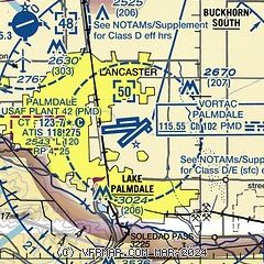
| Sectional chart |
|---|
|
 Download PDF
of official airport diagram from the FAA
| Airport distance calculator |
|---|
|
|
| Sunrise and sunset |
|---|
|
Times for 09-Feb-2026
| | Local
(UTC-8) | | Zulu
(UTC) |
|---|
| Morning civil twilight | | 06:19 | | 14:19 |
| Sunrise | | 06:45 | | 14:45 |
| Sunset | | 17:29 | | 01:29 |
| Evening civil twilight | | 17:55 | | 01:55 |
|
| Current date and time |
|---|
| Zulu (UTC) | 09-Feb-2026 21:17:29 |
|---|
| Local (UTC-8) | 09-Feb-2026 13:17:29 |
|---|
|
| METAR |
|---|
| KPMD | 092053Z AUTO 02008KT 10SM CLR 19/02 A3005 RMK AO2 SLP167 T01890022 58020
|
KWJF
8nm NW | 092056Z AUTO 05009KT 10SM CLR 20/04 A3005 RMK AO2 SLP167 T02000044 56023
|
KEDW
19nm NE | 092055Z 02008KT 40SM SCT200 BKN250 19/03 A3002 RMK AO2A SLP159 T01940031 58020 $
|
|
| TAF |
|---|
| KPMD | 091723Z 0918/1018 VRB03KT P6SM BKN250 FM100000 04005KT P6SM BKN250 FM100500 23006KT P6SM BKN250
|
KWJF
8nm NW | 091723Z 0918/1018 VRB04KT P6SM BKN250 FM092000 05006KT P6SM BKN250 FM100300 31005KT P6SM BKN250 FM100900 VRB03KT P6SM BKN250
|
KEDW
19nm NE | 091400Z 0914/1020 VRB05KT 9999 SCT300 510009 510903 QNH3006INS BECMG 0915/0916 VRB05KT 9999 SCT160 510009 510903 QNH3000INS BECMG 0920/0921 04007KT 9999 SCT160 510009 510903 QNH2999INS BECMG 0921/0922 04007KT 9999 BKN160 510009 510903 QNH2998INS BECMG 0923/0924 VRB05KT 9999 BKN160 510009 510903 QNH2998INS BECMG 1006/1007 VRB05KT 9999 BKN140 510009 510903 QNH2991INS BECMG 1014/1015 VRB05KT 9999 SCT100 OVC140 QNH2991INS TX22/0919Z TN07/0914Z
|
|
| NOTAMs |
|---|
NOTAMs are issued by the DoD/FAA and will open in a separate window not controlled by AirNav.
|
|


