FAA INFORMATION EFFECTIVE 14 MAY 2026
Location
| FAA Identifier: | PUC |
| Lat/Long: | 39-36-50.0000N 110-45-05.8000W
39-36.833333N 110-45.096667W
39.6138889,-110.7516111
(estimated) |
| Elevation: | 5957.6 ft. / 1815.9 m (surveyed) |
| Variation: | 11E (2015) |
| From city: | 3 miles E of PRICE, UT |
| Time zone: | UTC -6 (UTC -7 during Standard Time) |
| Zip code: | 84501 |
Airport Operations
| Airport use: | Open to the public |
| Activation date: | 09/1941 |
| Control tower: | no |
| ARTCC: | SALT LAKE CITY CENTER |
| FSS: | CEDAR CITY FLIGHT SERVICE STATION |
| NOTAMs facility: | PUC (NOTAM-D service available) |
| Attendance: | APRIL-OCT 0800-1800, NOV-MAR MON-SAT 0900-1700 |
| Wind indicator: | yes |
| Segmented circle: | no |
| Lights: | ACTVT MALSF RWY 01; REIL RWY 19, 08 & 26; PAPI RWY 01 & 19, 08 & 26; HIRL RWY 01/19; MIRL RWY 15/33 - CTAF. |
| Beacon: | white-green (lighted land airport)
Operates sunset to sunrise. |
| Landing fee: | yes, 25K LBS $200 RAMP FEE. LNDG FEE WAIVED WITH MNM FUEL PURCHASE. |
Airport Communications
| CTAF/UNICOM: | 122.8 |
| WX ASOS: | 135.425 (435-250-4031) |
- APCH/DEP CTL SVC PRVDD BY SALT LAKE ARTCC (ZLC) ON FREQS 133.9/370.85 (SUNNYSIDE RCAG).
Nearby radio navigation aids
| VOR radial/distance | | VOR name | | Freq | | Var |
|---|
| PUC at field | | CARBON VOR/DME | | 115.50 | | 14E |
Airport Services
| Fuel available: | 100LL JET-A
100LL:24 HR SELF SVC FUEL AVBL WITH CREDIT CARD. |
| Parking: | hangars and tiedowns |
| Airframe service: | MINOR |
| Powerplant service: | MINOR |
| Bottled oxygen: | NONE |
| Bulk oxygen: | NONE |
Runway Information
Runway 1/19
| Dimensions: | 8316 x 100 ft. / 2535 x 30 m |
| Surface: | asphalt/grooved, in excellent condition |
| Weight bearing capacity: | | PCN 18 /F/B/X/U | | Single wheel: | 30.0 | | Double wheel: | 40.0 |
|
| Runway edge lights: | high intensity |
| RUNWAY 1 | | RUNWAY 19 |
| Latitude: | 39-36.295258N | | 39-37.594780N |
| Longitude: | 110-45.312835W | | 110-44.755285W |
| Elevation: | 5811.7 ft. | | 5957.6 ft. |
| Traffic pattern: | left | | left |
| Runway heading: | 007 magnetic, 018 true | | 187 magnetic, 198 true |
| Markings: | precision, in good condition | | basic, in good condition |
| Visual slope indicator: | 4-light PAPI on left (3.00 degrees glide path) | | 2-light PAPI on left (4.00 degrees glide path)
PAPI UNUSBL BYD 3 NM DUE TO TRRN; BYD 9 DEGS RIGHT OF CNTRLN. |
| Approach lights: | MALSF: 1,400 foot medium intensity approach lighting system with sequenced flashers | | |
| Runway end identifier lights: | | | yes |
| Touchdown point: | yes, no lights | | yes, no lights |
| Instrument approach: | ILS/DME | | |
Runway 15/33
| Dimensions: | 4513 x 75 ft. / 1376 x 23 m |
| Surface: | asphalt, in fair condition |
| Weight bearing capacity: | | PCN 13 /F/B/X/U | | Single wheel: | 13.0 |
|
| Runway edge lights: | medium intensity |
| RUNWAY 15 | | RUNWAY 33 |
| Latitude: | 39-36.922903N | | 39-36.230587N |
| Longitude: | 110-45.404100W | | 110-45.055250W |
| Elevation: | 5860.6 ft. | | 5812.6 ft. |
| Traffic pattern: | left | | left |
| Runway heading: | 147 magnetic, 158 true | | 327 magnetic, 338 true |
| Markings: | basic, in fair condition | | basic, in fair condition |
| Touchdown point: | yes, no lights | | yes, no lights |
| Obstructions: | none | | road, 20:1 slope to clear |
Runway 8/26
| Dimensions: | 3151 x 75 ft. / 960 x 23 m |
| Surface: | asphalt, in good condition |
| Weight bearing capacity: | | PCN 3 /F/B/Z/U | | Single wheel: | 12.5 |
|
| RUNWAY 8 | | RUNWAY 26 |
| Latitude: | 39-36.907865N | | 39-36.909125N |
| Longitude: | 110-45.402610W | | 110-44.731680W |
| Elevation: | 5859.3 ft. | | 5890.5 ft. |
| Traffic pattern: | left | | left |
| Runway heading: | 079 magnetic, 090 true | | 259 magnetic, 270 true |
| Displaced threshold: | 128 ft. | | no |
| Markings: | basic, in good condition | | basic, in good condition |
| Visual slope indicator: | 2-light PAPI on left (3.00 degrees glide path) | | 2-light PAPI on left (3.00 degrees glide path) |
| Runway end identifier lights: | yes | | yes |
| Touchdown point: | yes, no lights | | yes, no lights |
| Obstructions: | none | | road, 18:1 slope to clear |
Airport Ownership and Management from official FAA records
| Ownership: | Publicly-owned |
| Owner: | CARBON COUNTY
751 E 100 N
PRICE, UT 84501
Phone 435-636-3201 |
| Manager: | DOUG BULLOCK
3095 AIRPORT ROAD, 3095 EAST AIRPORT ROAD
PRICE, UT 84501
Phone 205-910-7989 |
Additional Remarks
| A52-19 | HIGH VOLTAGE TRANS LINE ON EXTDD CNTRLN. |
| - | FOR CD IF UNA TO CTC ON FSS FREQ, CTC SALT LAKE ARTCC AT 801-320-2568. |
| - | RWY 15, 20 FT DROP OFF, 200 FT FM THLD. |
| - | RWY 08, 60 FT DROP OFF, 520 FT FM RWY END. |
Instrument Procedures
NOTE: All procedures below are presented as PDF files. If you need a reader for these files, you should download the free Adobe Reader.NOT FOR NAVIGATION. Please procure official charts for flight.
FAA instrument procedures published for use from 14 May 2026 at 0901Z to 11 June 2026 at 0900Z.
IAPs - Instrument Approach Procedures |
|---|
| ILS OR LOC RWY 01 | |
download (434KB) |
| RNAV (GPS) RWY 01 | |
download (301KB) |
| NOTE: Special Alternate Minimums apply | |
download (119KB) |
| NOTE: Special Take-Off Minimums/Departure Procedures apply | |
download (349KB) |
Other nearby airports with instrument procedures:
69V - Huntington Municipal Airport (17 nm SW)
U69 - Duchesne Municipal Airport (39 nm NE)
41U - Sanpete County Regional Airport (43 nm SW)
U34 - Green River Municipal Airport (46 nm SE)
74V - Roosevelt Municipal Airport (51 nm NE)
|
|

Road maps at:
MapQuest
Bing
Google
| Aerial photo |
|---|
WARNING: Photo may not be current or correct
 Photo by Cameron Nelson
Photo taken 25-Aug-2012
looking northwest.
Photo by Cameron Nelson
Photo taken 25-Aug-2012
looking northwest.
Do you have a better or more recent aerial photo of Carbon County Regional Airport/Buck Davis Field that you would like to share? If so, please send us your photo.
|
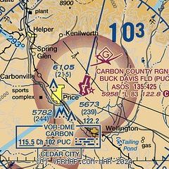
| Sectional chart |
|---|
|
CAUTION: Diagram may not be current

| Airport distance calculator |
|---|
|
|
| Sunrise and sunset |
|---|
|
Times for 19-May-2026
| | Local
(UTC-6) | | Zulu
(UTC) |
|---|
| Morning civil twilight | | 05:35 | | 11:35 |
| Sunrise | | 06:06 | | 12:06 |
| Sunset | | 20:33 | | 02:33 |
| Evening civil twilight | | 21:04 | | 03:04 |
|
| Current date and time |
|---|
| Zulu (UTC) | 20-May-2026 01:02:16 |
|---|
| Local (UTC-6) | 19-May-2026 19:02:16 |
|---|
|
| METAR |
|---|
| KPUC | 200053Z AUTO 31007KT 10SM BKN100 13/M07 A3013 RMK AO2 SLP192 T01331067 $
|
|
| NOTAMs |
|---|
NOTAMs are issued by the DoD/FAA and will open in a separate window not controlled by AirNav.
|
|


