FAA INFORMATION EFFECTIVE 09 JULY 2026
Location
| FAA Identifier: | RYN |
| Lat/Long: | 32-08-31.9600N 111-10-28.4850W
32-08.532667N 111-10.474750W
32.1422111,-111.1745792
(estimated) |
| Elevation: | 2418.9 ft. / 737.3 m (surveyed) |
| Variation: | 12E (1985) |
| From city: | 10 miles SW of TUCSON, AZ |
| Time zone: | UTC -7 (year round; does not observe DST) |
| Zip code: | 85735 |
Airport Operations
| Airport use: | Open to the public |
| Activation date: | 03/1943 |
| Control tower: | yes |
| ARTCC: | ALBUQUERQUE CENTER |
| FSS: | PRESCOTT FLIGHT SERVICE STATION |
| NOTAMs facility: | PRC (NOTAM-D service available) |
| Attendance: | M-F 0800-1700, ALL SAT 0800-1700 |
| Pattern altitude: | 3218.9 ft. MSL |
| Wind indicator: | lighted |
| Segmented circle: | yes |
| Lights: | WHEN ATCT CLSD ACTVT PAPI RWY 06R, 06L, & 24R; VASI RWY 24L; MIRL RWY 06R/24L & 15/33 - CTAF. |
| Beacon: | white-green (lighted land airport)
Operates sunset to sunrise. |
Airport Communications
| CTAF: | 125.8 |
| ATIS: | 133.35 |
| WX AWOS-3: | PHONE 520-578-0269 |
| RYAN GROUND: | 118.2 [0600-2000] |
| RYAN TOWER: | 125.8 120.35 [0600-2000] |
| TUCSON APPROACH: | 273.6 128.5 |
| TUCSON DEPARTURE: | 273.6 128.5 |
| WX ASOS at TUS (12 nm E): | PHONE 520-355-5542 |
| WX AWOS-3 at AVQ (16 nm N): | 118.375 (520-682-1397) |
- (TRACON_ID) U90 APCH/P & DEP/P FREQ 273.6.
- TWR FREQ WILL BE 125.8 FOR ALL RWYS EXC RWY 06L/24R WHEN STATED ON THE ATIS.
Nearby radio navigation aids
| VOR radial/distance | | VOR name | | Freq | | Var |
|---|
| TUSr270/13.5 | | TUCSON VORTAC | | 116.00 | | 12E |
| NDB name | | Hdg/Dist | | Freq | | Var | | ID |
|---|
| RYAN | | at field | | 338 | | 12E | | RYN | .-. -.-- -. |
| ROBLES | | 055/10.3 | | 220 | | 12E | | RBJ | .-. -... .--- |
Airport Services
| Fuel available: | 100LL JET-A
100LL:SELF SVC H24 WITH CREDIT CARD.
A:0800-1700; AFT HR SVC FEE - 520-744-7474. |
| Parking: | tiedowns |
| Airframe service: | MAJOR |
| Powerplant service: | MAJOR |
Runway Information
Runway 6R/24L
| Dimensions: | 5500 x 75 ft. / 1676 x 23 m |
| Surface: | asphalt, in good condition |
| Weight bearing capacity: | | Single wheel: | 12.5 | | Double wheel: | 30.0 |
|
| Runway edge lights: | medium intensity |
| RUNWAY 6R | | RUNWAY 24L |
| Latitude: | 32-08.409085N | | 32-08.714527N |
| Longitude: | 111-10.757957W | | 111-09.754213W |
| Elevation: | 2398.7 ft. | | 2403.0 ft. |
| Traffic pattern: | right | | left |
| Runway heading: | 058 magnetic, 070 true | | 238 magnetic, 250 true |
| Markings: | precision, in good condition | | basic, in good condition |
| Visual slope indicator: | 4-light PAPI on left (3.00 degrees glide path) | | 4-box VASI on left (3.00 degrees glide path) |
| Runway end identifier lights: | yes | | |
| Touchdown point: | yes, no lights | | yes, no lights |
| Instrument approach: | ILS | | |
Runway 6L/24R
| Dimensions: | 4900 x 75 ft. / 1494 x 23 m |
| Surface: | asphalt, in good condition |
| Weight bearing capacity: | | Single wheel: | 12.5 | | Double wheel: | 30.0 |
|
| Runway edge lights: | medium intensity |
| Operational restrictions: | CLSD WHEN ATCT CLSD. |
| RUNWAY 6L | | RUNWAY 24R |
| Latitude: | 32-08.473303N | | 32-08.745550N |
| Longitude: | 111-10.949657W | | 111-10.055465W |
| Elevation: | 2393.1 ft. | | 2396.4 ft. |
| Traffic pattern: | left | | right |
| Runway heading: | 058 magnetic, 070 true | | 238 magnetic, 250 true |
| Markings: | basic, in good condition | | basic, in good condition |
| Visual slope indicator: | 4-light PAPI on left (3.00 degrees glide path) | | 4-light PAPI on left (3.00 degrees glide path)
PAPI UNUSBL BYD 4.9 NM. |
| Runway end identifier lights: | yes | | |
| Touchdown point: | yes, no lights | | yes, no lights |
Runway 15/33
| Dimensions: | 4010 x 75 ft. / 1222 x 23 m |
| Surface: | asphalt, in fair condition |
| Runway edge lights: | medium intensity |
| RUNWAY 15 | | RUNWAY 33 |
| Latitude: | 32-08.722177N | | 32-08.075478N |
| Longitude: | 111-10.821577W | | 111-10.659795W |
| Elevation: | 2386.7 ft. | | 2418.8 ft. |
| Traffic pattern: | right | | left |
| Runway heading: | 156 magnetic, 168 true | | 336 magnetic, 348 true |
| Markings: | basic, in good condition | | basic, in good condition |
| Runway end identifier lights: | no | | |
| Touchdown point: | yes, no lights | | yes, no lights |
Airport Ownership and Management from official FAA records
| Ownership: | Publicly-owned |
| Owner: | CITY OF TUCSON ARPT AUTHORITY
7250 S. TUCSON BLVD. SUITE 300
TUCSON, AZ 85756
Phone 520-573-8100 |
| Manager: | DANETTE BEWLEY
7250 S. TUCSON BLVD, SUITE 300
TUCSON, AZ 85756
Phone 520-573-8100
520-245-5766; 520-573-8188/8179/8108. |
Additional Remarks
| A30A-06R | FQT ILS PRACTICE APCHS. |
| - | RWY 06L & 06R CALM WIND RWY; AFTN WIND MAY FAVOR RWY 24L & 24R. |
| - | USE LNDG LGTS IN PAT. |
| - | FOR CD WHEN ATCT IS CLSD CTC TUCSON APCH AT 520-829-6121. |
Instrument Procedures
NOTE: All procedures below are presented as PDF files. If you need a reader for these files, you should download the free Adobe Reader.NOT FOR NAVIGATION. Please procure official charts for flight.
FAA instrument procedures published for use from 09 July 2026 at 0901Z to 06 August 2026 at 0900Z.
IAPs - Instrument Approach Procedures |
|---|
| ILS OR LOC RWY 06R | |
download (296KB) |
| RNAV (GPS) RWY 06R | |
download (262KB) |
| NOTE: Special Alternate Minimums apply | |
download (118KB) |
|
|---|
| ALMON ONE (OBSTACLE) (RNAV) | |
download (173KB) |
| NOTE: Special Take-Off Minimums/Departure Procedures apply | |
download (348KB) |
Other nearby airports with instrument procedures:
KTUS - Tucson International Airport (12 nm E)
KDMA - Davis Monthan Air Force Base (15 nm E)
KAVQ - Marana Regional Airport (16 nm N)
KOLS - Nogales International Airport (47 nm S)
P08 - Coolidge Municipal Airport (49 nm N)
|
|

Road maps at:
MapQuest
Bing
Google
| Aerial photo |
|---|
WARNING: Photo may not be current or correct
 Photo by Trent Thomas
Photo taken 13-Aug-2018
looking northeast, 7,500 feet.
Photo by Trent Thomas
Photo taken 13-Aug-2018
looking northeast, 7,500 feet.
Do you have a better or more recent aerial photo of Ryan Field Airport that you would like to share? If so, please send us your photo.
|
| Sectional chart |
|---|
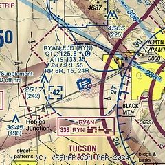
|
 Download PDF
of official airport diagram from the FAA
| Airport distance calculator |
|---|
|
|
| Sunrise and sunset |
|---|
|
Times for 30-Jul-2026
| | Local
(UTC-7) | | Zulu
(UTC) |
|---|
| Morning civil twilight | | 05:13 | | 12:13 |
| Sunrise | | 05:39 | | 12:39 |
| Sunset | | 19:23 | | 02:23 |
| Evening civil twilight | | 19:50 | | 02:50 |
|
| Current date and time |
|---|
| Zulu (UTC) | 30-Jul-2026 15:33:12 |
|---|
| Local (UTC-7) | 30-Jul-2026 08:33:12 |
|---|
|
| METAR |
|---|
| KRYN | 301445Z 08006KT 10SM CLR 32/14 A2997
|
KTUS
11nm E | 301453Z 17003KT 10SM CLR 31/17 A3002 RMK AO2 SLP107 T03060167 51012 $
|
KDMA
16nm E | 301455Z AUTO 13006KT 10SM BKN190 BKN210 32/16 A3001 RMK AO2 SLP151 T03180157 52012 TSNO $
|
KAVQ
16nm N | 301515Z AUTO 16003KT 10SM CLR 34/13 A2995 RMK AO2
|
|
| TAF |
|---|
KTUS
11nm E | 301126Z 3012/3112 14006KT P6SM SCT200 FM301600 32008KT P6SM FEW120 SCT180 FM310500 18008KT P6SM FEW120 SCT200
|
KDMA
16nm E | 301100Z 3011/3117 15009KT 9999 FEW070 QNH3000INS BECMG 3017/3018 31009KT 9999 SCT150 QNH3000INS TEMPO 3022/3102 34012G20KT BECMG 3103/3104 20009KT 9999 SCT130 QNH2993INS TX41/3022Z TN29/3012Z
|
|
| NOTAMs |
|---|
NOTAMs are issued by the DoD/FAA and will open in a separate window not controlled by AirNav.
|
|


