FAA INFORMATION EFFECTIVE 16 APRIL 2026
Location
| FAA Identifier: | U74 |
| Lat/Long: | 40-24-57.4000N 116-33-48.6000W
40-24.956667N 116-33.810000W
40.4159444,-116.5635000
(estimated) |
| Elevation: | 4790.8 ft. / 1460.2 m (surveyed) |
| Variation: | 16E (1985) |
| From city: | 1 mile E of CRESCENT VALLEY, NV |
| Time zone: | UTC -7 (UTC -8 during Standard Time) |
| Zip code: | 89821 |
Airport Operations
| Airport use: | Open to the public |
| Activation date: | 09/1964 |
| Control tower: | no |
| ARTCC: | SALT LAKE CITY CENTER |
| FSS: | RENO FLIGHT SERVICE STATION |
| NOTAMs facility: | RNO (NOTAM-D service available) |
| Attendance: | UNATNDD |
| Wind indicator: | yes |
| Segmented circle: | no |
Airport Communications
| CTAF: | 122.9 |
| WX AWOS-3 at BAM (18 nm NW): | 119.45 (775-635-8419) |
Nearby radio navigation aids
| VOR radial/distance | | VOR name | | Freq | | Var |
|---|
| BAMr106/18.8 | | BATTLE MOUNTAIN VORTAC | | 112.20 | | 13E |
Airport Services
Runway Information
Runway 5/23
| Dimensions: | 5424 x 60 ft. / 1653 x 18 m |
| Surface: | dirt, in poor condition
EAST 3000 FEET OF RWY 23 SOFT WITH LATERAL RIVULET/DITCHES 6-10 INCHES DEEP. |
| RUNWAY 5 | | RUNWAY 23 |
| Latitude: | 40-24.975622N | | 40-25.285422N |
| Longitude: | 116-34.229017W | | 116-33.133180W |
| Elevation: | 4790.8 ft. | | 4746.8 ft. |
| Traffic pattern: | left | | left |
| Markings: | none, in poor condition | | none, in poor condition |
| Touchdown point: | yes, no lights | | yes, no lights |
| Obstructions: | 17 ft. road, 35 ft. from runway, 2:1 slope to clear | | 15 ft. road, 30 ft. from runway, 2:1 slope to clear |
Runway 14/32
| Dimensions: | 4650 x 75 ft. / 1417 x 23 m |
| Surface: | dirt, in poor condition
WEEDS CVR OVER 1/2 THE RWY SFC. |
| RUNWAY 14 | | RUNWAY 32 |
| Latitude: | 40-25.092398N | | 40-24.415847N |
| Longitude: | 116-34.194628W | | 116-33.725527W |
| Elevation: | 4787.7 ft. | | 4762.0 ft. |
| Traffic pattern: | left | | left |
| Runway heading: | 136 magnetic, 152 true | | 316 magnetic, 332 true |
| Markings: | none, in poor condition | | none, in poor condition |
| Touchdown point: | yes, no lights | | yes, no lights |
| Obstructions: | 60 ft. tree, 675 ft. from runway, 100 ft. right of centerline, 11:1 slope to clear | | none |
Airport Ownership and Management from official FAA records
| Ownership: | Publicly-owned |
| Owner: | U.S. DEPT OF THE INTERIOR
P.O. BOX 12000
RENO, NV 89520
Phone 775-861-6400 |
| Manager: | JEB ROWLEY
701 S MAIN STREET, PO BOX 714
EUREKA, NV 89316
Phone (775) 237-5372 |
Additional Remarks
| - | UNCONTROLLED VEHICLE ACES ALL RWYS. |
| - | CATTLE ON & INVOF RWYS. |
| - | RWY 14/32 - 2 FT EARTH RIDGES ALG RWY EDGES AND 3 FT BERM ALG BOTH SIDES 0F RWY. |
| - | RWY 05/23 - 1 FT DRAINAGE DITCH BOTH SIDES OF RWY AND 2 FT EARTH RIDGES ALG RWY EDGES. |
| - | RWY 05/23 - FIRST 1600 FT OF RWY ROUGH SFC. |
| - | FOR CD CTC SALT LAKE ARTCC AT 801-320-2568. |
Instrument Procedures
There are no published instrument procedures at U74.
Some nearby airports with instrument procedures:
KBAM - Battle Mountain Airport (18 nm NW)
KEKO - Elko Regional Airport (43 nm NE)
05U - Eureka Airport (55 nm SE)
KWMC - Winnemucca Municipal Airport (63 nm NW)
10U - Owyhee Airport (94 nm N)
|
|

Road maps at:
MapQuest
Bing
Google
| Aerial photo |
|---|
WARNING: Photo may not be current or correct
 Photo taken 25-Sep-2011
looking west towards town.
Photo taken 25-Sep-2011
looking west towards town.
Do you have a better or more recent aerial photo of Crescent Valley Airport that you would like to share? If so, please send us your photo.
|
| Sectional chart |
|---|
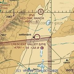
|
| Airport distance calculator |
|---|
|
|
| Sunrise and sunset |
|---|
|
Times for 04-May-2026
| | Local
(UTC-7) | | Zulu
(UTC) |
|---|
| Morning civil twilight | | 05:13 | | 12:13 |
| Sunrise | | 05:43 | | 12:43 |
| Sunset | | 19:43 | | 02:43 |
| Evening civil twilight | | 20:13 | | 03:13 |
|
| Current date and time |
|---|
| Zulu (UTC) | 04-May-2026 10:13:30 |
|---|
| Local (UTC-7) | 04-May-2026 03:13:30 |
|---|
|
| METAR |
|---|
KBAM
18nm NW | 040955Z AUTO 20003KT 10SM CLR 07/M01 A2985 RMK AO1
|
|
| TAF |
|---|
KBAM
18nm NW | 040520Z 0406/0506 22005KT P6SM BKN120 FM042100 VRB06KT P6SM VCSH BKN110 PROB30 0421/0501 -TSRA BKN090CB FM050100 16010G20KT P6SM -SHRA OVC090 FM050300 17007KT P6SM VCSH BKN100
|
|
| NOTAMs |
|---|
NOTAMs are issued by the DoD/FAA and will open in a separate window not controlled by AirNav.
|
|

