FAA INFORMATION EFFECTIVE 09 JULY 2026
Location
| FAA Identifier: | VCT |
| Lat/Long: | 28-51-15.1400N 096-55-07.4340W
28-51.252333N 096-55.123900W
28.8542056,-96.9187317
(estimated) |
| Elevation: | 115.1 ft. / 35.1 m (surveyed) |
| Variation: | 04E (2010) |
| From city: | 5 miles NE of VICTORIA, TX |
| Time zone: | UTC -5 (UTC -6 during Standard Time) |
| Zip code: | 77904 |
Airport Operations
| Airport use: | Open to the public |
| Activation date: | 12/1941 |
| Control tower: | yes |
| ARTCC: | HOUSTON CENTER |
| FSS: | MONTGOMERY COUNTY FLIGHT SERVICE STATION |
| NOTAMs facility: | VCT (NOTAM-D service available) |
| Attendance: | MON-FRI 0600-2100 |
| Pattern altitude: | TPA FOR JETS 1600 FT; FOR TURBO PROP, LIGHT AIRCRAFT, ROTORCRAFT 1100 FT AGL |
| Wind indicator: | lighted |
| Segmented circle: | yes |
| Lights: | HIRL RWY 13/31 PRESET LOW INTST, TO INCR INTST & ACTVT MALSR RWY 13 - CTAF. MIRL RWY 18/36 PRESET MED INTST ONLY. PAPI RWYS 31, 18 & 36 OPR CONSLY. |
| Beacon: | white-green (lighted land airport)
Operates sunset to sunrise. |
| Fire and rescue: | ARFF index A |
| Airline operations: | BETWEEN 2200-0700 ALL UNSCHEDULED ACR OPNS WITH MORE THAN 9 PSGR SEATS CONTACT ARFF 361-582-5889. |
Airport Communications
| CTAF: | 126.075 |
| UNICOM: | 122.7 |
| ATIS: | 119.025 |
| WX ASOS: | PHONE 361-433-5979 |
| VICTORIA GROUND: | 120.525 239.25 [0700-2200] |
| VICTORIA TOWER: | 126.075 257.95 [0700-2200] |
| WX AWOS-3PT at PKV (17 nm SE): | 118.275 (361-552-3060) |
- APCH/DEP CTL SVC PRVDD BY HOUSTON ARTCC (ZHU) ON FREQS 135.05/353.6 (VICTORIA RCAG).
Nearby radio navigation aids
| VOR radial/distance | | VOR name | | Freq | | Var |
|---|
| VCTr125/4.2 | | VICTORIA VOR/DME | | 109.00 | | 06E |
| PSXr271/32.7 | | PALACIOS VORTAC | | 117.30 | | 08E |
Airport Services
| Fuel available: | 100LL JET-A |
| Parking: | hangars and tiedowns |
| Airframe service: | MINOR |
| Powerplant service: | MINOR |
Runway Information
Runway 13/31
| Dimensions: | 9111 x 150 ft. / 2777 x 46 m |
| Surface: | asphalt/grooved, in fair condition |
| Weight bearing capacity: | | Single wheel: | 28.0 | | Double wheel: | 49.0 | | Double tandem: | 87.0 |
|
| Runway edge lights: | high intensity |
| RUNWAY 13 | | RUNWAY 31 |
| Latitude: | 28-51.825022N | | 28-50.810247N |
| Longitude: | 096-56.044665W | | 096-54.784745W |
| Elevation: | 115.1 ft. | | 103.4 ft. |
| Traffic pattern: | left | | right |
| Runway heading: | 128 magnetic, 132 true | | 308 magnetic, 312 true |
| Declared distances: | TORA:9111 TODA:9111 ASDA:9111 LDA:9111 | | TORA:9111 TODA:9111 ASDA:9111 LDA:9111 |
| Markings: | precision, in good condition | | nonprecision, in good condition |
| Visual slope indicator: | | | 4-light PAPI on left (3.00 degrees glide path) |
| Approach lights: | MALSR: 1,400 foot medium intensity approach lighting system with runway alignment indicator lights | | |
| Touchdown point: | yes, no lights | | yes, no lights |
| Instrument approach: | ILS/DME | | |
Runway 18/36
| Dimensions: | 4908 x 75 ft. / 1496 x 23 m |
| Surface: | asphalt/grooved, in good condition |
| Weight bearing capacity: | | Single wheel: | 28.0 | | Double wheel: | 49.0 | | Double tandem: | 87.0 |
|
| Runway edge lights: | medium intensity |
| RUNWAY 18 | | RUNWAY 36 |
| Latitude: | 28-51.536015N | | 28-50.726122N |
| Longitude: | 096-54.585255W | | 096-54.583172W |
| Elevation: | 106.3 ft. | | 102.8 ft. |
| Traffic pattern: | left | | left |
| Runway heading: | 176 magnetic, 180 true | | 356 magnetic, 360 true |
| Declared distances: | TORA:4908 TODA:4908 ASDA:4908 LDA:4908 | | TORA:4908 TODA:4908 ASDA:4908 LDA:4908 |
| Markings: | basic, in good condition | | basic, in good condition |
| Visual slope indicator: | 2-light PAPI on left (3.00 degrees glide path) | | 2-light PAPI on left (3.00 degrees glide path) |
| Runway end identifier lights: | yes
REIL OTS INDEFLY. | | yes
REIL OTS INDEFLY. |
| Touchdown point: | yes, no lights | | yes, no lights |
| Obstructions: | 6 ft. fence, 400 ft. from runway, 33:1 slope to clear | | 29 ft. pole, 1544 ft. from runway, 44 ft. left of centerline, 46:1 slope to clear |
Helipad H1
| Dimensions: | 60 x 60 ft. / 18 x 18 m |
| Surface: | asphalt, in good condition |
| Latitude: | 28-50.633333N | | |
| Longitude: | 096-55.040500W | | |
| Elevation: | 115.0 ft. | | |
| Traffic pattern: | left | | left |
| Markings: | basic, in good condition | | |
Airport Ownership and Management from official FAA records
| Ownership: | Publicly-owned |
| Owner: | COUNTY OF VICTORIA
VICTORIA CO COURTHOUSE RM 102
VICTORIA, TX 77901
Phone 361-575-4558 |
| Manager: | V. LENNY LLERENA
609 FOSTER FIELD DR SUITE F
VICTORIA, TX 77904
Phone 361-578-2704 |
Additional Remarks
| A39-18/36 | PCR VALUE: 130/R/A/W/T |
| A39-13/31 | PCR VALUE: 610/F/D/X/T |
| - | FOR CD IF UNA TO CTC ON FSS FREQ, CTC HOUSTON ARTCC AT 281-230-5622. |
| - | AD AP BIRD ACT |
Instrument Procedures
NOTE: All procedures below are presented as PDF files. If you need a reader for these files, you should download the free Adobe Reader.NOT FOR NAVIGATION. Please procure official charts for flight.
FAA instrument procedures published for use from 09 July 2026 at 0901Z to 06 August 2026 at 0900Z.
IAPs - Instrument Approach Procedures |
|---|
| ILS OR LOC RWY 13 | |
download (251KB) |
| RNAV (GPS) RWY 13 | |
download (213KB) |
| RNAV (GPS) RWY 31 | |
download (220KB) |
| VOR RWY 13 | |
download (188KB) |
| VOR RWY 31 | |
download (180KB) |
| NOTE: Special Alternate Minimums apply | |
download (126KB) |
| NOTE: Special Take-Off Minimums/Departure Procedures apply | |
download (210KB) |
Other nearby airports with instrument procedures:
KPKV - Calhoun County Airport (17 nm SE)
26R - Jackson County Airport (20 nm NE)
T85 - Yoakum Municipal Airport (30 nm NW)
KPSX - Palacios Municipal Airport (36 nm E)
KNGT - Goliad Naval Outlying Field (39 nm W)
|
|

Road maps at:
MapQuest
Bing
Google
| Aerial photo |
|---|
WARNING: Photo may not be current or correct

Do you have a better or more recent aerial photo of Victoria Regional Airport that you would like to share? If so, please send us your photo.
|
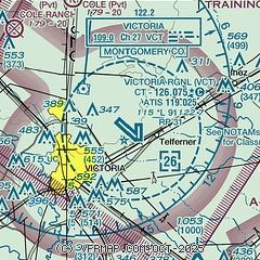
| Sectional chart |
|---|
|
CAUTION: Diagram may not be current

| Airport distance calculator |
|---|
|
|
| Sunrise and sunset |
|---|
|
Times for 27-Jul-2026
| | Local
(UTC-5) | | Zulu
(UTC) |
|---|
| Morning civil twilight | | 06:21 | | 11:21 |
| Sunrise | | 06:47 | | 11:47 |
| Sunset | | 20:21 | | 01:21 |
| Evening civil twilight | | 20:47 | | 01:47 |
|
| Current date and time |
|---|
| Zulu (UTC) | 27-Jul-2026 06:08:46 |
|---|
| Local (UTC-5) | 27-Jul-2026 01:08:46 |
|---|
|
| METAR |
|---|
| KVCT | 270551Z AUTO 18005KT 10SM CLR 26/24 A2999 RMK AO2 SLP155 T02560244 10328 20256 403560233 50005
|
KPKV
17nm SE | 270555Z AUTO 17005KT 10SM CLR 26/26 A2997 RMK AO2 T02580258 10314 20256 403470242 50005
|
|
| TAF |
|---|
| KVCT | 261721Z 2618/2718 17010KT P6SM SCT035 FM270300 18005KT P6SM FEW020 TEMPO 2710/2713 3SM BR BKN018
|
|
| NOTAMs |
|---|
NOTAMs are issued by the DoD/FAA and will open in a separate window not controlled by AirNav.
|
|


