FAA INFORMATION EFFECTIVE 14 MAY 2026
Location
| FAA Identifier: | X09 |
| Lat/Long: | 29-41-24.3000N 095-50-25.7050W
29-41.405000N 095-50.428417W
29.6900833,-95.8404736
(estimated) |
| Elevation: | 130 ft. / 40 m (estimated) |
| Variation: | 06E (1985) |
| From city: | 3 miles E of FULSHEAR, TX |
| Time zone: | UTC -5 (UTC -6 during Standard Time) |
| Zip code: | 77406 |
Airport Operations
| Airport use: | Open to the public |
| Activation date: | 04/1979 |
| Control tower: | no |
| ARTCC: | HOUSTON CENTER |
| FSS: | MONTGOMERY COUNTY FLIGHT SERVICE STATION |
| NOTAMs facility: | CXO (NOTAM-D service available) |
| Attendance: | UNATNDD |
| Wind indicator: | lighted |
| Segmented circle: | no |
| Lights: | DUSK-2200. ACTVT LIRL RWY 17/35 AFT 2200 - CTAF. |
| Beacon: | white-green (lighted land airport)
RTG BCN DUSK-2200. |
| Landing fee: | yes |
Airport Communications
| CTAF/UNICOM: | 122.725 |
| WX AWOS-3 at TME (8 nm NW): | 119.525 (281-574-7296) |
| WX ASOS at SGR (10 nm SE): | 118.125 (281-242-7605) |
Nearby radio navigation aids
| VOR radial/distance | | VOR name | | Freq | | Var |
|---|
| IAHr233/30.3 | | HUMBLE VORTAC | | 116.60 | | 05E |
| TNVr155/37.6 | | NAVASOTA VOR/DME | | 115.90 | | 08E |
Airport Services
Runway Information
Runway 17/35
| Dimensions: | 3352 x 100 ft. / 1022 x 30 m |
| Surface: | turf, in good condition
SOFT AREAS, UNRETRACTED SPRINKLER HEADS ON RWY. |
| Runway edge lights: | non-standard
NSTD LIRL; 2800 FT OF RWY LGTD AT NIGHT BTN DSPLCD THLDS. |
| RUNWAY 17 | | RUNWAY 35 |
| Latitude: | 29-41.681333N | | 29-41.128667N |
| Longitude: | 095-50.439500W | | 095-50.417333W |
| Elevation: | 130.0 ft. | | 130.0 ft. |
| Traffic pattern: | left | | left |
| Runway heading: | 172 magnetic, 178 true | | 352 magnetic, 358 true |
| Displaced threshold: | 315 ft. | | 250 ft. |
| Markings: | none, in good condition | | none, in good condition |
| Visual slope indicator: | 2-box VASI on left | | |
| Touchdown point: | yes, no lights | | yes, no lights |
| Obstructions: | 45 ft. tree, marked, 100 ft. left of centerline
APCH SLOPE 7:1 TO DSPLCD THR OVR 33 FT TREE 115 FT FM DSPLCD THR 96 FT LEFT. | | 33 ft. tree, 95 ft. right of centerline
APCH SLOPE 7:1 TO DSPLCD THR. |
Airport Ownership and Management from official FAA records
| Ownership: | Privately-owned |
| Owner: | COVEY TRAILS CIVIC CLUB INC
10CC KITTY HAWK WEST
RICHMOND, TX 77406
Phone 910-754-2710
CHRIS MALLORY, PRESIDENT, COVEY TRAILS CIVIC CLUB. |
| Manager: | GRANVILLE LASSETER II
10 WEST KITTY HAWK
RICHMOND, TX 77406
Phone 281-685-7540 |
Additional Remarks
| - | BASE LEGS AND TURNS TO FINAL APCH MUST BE WITHIN .75 NM OF THE RWY ENDS. |
| - | FOR CD CTC HOUSTON APCH AT 281-443-5844 TO CNL IFR CALL 281-443-5888. |
| - | CELL TWR, 1.5 MILES SOUTH OF RWY 17 END. |
| - | STUDENT TNG PROHIBITED. |
Instrument Procedures
There are no published instrument procedures at X09.
Some nearby airports with instrument procedures:
KTME - Houston Executive Airport (8 nm NW)
KSGR - Sugar Land Regional Airport (10 nm SE)
KIWS - West Houston Airport (12 nm NE)
KAXH - Houston Southwest Airport (22 nm SE)
KELA - Eagle Lake Airport (26 nm W)
|
|

Road maps at:
MapQuest
Bing
Google
| Aerial photo |
|---|
WARNING: Photo may not be current or correct

Do you have a better or more recent aerial photo of Covey Trails Airport that you would like to share? If so, please send us your photo.
|
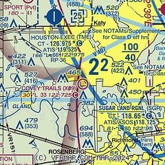
| Sectional chart |
|---|
|
| Airport distance calculator |
|---|
|
|
| Sunrise and sunset |
|---|
|
Times for 15-May-2026
| | Local
(UTC-5) | | Zulu
(UTC) |
|---|
| Morning civil twilight | | 06:05 | | 11:05 |
| Sunrise | | 06:31 | | 11:31 |
| Sunset | | 20:08 | | 01:08 |
| Evening civil twilight | | 20:34 | | 01:34 |
|
| Current date and time |
|---|
| Zulu (UTC) | 15-May-2026 23:40:19 |
|---|
| Local (UTC-5) | 15-May-2026 18:40:19 |
|---|
|
| METAR |
|---|
KTME
8nm NW | 152315Z AUTO 19012KT 10SM CLR 29/21 A2992 RMK AO2
|
KSGR
11nm SE | 152253Z 17013KT 10SM CLR 28/21 A2991 RMK AO2 SLP131 T02780206
|
|
| TAF |
|---|
KSGR
11nm SE | 151720Z 1518/1618 18014G22KT P6SM SCT035 FM160200 15011KT P6SM SCT030 BKN200 FM160800 16007KT P6SM SCT020 BKN200 FM161500 16015G25KT P6SM SCT030 SCT250
|
|
| NOTAMs |
|---|
NOTAMs are issued by the DoD/FAA and will open in a separate window not controlled by AirNav.
|
|

