FAA INFORMATION EFFECTIVE 25 DECEMBER 2025
Location
| FAA Identifier: | ZER |
| Lat/Long: | 40-42-24.3030N 076-22-25.5010W
40-42.405050N 076-22.425017W
40.7067508,-76.3737503
(estimated) |
| Elevation: | 1729.8 ft. / 527.2 m (surveyed) |
| Variation: | 12W (2000) |
| From city: | 8 miles W of POTTSVILLE, PA |
| Time zone: | UTC -5 (UTC -4 during Daylight Saving Time) |
| Zip code: | 17921 |
Airport Operations
| Airport use: | Open to the public |
| Activation date: | 10/1959 |
| Control tower: | no |
| ARTCC: | NEW YORK CENTER |
| FSS: | WILLIAMSPORT FLIGHT SERVICE STATION |
| NOTAMs facility: | IPT (NOTAM-D service available) |
| Attendance: | MON-FRI 0730-1700, ALL SAT - SUN ON CALL
FOR SVC AFTER HRS 570-617-6002. |
| Wind indicator: | lighted |
| Segmented circle: | no |
| Lights: | ACTIVATE REIL RWY 11 & 29; MIRL RWY 11/29 - CTAF. PAPI RWY 11 & 29 ON CONTINUOUSLY. |
| Beacon: | white-green (lighted land airport)
Operates sunset to sunrise. |
Airport Communications
| CTAF/UNICOM: | 123.075 |
| WX AWOS-3: | 127.575 (570-544-2778) |
| HARRISBURG APPROACH: | 118.25 |
| HARRISBURG DEPARTURE: | 118.25 |
| WX AWOS-3 at N79 (11 nm NW): | 119.175 (570-672-0389) |
| WX ASOS at MUI (19 nm SW): | 124.175 (717-861-6493) |
| WX AWOS-3 at 79PN (19 nm NW): | 118.075 (570-271-8192) |
Nearby radio navigation aids
| VOR radial/distance | | VOR name | | Freq | | Var |
|---|
| RAVr059/13.8 | | RAVINE VORTAC | | 114.60 | | 11W |
| MIPr154/23.2 | | MILTON VORTAC | | 109.20 | | 09W |
| SEGr110/23.7 | | SELINSGROVE VOR/DME | | 110.40 | | 08W |
| ETXr293/32.3 | | EAST TEXAS VOR/DME | | 110.20 | | 09W |
| LRPr003/35.4 | | LANCASTER VOR/DME | | 117.30 | | 09W |
| HARr063/40.0 | | HARRISBURG VORTAC | | 115.35 | | 10W |
| NDB name | | Hdg/Dist | | Freq | | Var | | ID |
|---|
| BELLGROVE | | 037/18.2 | | 328 | | 10W | | BZJ | -... --.. .--- |
Airport Services
| Fuel available: | 100LL JET-A
100LL:AVGAS SELF SERVE WITH CREDIT CARD.
A:JET-A SELF-SERVE WITH CREDIT CARD. |
| Parking: | hangars and tiedowns |
| Airframe service: | MINOR |
| Powerplant service: | MINOR |
| Bottled oxygen: | NONE |
| Bulk oxygen: | NONE |
Runway Information
Runway 11/29
| Dimensions: | 5101 x 75 ft. / 1555 x 23 m |
| Surface: | asphalt, in good condition |
| Weight bearing capacity: | |
| Runway edge lights: | medium intensity |
| RUNWAY 11 | | RUNWAY 29 |
| Latitude: | 40-42.397243N | | 40-42.282017N |
| Longitude: | 076-23.128950W | | 076-22.035662W |
| Elevation: | 1729.7 ft. | | 1706.5 ft. |
| Traffic pattern: | left | | left |
| Runway heading: | 110 magnetic, 098 true | | 290 magnetic, 278 true |
| Markings: | nonprecision, in good condition | | nonprecision, in good condition |
| Visual slope indicator: | 2-light PAPI on left (3.00 degrees glide path) | | 2-light PAPI on left (3.00 degrees glide path) |
| Runway end identifier lights: | yes | | yes |
| Touchdown point: | yes, no lights | | yes, no lights |
| Obstructions: | 8 ft. trees, 375 ft. from runway, 480 ft. left of centerline, 21:1 slope to clear | | 19 ft. trees, 221 ft. from runway, 354 ft. right of centerline, 1:1 slope to clear |
Runway 4/22
| Dimensions: | 2523 x 140 ft. / 769 x 43 m |
| Surface: | turf, in good condition |
| Runway edge markings: | RY 04/22 EDGE & DSPLCD THLD MKD WITH ORANGE CONES. |
| Operational restrictions: | NOT MAINTAINED WINTER MONTHS. |
| RUNWAY 4 | | RUNWAY 22 |
| Latitude: | 40-42.360003N | | 40-42.714500N |
| Longitude: | 076-22.249335W | | 076-21.964673W |
| Elevation: | 1708.1 ft. | | 1718.4 ft. |
| Traffic pattern: | left | | left |
| Runway heading: | 043 magnetic, 031 true | | 223 magnetic, 211 true |
| Displaced threshold: | no | | 200 ft. |
| Markings: | none, in poor condition | | none, in poor condition |
| Touchdown point: | yes, no lights | | yes, no lights |
| Obstructions: | none | | 27 ft. trees, 320 ft. from runway, 110 ft. right of centerline, 12:1 slope to clear
APCH RATIO 19:1 TO DTHR. |
Airport Ownership and Management from official FAA records
| Ownership: | Publicly-owned |
| Owner: | SCHUYLKILL COUNTY A/P AUTH
240 AIRPORT ROAD
POTTSVILLE, PA 17901
Phone 570-544-6002 |
| Manager: | BILL WILLARD
240 AIRPORT ROAD
POTTSVILLE, PA 17901
Phone (570) 617-6002 |
Additional Remarks
| - | DEER ON & INVOF ARPT. |
| - | FOR CD CTC HARRISBURG APCH AT 800-932-0712. |
| - | GPU AVAILABLE FOR AC/DC POWER. |
Instrument Procedures
NOTE: All procedures below are presented as PDF files. If you need a reader for these files, you should download the free Adobe Reader.NOT FOR NAVIGATION. Please procure official charts for flight.
FAA instrument procedures published for use from 25 December 2025 at 0901z to 22 January 2026 at 0900z.
IAPs - Instrument Approach Procedures |
|---|
| RNAV (GPS) RWY 11 | |
download (237KB) |
| RNAV (GPS) RWY 29 | |
download (249KB) |
| VOR-A | |
download (181KB) |
| NOTE: Special Take-Off Minimums/Departure Procedures apply | |
download (428KB) |
Other nearby airports with instrument procedures:
N79 - Northumberland County Airport (11 nm NW)
74N - Bendigo Airport (12 nm SW)
N13 - Bloomsburg Municipal Airport (18 nm N)
KMUI - Muir (Fort Indiantown Gap) Army Heliport (19 nm SW)
8N8 - Danville Airport (19 nm NW)
|
|

Road maps at:
MapQuest
Bing
Google
| Aerial photo |
|---|
WARNING: Photo may not be current or correct
 Photo by David Newcomer
Photo taken 03-Feb-2017
looking northeast from 4,000 altitude.
Photo by David Newcomer
Photo taken 03-Feb-2017
looking northeast from 4,000 altitude.
Do you have a better or more recent aerial photo of Schuylkill County/Joe Zerbey Airport that you would like to share? If so, please send us your photo.
|
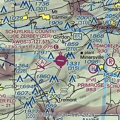
| Sectional chart |
|---|
|
| Airport distance calculator |
|---|
|
|
| Sunrise and sunset |
|---|
|
Times for 26-Dec-2025
| | Local
(UTC-5) | | Zulu
(UTC) |
|---|
| Morning civil twilight | | 06:58 | | 11:58 |
| Sunrise | | 07:29 | | 12:29 |
| Sunset | | 16:43 | | 21:43 |
| Evening civil twilight | | 17:14 | | 22:14 |
|
| Current date and time |
|---|
| Zulu (UTC) | 26-Dec-2025 11:53:43 |
|---|
| Local (UTC-5) | 26-Dec-2025 06:53:43 |
|---|
|
| METAR |
|---|
| KZER | 261135Z AUTO 03004KT 10SM SCT110 M07/M14 A3014 RMK AO2
|
KMUI
20nm SW | 261055Z AUTO 03004KT 10SM SCT100 BKN150 M03/M10 A3021 RMK AO2 SLP238 T10291105
|
|
| NOTAMs |
|---|
NOTAMs are issued by the DoD/FAA and will open in a separate window not controlled by AirNav.
|
|

