FAA INFORMATION EFFECTIVE 22 JANUARY 2026
Location
| FAA Identifier: | MUI |
| Lat/Long: | 40-26-06.8289N 076-34-07.0732W
40-26.113815N 076-34.117887W
40.4352302,-76.5686314
(estimated) |
| Elevation: | 487.1 ft. / 148.5 m (surveyed) |
| Variation: | 10W (1980) |
| From city: | 6 miles N of FORT INDIANTOWN GAP (ANNVILLE), PA |
| Time zone: | UTC -5 (UTC -4 during Daylight Saving Time) |
| Zip code: | 17038 |
Heliport Operations
| Heliport use: | Private use. Permission required prior to landing |
| Control tower: | yes |
| ARTCC: | NEW YORK CENTER |
| FSS: | WILLIAMSPORT FLIGHT SERVICE STATION |
| NOTAMs facility: | IPT (NOTAM-D service available) |
| Attendance: | 1 APR-31 OCT MON-FRI 1400-0500Z++, 1 NOV-31 MAR MON-FRI 1300-0300Z++
OPEN ADDN HR FOR SKED TRNG. SEE FLIP AP/1 SUPPLEMENTARY ARPT RMK. |
| Wind indicator: | yes |
| Segmented circle: | no |
| Lights: | ACTVT MIRL RWY 07/25 - ATCT |
| Beacon: | white-white-green (lighted military airport)
Operates sunset to sunrise. |
Heliport Communications
| CTAF: | 126.2 |
| WX ASOS: | 124.175 (717-861-6493) |
| MUIR GROUND: | 135.675 269.525 [TWR OPR 1300-0600Z++ MON-FRI MAY-AUG, 1300-0500Z++ MON-FRI SEP-APR, CLSD WKEND & HOL.] |
| MUIR TOWER: | 126.2 290.325 [TWR OPR 1300-0600Z++ MON-FRI MAY-AUG, 1300-0500Z++ MON-FRI SEP-APR, CLSD WKEND & HOL.] |
| HARRISBURG APPROACH: | 118.25 |
| HARRISBURG DEPARTURE: | 118.25 |
| ARNG OPS: | 40.075FM |
| EMERG: | 121.5 243.0 |
| FLT FLW: | 36.075FM |
| WX AWOS-2 at 9D4 (12 nm SE): | 118.45 (717-866-2906) |
| WX ASOS at MDT (17 nm SW): | PHONE 717-944-1372 |
| WX ASOS at CXY (18 nm SW): | PHONE 717-216-0264 |
| WX AWOS-3 at ZER (19 nm NE): | 127.575 (570-544-2778) |
Nearby radio navigation aids
| VOR radial/distance | | VOR name | | Freq | | Var |
|---|
| RAVr180/7.2 | | RAVINE VORTAC | | 114.60 | | 11W |
| LRPr335/22.8 | | LANCASTER VOR/DME | | 117.30 | | 09W |
| HARr081/24.2 | | HARRISBURG VORTAC | | 115.35 | | 10W |
| SEGr154/25.7 | | SELINSGROVE VOR/DME | | 110.40 | | 08W |
| MIPr182/35.6 | | MILTON VORTAC | | 109.20 | | 09W |
| NDB name | | Hdg/Dist | | Freq | | Var | | ID |
|---|
| BELLGROVE | | at field | | 328 | | 10W | | BZJ | -... --.. .--- |
Heliport Services
Runway Information
Runway 7/25
| Dimensions: | 3981 x 98 ft. / 1213 x 30 m
RWY 07 DTHR AREA CLSD TO ALL ACFT OPRNS. |
| Surface: | asphalt, in good condition |
| Weight bearing capacity: | |
| Runway edge lights: | medium intensity |
| RUNWAY 7 | | RUNWAY 25 |
| Latitude: | 40-25.948000N | | 40-26.279667N |
| Longitude: | 076-34.488000W | | 076-33.747833W |
| Elevation: | 460.1 ft. | | 480.0 ft. |
| Traffic pattern: | right | | left |
| Runway heading: | 070 magnetic, 060 true | | 250 magnetic, 240 true |
| Displaced threshold: | 350 ft. | | 121 ft. |
| Runway end identifier lights: | no | | no |
| Touchdown point: | yes, no lights | | yes, no lights |
| Instrument approach: | | | ILS/DME |
Helipad H3
| Dimensions: | 120 x 120 ft. / 37 x 37 m |
| Surface: | concrete |
| Latitude: | 40-26.039333N | | |
| Longitude: | 076-34.011500W | | |
| Elevation: | 465.7 ft. | | |
| Traffic pattern: | left | | left |
Helipad H1
| Dimensions: | 100 x 100 ft. / 30 x 30 m |
| Surface: | concrete |
| Latitude: | 40-26.238000N | | |
| Longitude: | 076-33.929667W | | |
| Elevation: | 485.2 ft. | | |
| Traffic pattern: | left | | left |
Helipad H2
| Dimensions: | 100 x 100 ft. / 30 x 30 m |
| Surface: | concrete |
| Latitude: | 40-26.143500N | | |
| Longitude: | 076-34.140667W | | |
| Elevation: | 489.6 ft. | | |
| Traffic pattern: | left | | left |
Helipad H4
| Dimensions: | 64 x 64 ft. / 20 x 20 m |
| Surface: | concrete |
| Latitude: | 40-26.113333N | | |
| Longitude: | 076-33.871667W | | |
| Elevation: | 472.2 ft. | | |
| Traffic pattern: | left | | left |
Heliport Ownership and Management from official FAA records
| Ownership: | U.S. Army |
| Owner: | US ARMY ATCA-ASO
CAMERON STA
ALEXANDRIA, VA 22314 |
| Manager: | AIRFIELD OPS
Phone 717-861-8963 |
Additional Remarks
| - | FUEL: J8 - PPR, 24 HR WKD, 48 HR WKEND, FOR FUEL AND PRK THRU ARNG OPS C717-861-8963, DSN 491-8963. |
| - | RSTD: PPR 24 HR WKD 48 HR WKEND. PPR ALL TRAN ACFT. CTC OPS DSN 491-8963, C717-861-8963. |
| - | CAUTION: RWY HAS GRADUAL 30' RISE FR APCH END RWY 07 TO A PT 2800' UP RWY, RWY ENDS NOT MUTUALLY VIS. LGTD WATER TWR .7 NM W AND 0.5 NM S OF AFLD. |
| - | TFC PAT: R/W 1200' MSL. |
| - | FSS: WILLIAMSPORT IPT-NOTAM IPT |
| - | MISC: LTD PRK. |
| - | MISC: WX 1200-0300Z++ EXCLD WKEND AND HOL, OT CTC 15 OWS, SCOTT AFB, DSN 576-9755. 2 HR LEAD TIME RQR. |
| - | LGTD WATER TWR .7 NM W. |
| - | RSTD: PPR 24 HR, CALL DUR NML DUTY HR. PPR ALL TRAN ACFT. CTC OPS DSN 491-8963, C717-861-8963. |
| - | AIRFIELD CLSD ON WKENDS AND HOL. ANY ACFT ARRIVING OR DEPARTING ON WKENDS OR HOL REQUIRES PRIOR APVL. ACCESS TO AIRFIELD IS RSTD WHEN CLSD. CTC MUIR AHP OPS AT (717) 861-8963; DSN 491-8963. |
| - | FOR CD WHEN ATCT CLSD, CTC HARRISBURG APCH AT 800-932-0712. |
| - | RSTD: AUGMENTED/MAN VIS OBS FM 20 FT AGL. BLDG OBSTN MAY IMPACT PREVAILING VIS 270-020. |
| - | MISC: WX STN DSN 491-2536, C717-861-2536, AN/FMQ-19 ASOS IN USE. AUGMENTED WHEN NEC DRG WX STN HRS. |
| - | ECHO 5 PARKING PAD IS FOR VIP LOADING AND UNLOADING ONLY. |
| - | MISC: CLASS D AIRSPACE REVERTS TO CLASS G SFC-700 FT, CLASS E 700 FT-3000 FT WHEN TWR CLSD. |
| - | MISC: INST PROCEDURES MAY INADVERTENTLY INTERRUPT LOCALIZED GND TRNG AT R5802. ALL TRAN ACFT OR CREWS UNFAMILIAR WITH MUIR AHP ARE HIGHLY ADVS TO PRACTICE INST PROCEDURES UNDER VFR IN VMC TO THE MAX EXTENT.PRACTICE INST PROCEDURES UNDER IFR ARE NOT RECOMMENDED. SEE AP 1 FOR MORE INFORMATION. |
| - | ROTARY WING TRAFFIC ONLY. |
Instrument Procedures
NOTE: All procedures below are presented as PDF files. If you need a reader for these files, you should download the free Adobe Reader.NOT FOR NAVIGATION. Please procure official charts for flight.
FAA instrument procedures published for use from 22 January 2026 at 0901Z to 19 February 2026 at 0900z.
IAPs - Instrument Approach Procedures |
|---|
| COPTER ILS OR LOC RWY 25 | |
download (125KB) |
| COPTER RNAV (GPS) 054 | |
download (72KB) |
| COPTER RNAV (GPS) RWY 25 | |
download (69KB) |
Departure Procedures |
|---|
| COPTER MUIR FOUR | |
download (103KB) |
| NOTE: Special Take-Off Minimums/Departure Procedures apply | |
download (432KB) |
Other nearby airports with instrument procedures:
74N - Bendigo Airport (7 nm N)
58N - Reigle Field Airport (9 nm S)
9D4 - Deck Airport (12 nm SE)
08N - Keller Brothers Airport (14 nm SE)
KMDT - Harrisburg International Airport (17 nm SW)
KCXY - Capital City Airport (18 nm SW)
KZER - Schuylkill County/Joe Zerbey Airport (19 nm NE)
|
|

Road maps at:
MapQuest
Bing
Google
| Aerial photo |
|---|
WARNING: Photo may not be current or correct
 Photo by David Newcomer
Photo taken 15-Aug-2015
looking west from 4,500 MSL.
Photo by David Newcomer
Photo taken 15-Aug-2015
looking west from 4,500 MSL.
Do you have a better or more recent aerial photo of Muir (Fort Indiantown Gap) Army Heliport that you would like to share? If so, please send us your photo.
|
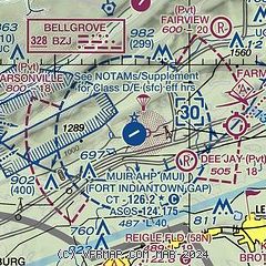
| Sectional chart |
|---|
|
| Airport distance calculator |
|---|
|
|
| Sunrise and sunset |
|---|
|
Times for 15-Feb-2026
| | Local
(UTC-5) | | Zulu
(UTC) |
|---|
| Morning civil twilight | | 06:33 | | 11:33 |
| Sunrise | | 07:01 | | 12:01 |
| Sunset | | 17:40 | | 22:40 |
| Evening civil twilight | | 18:08 | | 23:08 |
|
| Current date and time |
|---|
| Zulu (UTC) | 15-Feb-2026 16:44:35 |
|---|
| Local (UTC-5) | 15-Feb-2026 11:44:35 |
|---|
|
| METAR |
|---|
| KMUI | 151555Z AUTO 00000KT 10SM FEW080 OVC150 04/M01 A3002 RMK AO2 SLP174 T00371007
|
KMDT
17nm SW | 151556Z 00000KT 5SM HZ SCT080 OVC200 01/M02 A3004 RMK AO2 SLP176 T00111022
|
KCXY
18nm SW | 151556Z 00000KT 8SM CLR 02/M02 A3004 RMK AO2 SLP178 T00221022
|
KZER
19nm NE | 151635Z AUTO 16004KT 10SM BKN065 05/M02 A3000 RMK AO2
|
|
| TAF |
|---|
KMDT
17nm SW | 151536Z 1516/1612 08004KT 3SM BR OVC150 FM151800 11003KT P6SM BKN050 OVC100 FM152000 12004KT 3SM -RASN BR OVC050 FM160100 09007KT 2SM -RASN BR OVC015 FM161100 VRB05KT 5SM BR BKN020
|
|
| NOTAMs |
|---|
NOTAMs are issued by the DoD/FAA and will open in a separate window not controlled by AirNav.
|
|

