FAA INFORMATION EFFECTIVE 11 JUNE 2026
Location
| FAA Identifier: | GCN |
| Lat/Long: | 35-57-08.5000N 112-08-49.1000W
35-57.141667N 112-08.818333W
35.9523611,-112.1469722
(estimated) |
| Elevation: | 6608.9 ft. / 2014.4 m (surveyed) |
| Variation: | 11E (2020) |
| From city: | 6 miles S of GRAND CANYON, AZ |
| Time zone: | UTC -7 (year round; does not observe DST) |
| Zip code: | 86023 |
Airport Operations
| Airport use: | Open to the public |
| Activation date: | 05/1962 |
| Control tower: | yes |
| ARTCC: | LOS ANGELES CENTER |
| FSS: | PRESCOTT FLIGHT SERVICE STATION |
| NOTAMs facility: | GCN (NOTAM-D service available) |
| Attendance: | OCT 1 - MAY 31 0700-1900, JUN 1 - SEP 30 0600-2000 |
| Wind indicator: | lighted |
| Segmented circle: | yes |
| Lights: | WHEN ATCT CLSD ACTVT PAPI RWY 21; MIRL RWY 03/21 - CTAF. |
| Beacon: | white-green (lighted land airport)
Operates sunset to sunrise. |
| Landing fee: | no, OVNGT PRKG & COML LNDG FEE. |
| Fire and rescue: | ARFF index B |
Airport Communications
| CTAF: | 119.0 |
| UNICOM: | 122.95 |
| ATIS: | 124.3 |
| WX ASOS: | PHONE 928-638-0672 |
| CANYON GROUND: | 121.9 [JUN 1 - SEP 30 - 0600-2000, OCT 1 - MAY 31 0700-1900] |
| CANYON TOWER: | 119.0 [JUN 1 - SEP 30 - 0600-2000, OCT 1 - MAY 31 0700-1900] |
| EMERG: | 121.5 |
- APCH/DEP CTL SVC PRVDD BY LOS ANGELES ARTCC (ZLA) ON FREQS 124.85/319.2 (SELIGMAN RCAG).
- COMMUNICATIONS PRVDD BY PRESCOTT RADIO ON FREQ 122.4 (GRAND CANYON RCO) WHEN ATCT IS CLSD.
- COMMUNICATIONS PRVDD BY PRESCOTT RADIO ON FREQ 122.3 (COTTONWOOD RCO).
- SAID IN USE. OPERATE TRANSPONDERS WITH ALTITUDE REPORTING MODE AND ADS-B (IF EQUIPPED) ENABLED ON ALL AIRPORT SURFACES.
Nearby radio navigation aids
| VOR radial/distance | | VOR name | | Freq | | Var |
|---|
| GCN at field | | GRAND CANYON VOR/DME | | 111.65 | | 15E |
Airport Services
| Fuel available: | 100LL JET-A
100LL:AVBL H24 - 928-638-7117. |
| Parking: | tiedowns |
| Airframe service: | MINOR |
| Powerplant service: | MAJOR |
| Bottled oxygen: | LOW |
| Bulk oxygen: | LOW |
Runway Information
Runway 3/21
| Dimensions: | 8999 x 150 ft. / 2743 x 46 m |
| Surface: | asphalt/grooved, in fair condition |
| Weight bearing capacity: | | Single wheel: | 88.0 | | Double wheel: | 108.0 | | Double tandem: | 160.0 |
|
| Runway edge lights: | medium intensity |
| Operational restrictions: | LGTD DSTC RMNG SIGNS E SIDE. |
| RUNWAY 3 | | RUNWAY 21 |
| Latitude: | 35-56.578973N | | 35-57.703797N |
| Longitude: | 112-09.411697W | | 112-08.223612W |
| Elevation: | 6533.1 ft. | | 6608.8 ft. |
| Traffic pattern: | left | | right |
| Runway heading: | 030 magnetic, 041 true | | 210 magnetic, 221 true |
| Declared distances: | TORA:8999 TODA:8999 ASDA:8999 LDA:8999 | | TORA:8999 TODA:8999 ASDA:8999 LDA:8999 |
| Markings: | precision, in good condition | | nonprecision, in good condition |
| Visual slope indicator: | | | 4-light PAPI on right (4.00 degrees glide path) |
| Runway end identifier lights: | no | | yes |
| Touchdown point: | yes, no lights | | yes, no lights |
| Instrument approach: | LOC/GS | | |
Airport Ownership and Management from official FAA records
| Ownership: | Publicly-owned |
| Owner: | STATE OF ARIZONA
DEPARTMENT OF TRANS-ASD, 206 S. 17TH AVE MD178
PHOENIX, AZ 85007
Phone (602) 712-6255 |
| Manager: | DAVID REFFNER
PO BOX 3399
GRAND CANYON, AZ 86023
Phone 623-695-8656 |
Additional Remarks
| A39-03/21 | PCR VALUE: 380/F/C/X/T |
| - | CONDORS INVOF ARPT. |
| - | NMRS AIR TAX OPS INVOF GRAND CANYON; SEE SPL NOTICES GRAND CANYON SPL FLT RULES AREA. |
| - | ARFF INDEX B 24 HR PPR - AMGR. |
| - | FOR CD IF UNA TO CTC ON FSS FREQ, CTC LOS ANGELES ARTCC AT 661-575-2079. |
Instrument Procedures
NOTE: All procedures below are presented as PDF files. If you need a reader for these files, you should download the free Adobe Reader.NOT FOR NAVIGATION. Please procure official charts for flight.
FAA instrument procedures published for use from 11 June 2026 at 0901Z to 09 July 2026 at 0900z.
IAPs - Instrument Approach Procedures |
|---|
| ILS OR LOC RWY 03 | |
download (247KB) |
| RNAV (GPS) RWY 03 | |
download (206KB) |
| VOR RWY 03 | |
download (168KB) |
| NOTE: Special Alternate Minimums apply | |
download (118KB) |
Departure Procedures |
|---|
| PARKS FOUR | |
download (162KB) |
|
|---|
| GRAND FOUR (OBSTACLE) | |
download (382KB) |
| NOTE: Special Take-Off Minimums/Departure Procedures apply | |
download (348KB) |
Other nearby airports with instrument procedures:
40G - Valle Airport (18 nm S)
KCMR - H A Clark Memorial Field Airport (39 nm S)
KFLG - Flagstaff Pulliam Airport (54 nm SE)
KKNB - Kanab Municipal Airport (66 nm N)
KPGA - Page Municipal Airport (67 nm NE)
|
|

Road maps at:
MapQuest
Bing
Google
| Aerial photo |
|---|
WARNING: Photo may not be current or correct
 Photo by David Newcomer
Photo taken 20-Sep-2010
from 3,000' AGL looking southwest.
Photo by David Newcomer
Photo taken 20-Sep-2010
from 3,000' AGL looking southwest.
Do you have a better or more recent aerial photo of Grand Canyon National Park Airport that you would like to share? If so, please send us your photo.
|
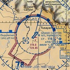
| Sectional chart |
|---|
|
 Download PDF
of official airport diagram from the FAA
| Airport distance calculator |
|---|
|
|
| Sunrise and sunset |
|---|
|
Times for 12-Jun-2026
| | Local
(UTC-7) | | Zulu
(UTC) |
|---|
| Morning civil twilight | | 04:42 | | 11:42 |
| Sunrise | | 05:12 | | 12:12 |
| Sunset | | 19:44 | | 02:44 |
| Evening civil twilight | | 20:15 | | 03:15 |
|
| Current date and time |
|---|
| Zulu (UTC) | 12-Jun-2026 15:29:28 |
|---|
| Local (UTC-7) | 12-Jun-2026 08:29:28 |
|---|
|
| METAR |
|---|
| KGCN | 121454Z 27008KT 10SM CLR 23/M01 A3024 RMK AO2 SLP121 T02331006 51010
|
|
| TAF |
|---|
| KGCN | 121120Z 1212/1312 VRB03KT P6SM SCT250 FM121700 25008G18KT P6SM FEW100 BKN200 FM130300 24006KT P6SM FEW150 BKN200 FM130600 VRB03KT P6SM FEW150 SCT250
|
|
| NOTAMs |
|---|
NOTAMs are issued by the DoD/FAA and will open in a separate window not controlled by AirNav.
|
|


