FAA INFORMATION EFFECTIVE 14 MAY 2026
Location
| FAA Identifier: | HZL |
| Lat/Long: | 40-59-12.3810N 075-59-40.9310W
40-59.206350N 075-59.682183W
40.9867725,-75.9947031
(estimated) |
| Elevation: | 1603.4 ft. / 488.7 m (surveyed) |
| Variation: | 10W (1980) |
| From city: | 2 miles NW of HAZLETON, PA |
| Time zone: | UTC -4 (UTC -5 during Standard Time) |
| Zip code: | 18201 |
Airport Operations
| Airport use: | Open to the public |
| Activation date: | 12/1949 |
| Control tower: | no |
| ARTCC: | NEW YORK CENTER |
| FSS: | WILLIAMSPORT FLIGHT SERVICE STATION |
| NOTAMs facility: | IPT (NOTAM-D service available) |
| Attendance: | MON - WED 0600-1600, ALL THUR - SUN 0730-1600 |
| Wind indicator: | lighted |
| Segmented circle: | yes |
| Lights: | ACTVT MALS RWY 28; REIL RWY 10; PAPI RWY 10; MIRL RWY 10/28 (3,5,7 CLICKS) - CTAF. |
| Beacon: | white-green (lighted land airport)
Operates sunset to sunrise. |
| Landing fee: | no, JET, TURBOPROP AND CORPORATE AIRCRAFT ONLY. |
Airport Communications
| CTAF/UNICOM: | 123.0 |
| WX AWOS-3: | 119.975 (570-459-4901) |
| WILKES-BARRE APPROACH: | 126.3 |
| WILKES-BARRE DEPARTURE: | 126.3 |
| CLEARANCE DELIVERY: | 121.7 ;CTC WILKES BARRE TWR |
| WX AWOS-3PT at 22N (15 nm SE): | 119.350 (570-386-3423) |
Nearby radio navigation aids
| VOR radial/distance | | VOR name | | Freq | | Var |
|---|
| LVZr229/22.0 | | WILKES-BARRE VORTAC | | 111.60 | | 10W |
| ETXr339/28.1 | | EAST TEXAS VOR/DME | | 110.20 | | 09W |
| FJCr312/29.1 | | ALLENTOWN VORTAC | | 117.50 | | 10W |
| MIPr103/30.4 | | MILTON VORTAC | | 109.20 | | 09W |
| RAVr058/37.8 | | RAVINE VORTAC | | 114.60 | | 11W |
Airport Services
| Fuel available: | 100LL JET-A
100LL:FUEL SVC AFT HRS BY PRIOR REQ 570-468-2479. |
| Parking: | hangars and tiedowns |
| Airframe service: | MINOR |
| Powerplant service: | MINOR |
| Bottled oxygen: | HIGH |
| Bulk oxygen: | NONE |
Runway Information
Runway 10/28
| Dimensions: | 5001 x 100 ft. / 1524 x 30 m |
| Surface: | asphalt/grooved, in good condition |
| Weight bearing capacity: | | Single wheel: | 47.0 | | Double wheel: | 74.0 |
|
| Runway edge lights: | medium intensity |
| RUNWAY 10 | | RUNWAY 28 |
| Latitude: | 40-59.235937N | | 40-59.176732N |
| Longitude: | 076-00.224167W | | 075-59.140215W |
| Elevation: | 1595.5 ft. | | 1594.5 ft. |
| Traffic pattern: | left | | right
VFR DEP PROCEDURE RIGHT TURN HEADING 300 DEGS AT END OF RY. |
| Runway heading: | 104 magnetic, 094 true | | 284 magnetic, 274 true |
| Displaced threshold: | 200 ft. | | 103 ft. |
| Declared distances: | TORA:5001 TODA:5001 ASDA:5001 LDA:4801 | | TORA:5001 TODA:5001 ASDA:5001 LDA:4898 |
| Markings: | nonprecision, in good condition | | nonprecision, in good condition |
| Visual slope indicator: | 4-light PAPI on left (3.50 degrees glide path) | | 4-light PAPI on left (3.17 degrees glide path) |
| Approach lights: | | | MALS: 1,400 foot medium intensity approach lighting system |
| Runway end identifier lights: | yes | | no |
| Touchdown point: | yes, no lights | | yes, no lights |
| Instrument approach: | | | LOC/DME |
| Obstructions: | 221 ft. trees, 5426 ft. from runway, 183 ft. left of centerline, 23:1 slope to clear
RWY 10 APCH SLP 25:1 TO DTHR. | | 45 ft. tree, 1111 ft. from runway, 97 ft. right of centerline, 20:1 slope to clear
RWY 28 APCH SLP 26:1 TO DTHR. |
Airport Ownership and Management from official FAA records
| Ownership: | Publicly-owned |
| Owner: | CITY OF HAZLETON
40 N CHURCH ST
HAZLETON, PA 18201
Phone (570) 436-6676 |
| Manager: | DAVE CHRONOWSKI
5175 OLD AIRPORT RD
HAZLE TWP, PA 18202
Phone (484) 661-8994 |
Additional Remarks
| - | AWOS AVBL 570-459-4901. |
| - | TYPE 1 AND 4 DEICING AVBL. |
Instrument Procedures
NOTE: All procedures below are presented as PDF files. If you need a reader for these files, you should download the free Adobe Reader.NOT FOR NAVIGATION. Please procure official charts for flight.
FAA instrument procedures published for use from 14 May 2026 at 0901Z to 11 June 2026 at 0900Z.
IAPs - Instrument Approach Procedures |
|---|
| RNAV (GPS) RWY 10 **CHANGED** | |
download (215KB) |
| RNAV (GPS) RWY 28 **CHANGED** | |
download (213KB) |
| LOC RWY 28 **CHANGED** | |
download (221KB) |
| NOTE: Special Alternate Minimums apply | |
download (42KB) |
| NOTE: Special Take-Off Minimums/Departure Procedures apply | |
download (311KB) |
Other nearby airports with instrument procedures:
22N - Jake Arner Memorial Airport (15 nm SE)
KWBW - Wilkes-Barre Wyoming Valley Airport (20 nm N)
N13 - Bloomsburg Municipal Airport (20 nm W)
KZER - Schuylkill County/Joe Zerbey Airport (24 nm SW)
KAVP - Wilkes-Barre/Scranton International Airport (24 nm NE)
|
|

Road maps at:
MapQuest
Bing
Google
| Aerial photo |
|---|
WARNING: Photo may not be current or correct
 Photo by Cathy Vajtay
Photo taken 07-Nov-2014
looking south from 4500'.
Photo by Cathy Vajtay
Photo taken 07-Nov-2014
looking south from 4500'.
Do you have a better or more recent aerial photo of Hazleton Regional Airport that you would like to share? If so, please send us your photo.
|
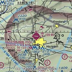
| Sectional chart |
|---|
|
| Airport distance calculator |
|---|
|
|
| Sunrise and sunset |
|---|
|
Times for 03-Jun-2026
| | Local
(UTC-4) | | Zulu
(UTC) |
|---|
| Morning civil twilight | | 05:01 | | 09:01 |
| Sunrise | | 05:34 | | 09:34 |
| Sunset | | 20:30 | | 00:30 |
| Evening civil twilight | | 21:03 | | 01:03 |
|
| Current date and time |
|---|
| Zulu (UTC) | 03-Jun-2026 14:27:14 |
|---|
| Local (UTC-4) | 03-Jun-2026 10:27:14 |
|---|
|
| METAR |
|---|
| KHZL | 031415Z AUTO 33004KT 10SM CLR 18/05 A3035 RMK AO2
|
K22N
15nm SE | 031415Z AUTO 33005KT 10SM CLR 23/05 A3028 RMK AO2
|
|
| NOTAMs |
|---|
NOTAMs are issued by the DoD/FAA and will open in a separate window not controlled by AirNav.
|
|


