FAA INFORMATION EFFECTIVE 04 SEPTEMBER 2025
Location
| FAA Identifier: | DDC |
| Lat/Long: | 37-45-47.2000N 099-57-55.5000W
37-45.786667N 099-57.925000W
37.7631111,-99.9654167
(estimated) |
| Elevation: | 2595.5 ft. / 791.1 m (surveyed) |
| Variation: | 08E (1990) |
| From city: | 3 miles E of DODGE CITY, KS |
| Time zone: | UTC -5 (UTC -6 during Standard Time) |
| Zip code: | 67801 |
Airport Operations
| Airport use: | Open to the public |
| Activation date: | 04/1940 |
| Control tower: | no |
| ARTCC: | KANSAS CITY CENTER |
| FSS: | WICHITA FLIGHT SERVICE STATION |
| NOTAMs facility: | DDC (NOTAM-D service available) |
| Attendance: | 0600-2200 |
| Wind indicator: | lighted |
| Segmented circle: | yes |
| Lights: | DUSK-DAWN. ACTVT MALSR RWY 14; REIL RWY 32; PAPI RWY 02 & 20, VASI RWY 14 & 32; MIRL RWY 14/32 & 02/20 - CTAF |
| Beacon: | white-green (lighted land airport)
Operates sunset to sunrise. |
| Fire and rescue: | ARFF index A |
| Airline operations: | ARFF INDEX B EQUIPMENT IS PROVIDED. 24 HRS PPR FOR UNSKED ACR OPNS WITH MORE THAN 30 PASSENGER SEATS; CALL FORD COUNTY COMMUNICATIONS AT 620-227-4646. |
Airport Communications
| CTAF/UNICOM: | 122.7 |
| WX ASOS: | 118.525 (620-501-5064) |
- APCH/DEP CTL SVC PRVDD BY KANSAS CITY ARTCC (ZKC) ON FREQS 125.2/285.425 (GARDEN CITY RCAG).
Nearby radio navigation aids
| VOR radial/distance | | VOR name | | Freq | | Var |
|---|
| DDCr152/5.6 | | DODGE CITY VORTAC | | 108.20 | | 08E |
| GCKr094/37.2 | | GARDEN CITY VORTAC | | 113.30 | | 11E |
Airport Services
| Fuel available: | 100LL JET-A |
| Parking: | hangars and tiedowns |
| Airframe service: | MAJOR |
| Powerplant service: | MAJOR |
| Bottled oxygen: | NONE |
| Bulk oxygen: | LOW |
Runway Information
Runway 14/32
| Dimensions: | 6899 x 100 ft. / 2103 x 30 m |
| Surface: | asphalt, in fair condition |
| Weight bearing capacity: | | PCN 32 /F/D/X/T | | Single wheel: | 81.0 | | Double wheel: | 103.0 | | Double tandem: | 168.0 |
|
| Runway edge lights: | medium intensity |
| RUNWAY 14 | | RUNWAY 32 |
| Latitude: | 37-46.389532N | | 37-45.369475N |
| Longitude: | 099-58.321135W | | 099-57.689617W |
| Elevation: | 2582.8 ft. | | 2586.5 ft. |
| Traffic pattern: | left | | left |
| Runway heading: | 146 magnetic, 154 true | | 326 magnetic, 334 true |
| Displaced threshold: | no | | 569 ft. |
| Declared distances: | TORA:6899 TODA:6899 ASDA:6329 LDA:6329 | | TORA:6899 TODA:6899 ASDA:6899 LDA:6329 |
| Markings: | precision, in good condition | | precision, in good condition |
| Visual slope indicator: | 4-box VASI on left (3.00 degrees glide path) | | 4-box VASI on left (3.00 degrees glide path) |
| Approach lights: | MALSR: 1,400 foot medium intensity approach lighting system with runway alignment indicator lights | | |
| Runway end identifier lights: | | | yes |
| Touchdown point: | yes, no lights | | yes, no lights |
| Instrument approach: | ILS | | |
Runway 2/20
| Dimensions: | 4649 x 100 ft. / 1417 x 30 m |
| Surface: | asphalt, in fair condition |
| Weight bearing capacity: | | PCN 9 /F/D/X/T | | Single wheel: | 24.0 |
|
| Runway edge lights: | medium intensity |
| Operational restrictions: | RWY 02/20 NOT AVBL FOR PART 121/PART 380 OPS WITH SKED PAX CARRYING OPS MORE THAN 9 PAX SEATS AND NON-SKED PAX CARRYING OPS MORE THAN 30 PAX SEATS. |
| RUNWAY 2 | | RUNWAY 20 |
| Latitude: | 37-45.326838N | | 37-45.973840N |
| Longitude: | 099-58.064977W | | 099-57.548770W |
| Elevation: | 2595.0 ft. | | 2563.8 ft. |
| Traffic pattern: | left | | left |
| Runway heading: | 024 magnetic, 032 true | | 204 magnetic, 212 true |
| Declared distances: | TORA:4649 TODA:4649 ASDA:4649 LDA:4649 | | TORA:4649 TODA:4649 ASDA:4649 LDA:4649 |
| Markings: | nonprecision, in fair condition | | nonprecision, in fair condition |
| Visual slope indicator: | 4-light PAPI on left (3.00 degrees glide path) | | 4-light PAPI on left (3.00 degrees glide path) |
| Runway end identifier lights: | no | | no |
| Touchdown point: | yes, no lights | | yes, no lights |
Airport Ownership and Management from official FAA records
| Ownership: | Publicly-owned |
| Owner: | CITY OF DODGE CITY
PO BOX 880
DODGE CITY, KS 67801
Phone 620-225-8100 |
| Manager: | MR ELIEL MARIN
100 AIRPORT RD
DODGE CITY, KS 67801
Phone 620-225-8280 |
Additional Remarks
| - | RWY ENDS 02 & 20 NOT VSB FM OPPOSITE ENDS. |
| - | FOR CD IF UNA TO CTC ON FSS FREQ, CTC KANSAS CITY ARTCC AT 913-254-8508. |
| - | TWY B BTN E SIDE RWY 14/32 & APCH END RWY 20, TWY B SOUTH END OF S APRON & APCH APCH END OF RWY 02 & TWY B1 UNUSBL BY ACR. |
Instrument Procedures
NOTE: All procedures below are presented as PDF files. If you need a reader for these files, you should download the free Adobe Reader.NOT FOR NAVIGATION. Please procure official charts for flight.
FAA instrument procedures published for use from 04 September 2025 at 0901Z to 02 October 2025 at 0900z.
IAPs - Instrument Approach Procedures |
|---|
| ILS OR LOC RWY 14 | |
download (271KB) |
| RNAV (GPS) RWY 02 | |
download (242KB) |
| RNAV (GPS) RWY 14 | |
download (243KB) |
| RNAV (GPS) RWY 20 | |
download (216KB) |
| RNAV (GPS) RWY 32 | |
download (275KB) |
| VOR RWY 14 | |
download (209KB) |
| VOR RWY 32 | |
download (205KB) |
| NOTE: Special Alternate Minimums apply | |
download (145KB) |
Other nearby airports with instrument procedures:
K79 - Jetmore Municipal Airport (14 nm N)
KMEJ - Meade Municipal Airport (35 nm SW)
KGCK - Garden City Regional Airport (37 nm W)
48K - Ness City Municipal Airport (43 nm N)
3K8 - Comanche County Airport (44 nm SE)
|
|

Road maps at:
MapQuest
Bing
Google
| Aerial photo |
|---|
WARNING: Photo may not be current or correct
 Photo by Von Rothenberger
Photo taken 13-Aug-2010
looking south.
Photo by Von Rothenberger
Photo taken 13-Aug-2010
looking south.
Do you have a better or more recent aerial photo of Dodge City Regional Airport that you would like to share? If so, please send us your photo.
|
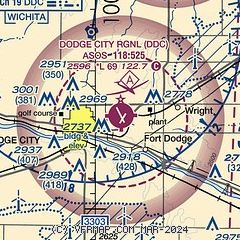
| Sectional chart |
|---|
|
 Download PDF
of official airport diagram from the FAA
| Airport distance calculator |
|---|
|
|
| Sunrise and sunset |
|---|
|
Times for 28-Sep-2025
| | Local
(UTC-5) | | Zulu
(UTC) |
|---|
| Morning civil twilight | | 07:08 | | 12:08 |
| Sunrise | | 07:34 | | 12:34 |
| Sunset | | 19:27 | | 00:27 |
| Evening civil twilight | | 19:53 | | 00:53 |
|
| Current date and time |
|---|
| Zulu (UTC) | 28-Sep-2025 20:40:58 |
|---|
| Local (UTC-5) | 28-Sep-2025 15:40:58 |
|---|
|
| METAR |
|---|
| KDDC | 281952Z AUTO 19014G23KT 7SM CLR 31/13 A3011 RMK AO2 SLP166 T03060128 $
|
|
| TAF |
|---|
| KDDC | 281724Z 2818/2918 19013KT P6SM FEW150 FM290000 16010KT P6SM SCT200
|
|
| NOTAMs |
|---|
NOTAMs are issued by the DoD/FAA and will open in a separate window not controlled by AirNav.
|
|


