FAA INFORMATION EFFECTIVE 30 OCTOBER 2025
Location
| FAA Identifier: | GCC |
| Lat/Long: | 44-20-56.0690N 105-32-21.7230W
44-20.934483N 105-32.362050W
44.3489081,-105.5393675
(estimated) |
| Elevation: | 4365.1 ft. / 1330.5 m (surveyed) |
| Variation: | 09E (2020) |
| From city: | 4 miles NW of GILLETTE, WY |
| Time zone: | UTC -7 (UTC -6 during Daylight Saving Time) |
| Zip code: | 82716 |
Airport Operations
| Airport use: | Open to the public |
| Activation date: | 11/1937 |
| Control tower: | no |
| ARTCC: | DENVER CENTER |
| FSS: | CASPER FLIGHT SERVICE STATION |
| NOTAMs facility: | GCC (NOTAM-D service available) |
| Attendance: | 0500-0000 |
| Pattern altitude: | 5165.1 ft. MSL
TPA: 800 FT AGL LGT ACFT, 1200 FT AGL LRG ACFT. |
| Wind indicator: | lighted |
| Segmented circle: | yes |
| Lights: | ACTVT MALSR RWY 34; REILS RWYS 03, 16, &21; HIRL RWY 16/34; MIRL RWY 03/21 - CTAF. SEQUENCE FLASHERS RWY 34 AVBL ON HIGH SETTING ONLY. PAPI RWYS 03, 16, 21, 34 OPR CONSLY. |
| Beacon: | white-green (lighted land airport)
Operates sunset to sunrise. |
| Fire and rescue: | ARFF index A |
| Airline operations: | PPR UNSKED ACR OPNS WITH MORE THAN 30 PSGR SEATS CALL AMGR 307-686-1042. |
Airport Communications
| CTAF: | 118.5 |
| UNICOM: | 122.95 |
| WX ASOS: | 124.175 (307-225-9101) |
- APCH/DEP CTL SVC PRVDD BY DENVER ARTCC (ZDV) ON FREQS 135.6/363.025 (SUNDANCE RCAG).
Nearby radio navigation aids
| VOR radial/distance | | VOR name | | Freq | | Var |
|---|
| GCC at field | | GILLETTE VOR/DME | | 114.60 | | 09E |
| NDB name | | Hdg/Dist | | Freq | | Var | | ID |
|---|
| DERYK | | 342/4.7 | | 380 | | 09E | | GC | --. -.-. |
Airport Services
| Fuel available: | 100LL JET-A JET-A+
100LL:FUEL AVBL H24 VIA CREDIT CARD. |
| Parking: | hangars and tiedowns |
| Airframe service: | NONE |
| Powerplant service: | NONE |
| Bottled oxygen: | NONE |
| Bulk oxygen: | HIGH/LOW |
Runway Information
Runway 16/34
| Dimensions: | 7501 x 150 ft. / 2286 x 46 m |
| Surface: | concrete/grooved, in good condition |
| Weight bearing capacity: | | Single wheel: | 70.0 | | Double wheel: | 110.0 | | Double tandem: | 160.0 |
|
| Runway edge lights: | high intensity |
| RUNWAY 16 | | RUNWAY 34 |
| Latitude: | 44-21.421570N | | 44-20.207390N |
| Longitude: | 105-32.634128W | | 105-32.325588W |
| Elevation: | 4337.0 ft. | | 4364.9 ft. |
| Traffic pattern: | left | | left |
| Runway heading: | 161 magnetic, 170 true | | 341 magnetic, 350 true |
| Declared distances: | TORA:7500 TODA:7500 ASDA:7500 LDA:7500 | | TORA:7500 TODA:7500 ASDA:7500 LDA:7500 |
| Markings: | precision, in good condition | | precision, in good condition |
| Visual slope indicator: | 4-light PAPI on left (3.17 degrees glide path) | | 4-light PAPI on left (3.20 degrees glide path) |
| Approach lights: | | | MALSR: 1,400 foot medium intensity approach lighting system with runway alignment indicator lights |
| Runway end identifier lights: | yes | | |
| Touchdown point: | yes, no lights | | yes, no lights |
| Instrument approach: | | | ILS/DME |
| Obstructions: | 56 ft. road, 1600 ft. from runway, 25:1 slope to clear
+56 FT BLDG 1600 FT FM RWY END 568 FT R. | | 312 ft. pline, 9732 ft. from runway, 1351 ft. right of centerline, 30:1 slope to clear |
Runway 3/21
| Dimensions: | 5804 x 75 ft. / 1769 x 23 m |
| Surface: | concrete/grooved, in good condition |
| Weight bearing capacity: | | Single wheel: | 40.0 | | Double wheel: | 60.0 |
|
| Runway edge lights: | medium intensity |
| RUNWAY 3 | | RUNWAY 21 |
| Latitude: | 44-20.715013N | | 44-21.464143N |
| Longitude: | 105-32.622470W | | 105-31.797105W |
| Elevation: | 4343.0 ft. | | 4317.0 ft. |
| Traffic pattern: | left | | left |
| Runway heading: | 029 magnetic, 038 true | | 209 magnetic, 218 true |
| Declared distances: | TORA:5803 TODA:5803 ASDA:5803 LDA:5803 | | TORA:5803 TODA:5803 ASDA:5803 LDA:5803 |
| Markings: | nonprecision, in good condition | | nonprecision, in good condition |
| Visual slope indicator: | 4-light PAPI on left (4.00 degrees glide path) | | 4-light PAPI on left (4.00 degrees glide path) |
| Runway end identifier lights: | yes | | yes |
| Touchdown point: | yes, no lights | | yes, no lights |
Airport Ownership and Management from official FAA records
| Ownership: | Publicly-owned |
| Owner: | CAMPBELL CO
307 TERMINAL LOOP, SUITE 108
GILLETTE, WY 82716
Phone 307-686-1042 |
| Manager: | TODD CHATFIELD
307 TERMINAL LOOP, SUITE 108
GILLETTE, WY 82716
Phone 307-686-1042
307-686-1042 |
Additional Remarks
| A39-16/34 | PCR VALUE: 580/R/D/W/T |
| A39-03/21 | PCR VALUE: 240/R/D/W/T |
| - | OPN ON UNPAVED SFCS PROHIBITED. |
| - | AFT HRS OPS CTC - 307-257-3137 |
| - | MINING/BLASTING OPNS 1/2 MILE N OF AOA DURG DALGT HRS. |
| - | BIRDS INVOF ARPT. |
| - | CONDS UNMON. |
Instrument Procedures
NOTE: All procedures below are presented as PDF files. If you need a reader for these files, you should download the free Adobe Reader.NOT FOR NAVIGATION. Please procure official charts for flight.
FAA instrument procedures published for use from 30 October 2025 at 0901Z to 27 November 2025 at 0900Z.
IAPs - Instrument Approach Procedures |
|---|
| ILS OR LOC RWY 34 | |
download (293KB) |
| RNAV (GPS) RWY 16 | |
download (213KB) |
| RNAV (GPS) RWY 34 | |
download (262KB) |
| VOR RWY 16 | |
download (232KB) |
| NOTE: Special Alternate Minimums apply | |
download (211KB) |
| NOTE: Special Take-Off Minimums/Departure Procedures apply | |
download (523KB) |
Other nearby airports with instrument procedures:
W43 - Hulett Municipal Airport (46 nm NE)
KBYG - Johnson County Airport (51 nm W)
KECS - Mondell Field Airport (60 nm SE)
KSHR - Sheridan County Airport (67 nm NW)
KEFC - Belle Fourche Municipal Airport (75 nm E)
|
|

Road maps at:
MapQuest
Bing
Google
| Aerial photo |
|---|
WARNING: Photo may not be current or correct
 Photo by David Newcomer
Photo taken 30-Sep-2011
looking north from 2,500' AGL.
Photo by David Newcomer
Photo taken 30-Sep-2011
looking north from 2,500' AGL.
Do you have a better or more recent aerial photo of Northeast Wyoming Regional Airport that you would like to share? If so, please send us your photo.
|
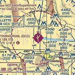
| Sectional chart |
|---|
|
| Airport distance calculator |
|---|
|
|
| Sunrise and sunset |
|---|
|
Times for 06-Nov-2025
| | Local
(UTC-7) | | Zulu
(UTC) |
|---|
| Morning civil twilight | | 06:17 | | 13:17 |
| Sunrise | | 06:47 | | 13:47 |
| Sunset | | 16:45 | | 23:45 |
| Evening civil twilight | | 17:15 | | 00:15 |
|
| Current date and time |
|---|
| Zulu (UTC) | 06-Nov-2025 17:23:35 |
|---|
| Local (UTC-7) | 06-Nov-2025 10:23:35 |
|---|
|
| METAR |
|---|
| KGCC | 061653Z AUTO VRB05KT 10SM OVC100 13/00 A2988 RMK AO2 SLP094 T01280000
|
|
| TAF |
|---|
| KGCC | 061120Z 0612/0712 30010KT P6SM VCSH OVC100 FM061500 30012G22KT P6SM SCT200 PROB30 0619/0622 -SHRA SCT050 BKN100 FM070000 28013KT P6SM SCT100
|
|
| NOTAMs |
|---|
NOTAMs are issued by the DoD/FAA and will open in a separate window not controlled by AirNav.
|
|


