FAA INFORMATION EFFECTIVE 27 NOVEMBER 2025
Location
| FAA Identifier: | ILE |
| Lat/Long: | 31-05-09.0000N 097-41-11.4000W
31-05.150000N 097-41.190000W
31.0858333,-97.6865000
(estimated) |
| Elevation: | 847.5 ft. / 258.3 m (surveyed) |
| Variation: | 05E (2010) |
| From city: | 3 miles E of KILLEEN, TX |
| Time zone: | UTC -6 (UTC -5 during Daylight Saving Time) |
| Zip code: | 76543 |
Airport Operations
| Airport use: | Open to the public |
| Activation date: | 08/1945 |
| Control tower: | no |
| ARTCC: | FORT WORTH CENTER |
| FSS: | SAN ANGELO FLIGHT SERVICE STATION |
| NOTAMs facility: | ILE (NOTAM-D service available) |
| Attendance: | 0800-1800 |
| Wind indicator: | lighted |
| Segmented circle: | yes |
| Lights: | SS-SR. MIRL RWY 01/19 PRESET LOW INTST; TO INCR INTST & ACTVT TWY LIGHTS - CTAF. |
| Beacon: | white-green (lighted land airport)
Operates sunset to sunrise. |
Airport Communications
| CTAF/UNICOM: | 122.7 |
| WX AWOS-3PT: | 128.575 (254-690-3131) |
| GRAY APPROACH: | 120.075 |
| GRAY DEPARTURE: | 120.075 |
| CLEARANCE DELIVERY: | 121.7 |
| WX AWOS-3PT at TPL (15 nm E): | 134.975 (254-774-8337) |
Nearby radio navigation aids
| VOR radial/distance | | VOR name | | Freq | | Var |
|---|
| GRKr057/7.3 | | GRAY VOR/DME | | 111.80 | | 07E |
| AGJr099/24.1 | | GOOCH SPRINGS VORTAC | | 112.50 | | 05E |
| NDB name | | Hdg/Dist | | Freq | | Var | | ID |
|---|
| IRESH | | 012/3.9 | | 278 | | 05E | | IL | .. .-.. |
Airport Services
| Fuel available: | 100LL JET-A |
| Parking: | tiedowns |
| Airframe service: | MINOR |
| Powerplant service: | MINOR |
| Bottled oxygen: | NONE |
| Bulk oxygen: | NONE |
Runway Information
Runway 1/19
| Dimensions: | 5495 x 100 ft. / 1675 x 30 m |
| Surface: | asphalt/aggregate friction seal coat, in good condition |
| Weight bearing capacity: | | Single wheel: | 17.0 | | Double wheel: | 50.0 |
|
| Runway edge lights: | medium intensity |
| RUNWAY 1 | | RUNWAY 19 |
| Latitude: | 31-04.715538N | | 31-05.583153N |
| Longitude: | 097-41.342555W | | 097-41.038155W |
| Elevation: | 847.3 ft. | | 840.4 ft. |
| Traffic pattern: | right | | left |
| Runway heading: | 012 magnetic, 017 true | | 192 magnetic, 197 true |
| Displaced threshold: | 854 ft. | | no |
| Declared distances: | TORA:5495 TODA:5495 ASDA:5495 LDA:4651 | | TORA:5495 TODA:5495 ASDA:5295 LDA:5295 |
| Markings: | precision, in good condition | | basic, in good condition |
| Visual slope indicator: | 4-light PAPI on left (3.00 degrees glide path) | | 4-light PAPI on left (3.00 degrees glide path) |
| Runway end identifier lights: | yes | | yes |
| Touchdown point: | yes, no lights | | yes, no lights |
| Instrument approach: | LOCALIZER | | |
| Obstructions: | 20 ft. road, 200 ft. from runway, 120 ft. right of centerline
APCH RATIO 0:1 AT DSPLCD THR TO BASED ON 14 FT GROUND 500 FT L. | | 24 ft. pline, 200 ft. from runway, 495 ft. right of centerline
4 FT GROUND 183 FT LEFT AT THR. |
Airport Ownership and Management from official FAA records
| Ownership: | Publicly-owned |
| Owner: | CITY OF KILLEEN
BOX 1329
KILLEEN, TX 76541
Phone 254-501-7600 |
| Manager: | MIKE WILSON
8101 CLEAR CREEK RD., BOX C
KILLEEN, TX 76549
Phone 254-501-8728 |
Additional Remarks
| - | FOR CD CTC FORT WORTH ARTCC AT 817-858-7584. |
| - | ARPT PHYSICAL ADDRESS 1523 STONETREE RD. KILLEEN, TX. |
Instrument Procedures
NOTE: All procedures below are presented as PDF files. If you need a reader for these files, you should download the free Adobe Reader.NOT FOR NAVIGATION. Please procure official charts for flight.
FAA instrument procedures published for use from 27 November 2025 at 0901Z to 25 December 2025 at 0900Z.
IAPs - Instrument Approach Procedures |
|---|
| RNAV (GPS) RWY 01 **CHANGED** | |
download (226KB) |
| LOC RWY 01 **CHANGED** | |
download (197KB) |
| VOR-A **CHANGED** | |
download (215KB) |
Departure Procedures |
|---|
| CONRA THREE | |
download (187KB) |
| LAMPS EIGHT | |
download (208KB) |
| NOTE: Special Take-Off Minimums/Departure Procedures apply | |
download (294KB) |
Other nearby airports with instrument procedures:
KHLR - Yoakum-Defrenn Army Heliport (3 nm NW)
KGRK - Robert Gray Army Airfield (7 nm W)
KTPL - Draughon-Miller Central Texas Regional Airport (15 nm E)
KGTU - Georgetown Executive Airport (24 nm S)
KLZZ - Lampasas Airport (26 nm W)
|
|

Road maps at:
MapQuest
Bing
Google
| Aerial photo |
|---|
WARNING: Photo may not be current or correct

Do you have a better or more recent aerial photo of Skylark Field Airport that you would like to share? If so, please send us your photo.
|
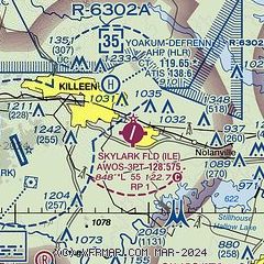
| Sectional chart |
|---|
|
| Airport distance calculator |
|---|
|
|
| Sunrise and sunset |
|---|
|
Times for 25-Dec-2025
| | Local
(UTC-6) | | Zulu
(UTC) |
|---|
| Morning civil twilight | | 07:01 | | 13:01 |
| Sunrise | | 07:28 | | 13:28 |
| Sunset | | 17:34 | | 23:34 |
| Evening civil twilight | | 18:00 | | 00:00 |
|
| Current date and time |
|---|
| Zulu (UTC) | 25-Dec-2025 08:12:33 |
|---|
| Local (UTC-6) | 25-Dec-2025 02:12:33 |
|---|
|
| METAR |
|---|
KILE
2nm SE | 250756Z AUTO 20008KT 10SM CLR A3019 RMK AO2 SLPNO FZRANO $
|
KHLR
3nm NW | 250755Z AUTO 20005KT 10SM CLR 18/16 A3017 RMK AO2 SLP209 T01800156
|
KGRK
8nm W | 250755Z AUTO 17008KT 10SM CLR 19/17 A3018 RMK AO2 SLP211 T01850165
|
KTPL
15nm E | 250751Z AUTO 17006KT CLR 16/14 A3019 RMK AO2 SLP217 T01560144 PWINO RVRNO $
|
|
| TAF |
|---|
KGRK
8nm W | 241600Z 2416/2522 21009KT 9999 BKN020 QNH3029INS TEMPO 2416/2418 SCT020 BECMG 2417/2418 20009KT 9999 FEW025 QNH3019INS BECMG 2508/2509 19009KT 9999 OVC015 QNH3018INS BECMG 2516/2517 18006KT 9999 FEW025 QNH3009INS TX28/2421Z TN16/2511Z
|
|
| NOTAMs |
|---|
NOTAMs are issued by the DoD/FAA and will open in a separate window not controlled by AirNav.
|
|


