FAA INFORMATION EFFECTIVE 19 MARCH 2026
Location
| FAA Identifier: | RBG |
| Lat/Long: | 43-14-21.6070N 123-21-21.0690W
43-14.360117N 123-21.351150W
43.2393353,-123.3558525
(estimated) |
| Elevation: | 533.4 ft. / 162.6 m (surveyed) |
| Variation: | 14E (2025) |
| From city: | 1 mile NW of ROSEBURG, OR |
| Time zone: | UTC -7 (UTC -8 during Standard Time) |
| Zip code: | 97470 |
Airport Operations
| Airport use: | Open to the public |
| Activation date: | 12/1938 |
| Control tower: | no |
| ARTCC: | SEATTLE CENTER |
| FSS: | MC MINNVILLE FLIGHT SERVICE STATION |
| NOTAMs facility: | RBG (NOTAM-D service available) |
| Attendance: | 0800-1700 |
| Wind indicator: | yes |
| Segmented circle: | yes |
| Lights: | ACTVT REIL RWY 16 & 34; MIRL RWY 16/34 - CTAF. RWY 34 PAPI OPR CONSLY. |
| Beacon: | white-green (lighted land airport)
Operates sunset to sunrise. |
Airport Communications
| CTAF/UNICOM: | 122.8 |
| WX ASOS: | 135.475 (541-673-1483) |
- APCH/DEP CTL SVC PRVDD BY SEATTLE ARTCC (ZSE) ON FREQS 127.55/239.0 (HORTON RCAG).
Nearby radio navigation aids
| VOR radial/distance | | VOR name | | Freq | | Var |
|---|
| RBGr337/3.4 | | ROSEBURG VOR/DME | | 114.45 | | 20E |
| OTHr092/37.0 | | NORTH BEND VOR/DME | | 113.85 | | 15E |
Airport Services
| Fuel available: | 100LL JET-A |
| Parking: | tiedowns |
| Airframe service: | MAJOR |
| Powerplant service: | MAJOR |
| Bottled oxygen: | NONE |
| Bulk oxygen: | HIGH |
Runway Information
Runway 16/34
| Dimensions: | 5003 x 100 ft. / 1525 x 30 m |
| Surface: | asphalt, in fair condition |
| Weight bearing capacity: | | Single wheel: | 42.0 | | Double wheel: | 54.0 | | Double tandem: | 88.0 |
|
| Runway edge lights: | medium intensity |
| RUNWAY 16 | | RUNWAY 34 |
| Latitude: | 43-14.771805N | | 43-13.948423N |
| Longitude: | 123-21.351787W | | 123-21.350525W |
| Elevation: | 533.4 ft. | | 500.8 ft. |
| Traffic pattern: | left | | left |
| Runway heading: | 166 magnetic, 180 true | | 346 magnetic, 360 true |
| Displaced threshold: | 1100 ft. | | 372 ft. |
| Markings: | nonprecision, in fair condition | | nonprecision, in fair condition |
| Visual slope indicator: | | | 4-light PAPI on right (4.00 degrees glide path) |
| Runway end identifier lights: | yes | | yes |
| Touchdown point: | yes, no lights | | yes, no lights |
| Obstructions: | 26 ft. hill, lighted, 380 ft. from runway, 250 ft. left of centerline, 6:1 slope to clear
14:1 BASED ON DSPLCD THR. | | 20 ft. road, 220 ft. from runway, 250 ft. left of centerline, 1:1 slope to clear
19:1 BASED ON DTHR. |
Airport Ownership and Management from official FAA records
| Ownership: | Publicly-owned |
| Owner: | CITY OF ROSEBURG
CITY HALL
ROSEBURG, OR 97470
Phone 541-672-7701 |
| Manager: | NIKKI MESSENGER
900 SE DOUGLAS
ROSEBURG, OR 97470
Phone 541-672-7701 |
Additional Remarks
| A30A-16 | 150 FT BLAST PAD MARKED WITH YELLOW CHEVRONS. |
| - | WATERFOWL ON & INVOF ARPT. |
| - | +700 TO 1200 FT TRRN SRND ARPT WI 2 MI. |
| - | FOR CD IF UNA TO CTC ON FSS FREQ, CTC SEATTLE ARTCC AT 253-351-3694. |
Instrument Procedures
NOTE: All procedures below are presented as PDF files. If you need a reader for these files, you should download the free Adobe Reader.NOT FOR NAVIGATION. Please procure official charts for flight.
FAA instrument procedures published for use from 19 March 2026 at 0901Z to 16 April 2026 at 0900Z.
IAPs - Instrument Approach Procedures |
|---|
| RNAV (GPS)-B | |
download (222KB) |
| VOR-A | |
download (211KB) |
| NOTE: Special Alternate Minimums apply | |
download (208KB) |
| NOTE: Special Take-Off Minimums/Departure Procedures apply | |
download (557KB) |
Other nearby airports with instrument procedures:
KOTH - Southwest Oregon Regional Airport (40 nm W)
3S8 - Grants Pass Airport (44 nm S)
77S - Hobby Field Airport (44 nm N)
KEUG - Mahlon Sweet Field Airport (53 nm N)
KMFR - Rogue Valley International/Medford Airport (56 nm S)
|
|

Road maps at:
MapQuest
Bing
Google
| Aerial photo |
|---|
WARNING: Photo may not be current or correct
 Photo by Al Gerharter
Photo taken 18-Dec-2009
Photo by Al Gerharter
Photo taken 18-Dec-2009
Do you have a better or more recent aerial photo of Roseburg Regional Airport that you would like to share? If so, please send us your photo.
|
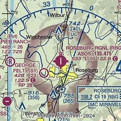
| Sectional chart |
|---|
|
| Airport distance calculator |
|---|
|
|
| Sunrise and sunset |
|---|
|
Times for 24-Mar-2026
| | Local
(UTC-7) | | Zulu
(UTC) |
|---|
| Morning civil twilight | | 06:42 | | 13:42 |
| Sunrise | | 07:10 | | 14:10 |
| Sunset | | 19:29 | | 02:29 |
| Evening civil twilight | | 19:58 | | 02:58 |
|
| Current date and time |
|---|
| Zulu (UTC) | 24-Mar-2026 09:38:46 |
|---|
| Local (UTC-7) | 24-Mar-2026 02:38:46 |
|---|
|
| METAR |
|---|
| KRBG | 240853Z AUTO 00000KT 10SM FEW050 SCT070 11/09 A3000 RMK AO2 SLP159 60000 T01060089 56012 $
|
|
| TAF |
|---|
| KRBG | 240530Z 2406/2506 VRB02KT P6SM VCSH OVC090 FM242200 19004KT P6SM -RA OVC060
|
|
| NOTAMs |
|---|
NOTAMs are issued by the DoD/FAA and will open in a separate window not controlled by AirNav.
|
|

