FAA INFORMATION EFFECTIVE 09 JULY 2026
Location
| FAA Identifier: | 04G |
| Lat/Long: | 41-07-49.7000N 080-37-10.5000W
41-07.828333N 080-37.175000W
41.1304722,-80.6195833
(estimated) |
| Elevation: | 1043.8 ft. / 318.2 m (surveyed) |
| Variation: | 08W (1995) |
| From city: | 2 miles NE of YOUNGSTOWN, OH |
| Time zone: | UTC -4 (UTC -5 during Standard Time) |
| Zip code: | 44505 |
Airport Operations
| Airport use: | Open to the public |
| Activation date: | 04/1946 |
| Control tower: | no |
| ARTCC: | CLEVELAND CENTER |
| FSS: | CLEVELAND FLIGHT SERVICE STATION |
| NOTAMs facility: | CLE (NOTAM-D service available) |
| Attendance: | IREG |
| Wind indicator: | yes |
| Segmented circle: | no |
Airport Communications
| CTAF/UNICOM: | 122.8 |
| YOUNGSTOWN APPROACH: | 133.95 |
| YOUNGSTOWN DEPARTURE: | 133.95 |
| WX ASOS at YNG (8 nm N): | PHONE 330-967-8953 |
| WX AWOS-3PT at UCP (11 nm SE): | 124.175 ((724) 652-4184) |
- APCH/DEP SVC PRVDD BY CLEVELAND ARTCC (ZOB) ON FREQS 120.775/298.95 (CHARDON RCAG) WHEN YOUNGSTOWN APCH CLSD.
Nearby radio navigation aids
| VOR radial/distance | | VOR name | | Freq | | Var |
|---|
| EWCr323/26.0 | | ELLWOOD CITY VOR/DME | | 115.80 | | 08W |
| ACOr091/26.3 | | AKRON VOR/DME | | 114.40 | | 04W |
| FKLr248/(39.0) | | FRANKLIN VOR | | 109.60 | | 06W |
| NDB name | | Hdg/Dist | | Freq | | Var | | ID |
|---|
| FETCH | | 202/4.3 | | 338 | | 08W | | YN | -.-- -. |
| CASTLE | | 314/11.2 | | 272 | | 09W | | UCP | ..- -.-. .--. |
Airport Services
Runway Information
Runway 2/20
| Dimensions: | 3073 x 50 ft. / 937 x 15 m |
| Surface: | asphalt, in poor condition
NMRS UNSEALED CRACKS.
SOUTH 305 FT CHEVRONED PAVEMENT HAS LRG DEPRESSIONS, DO NOT OPR IN THIS AREA. |
| Weight bearing capacity: | |
| Runway edge markings: | FADED.
NSTD BASIC DUE TO SML NRS & SML CNTRLN WITH NSTD SPACING. |
| RUNWAY 2 | | RUNWAY 20 |
| Latitude: | 41-07.584838N | | 41-08.072410N |
| Longitude: | 080-37.264395W | | 080-37.085257W |
| Elevation: | 1015.2 ft. | | 1043.5 ft. |
| Traffic pattern: | left | | left |
| Runway heading: | 024 magnetic, 016 true | | 204 magnetic, 196 true |
| Displaced threshold: | 305 ft. | | no |
| Markings: | NSTD, in poor condition | | NSTD, in poor condition |
| Runway end identifier lights: | no | | no |
| Touchdown point: | yes, no lights | | yes, no lights |
| Obstructions: | 40 ft. trees, 201 ft. from runway, 125 ft. left of centerline
+0-50 FT BRUSH/TREES, 0-200 FT DIST FM THR, 125 FT L/R; +0-50 FT BRUSH/TREES, 0-305 FT DIST FM DTHR, 25-125 FT L/R. | | 85 ft. trees, 275 ft. from runway, 100 ft. right of centerline
+0-65 FT BRUSH & TREES, 35-200 FT DIST, 125 FT L/R; +15 FT ROAD, 75 FT DIST, 125 FT L/R. |
Airport Ownership and Management from official FAA records
| Ownership: | Privately-owned |
| Owner: | LANSDOWNE AIRPORT ASSOCIATION
2350 LANSDOWNE BLVD
YOUNGSTOWN, OH 44505-3645
Phone 330-534-3580 |
| Manager: | ARTHUR TOBEY
205 CHARLES ST
HUBBARD, OH 44425-2108
Phone 330-534-3580
OR 330-233-0044. |
Additional Remarks
| A30A-02 | CALM WIND RWY. |
| - | APN IN POOR COND DUE TO BROKEN PAVEMENT, LOOSE STONES, & DEBRIS. |
| - | CTC AMGR BFR LDG FOR PAVEMENT COND. |
| - | DEER, BIRDS, & OTR WILDLIFE ON & INVOF ARPT. |
| - | FOR CD CTC YOUNGSTOWN APCH AT 330-856-4806, WHEN APCH CLSD CTC CLEVELAND ARTCC AT 440-774-0227/0490. |
Instrument Procedures
There are no published instrument procedures at 04G.
Some nearby airports with instrument procedures:
KYNG - Youngstown/Warren Regional Airport (8 nm N)
4G4 - Youngstown Elser Metro Airport (10 nm S)
KUCP - New Castle Municipal Airport (11 nm SE)
38D - Salem Airpark (15 nm SW)
29D - Grove City Airport (20 nm E)
|
|

Road maps at:
MapQuest
Bing
Google
| Aerial photo |
|---|
WARNING: Photo may not be current or correct
 Photo taken 30-Sep-2005
taken from the SW at 6000 ft MSL
Photo taken 30-Sep-2005
taken from the SW at 6000 ft MSL
Do you have a better or more recent aerial photo of Lansdowne Airport that you would like to share? If so, please send us your photo.
|
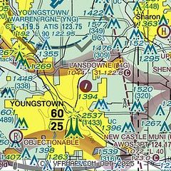
| Sectional chart |
|---|
|
| Airport distance calculator |
|---|
|
|
| Sunrise and sunset |
|---|
|
Times for 22-Jul-2026
| | Local
(UTC-4) | | Zulu
(UTC) |
|---|
| Morning civil twilight | | 05:38 | | 09:38 |
| Sunrise | | 06:10 | | 10:10 |
| Sunset | | 20:48 | | 00:48 |
| Evening civil twilight | | 21:20 | | 01:20 |
|
| Current date and time |
|---|
| Zulu (UTC) | 23-Jul-2026 01:04:16 |
|---|
| Local (UTC-4) | 22-Jul-2026 21:04:16 |
|---|
|
| METAR |
|---|
KYNG
7nm N | 230051Z VRB05KT 10SM FEW060 16/09 A3006 RMK AO2 SLP178 T01560094 $
|
KUCP
11nm SE | 230056Z AUTO 35003KT 10SM CLR 17/11 A3007 RMK AO2 SLP194 T01670106
|
|
| TAF |
|---|
KYNG
7nm N | 221732Z 2218/2318 30009KT P6SM BKN050 FM230000 VRB03KT P6SM SCT050 FM231400 35003KT P6SM FEW250
|
|
| NOTAMs |
|---|
NOTAMs are issued by the DoD/FAA and will open in a separate window not controlled by AirNav.
|
|


