FAA INFORMATION EFFECTIVE 17 APRIL 2025
Location
| FAA Identifier: | 17J |
| Lat/Long: | 31-00-23.4260N 084-52-39.4920W
31-00.390433N 084-52.658200W
31.0065072,-84.8776367
(estimated) |
| Elevation: | 147.4 ft. / 44.9 m (surveyed) |
| Variation: | 05W (2025) |
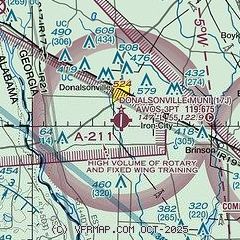
| From city: | 1 mile S of DONALSONVILLE, GA |
| Time zone: | UTC -4 (UTC -5 during Standard Time) |
| Zip code: | 31745 |
Airport Operations
| Airport use: | Open to the public |
| Activation date: | 07/1944 |
| Control tower: | no |
| ARTCC: | JACKSONVILLE CENTER |
| FSS: | MACON FLIGHT SERVICE STATION |
| NOTAMs facility: | MCN (NOTAM-D service available) |
| Attendance: | 0800-1700 |
| Wind indicator: | lighted |
| Segmented circle: | yes |
| Lights: | ACTVT MIRL RWY 01/19 - CTAF. PAPI RWY 01/19 OPR CONSLY DUSK - 2300, AFT 2300 - CTAF. |
| Beacon: | white-green (lighted land airport)
Operates sunset to sunrise. |
Airport Communications
| CTAF: | 122.9 |
| WX AWOS-3PT: | 119.675 (229-524-0001) |
| CAIRNS APPROACH: | 125.4 |
| CAIRNS DEPARTURE: | 125.4 |
| WX AWOS-3PT at BGE (13 nm E): | 121.125 (229-248-2104) |
| WX ASOS at MAI (19 nm SW): | 133.525 (850-482-6082) |
- APCH/DEP SVC PRVDD BY JACKSONVILLE ARTCC ON FREQS 134.3/322.55 (DOTHAN RCAG) WHEN CAIRNS APCH/DEP CLSD.
Nearby radio navigation aids
| VOR radial/distance | | VOR name | | Freq | | Var |
|---|
| MAIr044/18.3 | | MARIANNA VORTAC | | 114.00 | | 00E |
| RRSr118/33.0 | | WIREGRASS VORTAC | | 111.60 | | 02E |
| SZWr314/37.5 | | SEMINOLE VORTAC | | 117.50 | | 02E |
| NDB name | | Hdg/Dist | | Freq | | Var | | ID |
|---|
| WILLIS | | 280/18.3 | | 359 | | 04W | | LYZ | .-.. -.-- --.. |
| CAIDY | | 285/37.6 | | 338 | | 04W | | CYR | -.-. -.-- .-. |
Airport Services
| Fuel available: | 100LL
100LL:FUEL 24 HR CREDIT CARD SVC AVBL. |
| Parking: | hangars and tiedowns |
| Airframe service: | NONE |
| Powerplant service: | NONE |
| Bottled oxygen: | NONE |
| Bulk oxygen: | NONE |
Runway Information
Runway 1/19
| Dimensions: | 5512 x 100 ft. / 1680 x 30 m |
| Surface: | asphalt, in good condition |
| Weight bearing capacity: | |
| Runway edge lights: | medium intensity |
| RUNWAY 1 | | RUNWAY 19 |
| Latitude: | 30-59.936272N | | 31-00.844583N |
| Longitude: | 084-52.680925W | | 084-52.635465W |
| Elevation: | 129.9 ft. | | 146.9 ft. |
| Traffic pattern: | left | | left |
| Runway heading: | 007 magnetic, 002 true | | 187 magnetic, 182 true |
| Markings: | nonprecision, in good condition | | nonprecision, in good condition |
| Visual slope indicator: | 2-light PAPI on left (3.00 degrees glide path) | | 2-light PAPI on left (3.00 degrees glide path) |
| Touchdown point: | yes, no lights | | yes, no lights |
| Obstructions: | 80 ft. trees, 1160 ft. from runway, 641 ft. left of centerline, 12:1 slope to clear | | 64 ft. trees, 584 ft. from runway, 498 ft. left of centerline, 6:1 slope to clear |
Airport Ownership and Management from official FAA records
| Ownership: | Publicly-owned |
| Owner: | DONALSONVILLE - SEMINOLE COUNTY
PO BOX 671
DONALSVILLE, GA 39845
Phone 229-524-2118
AIRPORT COMMISSION |
| Manager: | JERRY ISLER
6063 SCOTT DRIVE
DONALSONVILLE, GA 39845
Phone 229-524-2118 |
Additional Remarks
| - | FOR CD CTC CAIRNS APCH AT 334-255-8402, WHEN APCH CLSD CTC JACKSONVILLE ARTCC AT 904-845-1592. |
Instrument Procedures
NOTE: All procedures below are presented as PDF files. If you need a reader for these files, you should download the free Adobe Reader.NOT FOR NAVIGATION. Please procure official charts for flight.
FAA instrument procedures published for use from 17 April 2025 at 0901Z to 15 May 2025 at 0900z.
IAPs - Instrument Approach Procedures |
|---|
| RNAV (GPS) RWY 01 | |
download (223KB) |
| RNAV (GPS) RWY 19 | |
download (196KB) |
| NOTE: Special Alternate Minimums apply | |
download (158KB) |
| NOTE: Special Take-Off Minimums/Departure Procedures apply | |
download (488KB) |
Other nearby airports with instrument procedures:
KBGE - Decatur County Industrial Air Park (13 nm E)
KMAI - Marianna Municipal Airport (19 nm SW)
KBIJ - Early County Airport (23 nm N)
2J9 - Quincy Municipal Airport (30 nm SE)
KHDL - Headland Municipal Airport (31 nm NW)
|
|

Road maps at:
MapQuest
Bing
Google
| Aerial photo |
|---|
WARNING: Photo may not be current or correct
 Photo taken 30-Apr-2007
Do you have a better or more recent aerial photo of Donalsonville Municipal Airport that you would like to share? If so, please send us your photo.
|
| Sectional chart |
|---|
|
| Airport distance calculator |
|---|
|
|
| Sunrise and sunset |
|---|
|
Times for 08-May-2025
| | Local
(UTC-4) | | Zulu
(UTC) |
|---|
| Morning civil twilight | | 06:24 | | 10:24 |
| Sunrise | | 06:50 | | 10:50 |
| Sunset | | 20:22 | | 00:22 |
| Evening civil twilight | | 20:48 | | 00:48 |
|
| Current date and time |
|---|
| Zulu (UTC) | 08-May-2025 20:09:10 |
|---|
| Local (UTC-4) | 08-May-2025 16:09:10 |
|---|
|
| METAR |
|---|
| K17J | 081955Z AUTO 23007G19KT 10SM BKN048 BKN060 32/17 A2995 RMK AO2 LTG DSNT SW
|
KBGE
13nm E | 081955Z AUTO 20006KT 10SM SCT060 SCT065 SCT110 32/20 A2993 RMK AO2 T03150195
|
KMAI
19nm SW | 081953Z AUTO 20012G17KT 10SM SCT050 SCT090 32/19 A2993 RMK AO2 LTG DSNT S AND SW SLP132 T03170189
|
|
| TAF |
|---|
KDHN
35nm NW | 081720Z 0818/0918 20005KT P6SM BKN050 FM081900 24005KT P6SM VCTS SCT035CB BKN080 FM090000 20007KT P6SM BKN100 FM090900 25004KT P6SM BKN015 FM091400 25006KT P6SM BKN050
|
|
| NOTAMs |
|---|
NOTAMs are issued by the DoD/FAA and will open in a separate window not controlled by AirNav.
|
|


