FAA INFORMATION EFFECTIVE 11 JUNE 2026
Location
| FAA Identifier: | 1F2 |
| Lat/Long: | 43-13-31.9870N 074-06-52.0207W
43-13.533117N 074-06.867012W
43.2255519,-74.1144502
(estimated) |
| Elevation: | 1070 ft. / 326.1 m (surveyed) |
| Variation: | 14W (1985) |
| From city: | 1 mile NW of EDINBURG, NY |
| Time zone: | UTC -4 (UTC -5 during Standard Time) |
| Zip code: | 12134 |
Airport Operations
| Airport use: | Open to the public |
| Control tower: | no |
| ARTCC: | BOSTON CENTER |
| FSS: | BURLINGTON FLIGHT SERVICE STATION |
| NOTAMs facility: | BTV (NOTAM-D service available) |
| Attendance: | UNATNDD |
| Wind indicator: | yes |
| Segmented circle: | yes |
Airport Communications
| CTAF/UNICOM: | 122.8 |
| WX AWOS-3 at 5B2 (15 nm SE): | 132.025 (518-884-9289) |
| WX AWOS-3 at NY0 (17 nm SW): | 119.225 (518-762-0322) |
Nearby radio navigation aids
| VOR radial/distance | | VOR name | | Freq | | Var |
|---|
| ALBr348/31.8 | | ALBANY VORTAC | | 115.30 | | 13W |
| CAMr306/36.5 | | CAMBRIDGE VOR/DME | | 115.00 | | 14W |
| NDB name | | Hdg/Dist | | Freq | | Var | | ID |
|---|
| JOHNSTOWN | | 049/16.6 | | 523 | | 14W | | JJH | .--- .--- .... |
| HUNTER | | 354/23.7 | | 356 | | 14W | | HEU | .... . ..- |
Airport Services
| Parking: | tiedowns |
| Airframe service: | NONE |
| Powerplant service: | NONE |
Runway Information
Runway 6/24
| Dimensions: | 2400 x 100 ft. / 732 x 30 m
RWY WIDTH EDGE MARKED WITH RED CONES ALL SEASONS EXCEPT WINTER |
| Surface: | turf, in good condition |
| RUNWAY 6 | | RUNWAY 24 |
| Latitude: | 43-13.396667N | | 43-13.666667N |
| Longitude: | 074-07.041667W | | 074-06.648333W |
| Elevation: | 1047.0 ft. | | 1060.0 ft. |
| Traffic pattern: | left | | left |
| Runway heading: | 061 magnetic, 047 true | | 241 magnetic, 227 true |
| Obstructions: | 63 ft. road, 38 ft. from runway, 100 ft. right of centerline
CTLNG OBSTN EXCEEDS 45 DEG SLP. | | 48 ft. road, 98 ft. from runway, 61 ft. right of centerline, 2:1 slope to clear
ROAD ON BOTH SIDES OF CTRLN RY 24. |
Runway 1/19
| Dimensions: | 2000 x 100 ft. / 610 x 30 m
RWY WIDTH EDGE MARKED WITH RED CONES ALL SEASONS EXCEPT WINTER |
| Surface: | turf, in good condition |
| RUNWAY 1 | | RUNWAY 19 |
| Latitude: | 43-13.370213N | | 43-13.699498N |
| Longitude: | 074-06.896147W | | 074-06.890705W |
| Elevation: | 1048.0 ft. | | 1067.0 ft. |
| Traffic pattern: | left | | left |
| Runway heading: | 015 magnetic, 001 true | | 195 magnetic, 181 true |
| Obstructions: | 54 ft. trees, 89 ft. from runway, 69 ft. right of centerline, 1:1 slope to clear
ROAD ON BOTH SIDES OF CTRLN RY 01. | | 35 ft. trees, 121 ft. from runway, 44 ft. right of centerline, 3:1 slope to clear
ROAD ON BOTH SIDES OF CTRLN AT AN ANGLE TO RY 19. |
Airport Ownership and Management from official FAA records
| Ownership: | Privately-owned |
| Owner: | ELAYNE WADE
23 WHEELER RD
EDINBURG, NY 12134
Phone 518-775-7431 |
| Manager: | MR BILL DEE WADE
23 WHEELER RD
EDINBURG, NY 12134
Phone 518-863-2725 |
Additional Remarks
| - | ULTRALGT ACFT ON & INVOF ARPT. |
| - | 4 FT GRAVEL PILE AT END OF RWY 01. |
| - | ACFT PARKED/HANGARED ON NON ARPT LAND. CROSS PUBLIC ROAD TO/FM ARPT. |
| - | RWY 24; +35 - 50 FT TREES, 90 - 250 FT FROM THLD, 0 - 125 FT R OF CNTRLN AND +50 FT TREES, 350 - 425 FT FROM THLD 110 - 150 FT L OF CNTRLN. |
| - | RWY 19; +17 - 52 FT TREES, 0 - 230 FT FROM THLD, 50 - 100 FT R OF CNTRLN. |
| - | RWY 1; +30 - 60 FT TREES, 0 - 240 FROM THLD, 15 - 100 FT L AND R OF CNTRLN. |
| - | RWY 6; +20 - 65 FT TREES, 0 - 500 FT FROM THLD, 30 - 150 L AND R OF CNTRLN. |
| - | FOR CD CTC ALBANY APCH AT 518-862-2299. |
| - | ARPT NOT PLOWED OR MNTND DURG WINTER MONTHS; RWY SFC CAN BE SOFT AS FROST LEAVES THE GND IN SPRING. |
Instrument Procedures
There are no published instrument procedures at 1F2.
Some nearby airports with instrument procedures:
5B2 - Saratoga County Airport (15 nm SE)
NY0 - Fulton County Airport (17 nm SW)
K09 - Piseco Airport (22 nm NW)
KGFL - Floyd Bennett Memorial Airport (23 nm E)
KSCH - Schenectady County Airport (24 nm S)
|
|

Road maps at:
MapQuest
Bing
Google
| Aerial photo |
|---|
WARNING: Photo may not be current or correct
 Photo taken 08-Jul-2006
Do you have a better or more recent aerial photo of Plateau Sky Ranch Airport that you would like to share? If so, please send us your photo.
|
| Sectional chart |
|---|
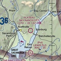
|
| Airport distance calculator |
|---|
|
|
| Sunrise and sunset |
|---|
|
Times for 21-Jun-2026
| | Local
(UTC-4) | | Zulu
(UTC) |
|---|
| Morning civil twilight | | 04:42 | | 08:42 |
| Sunrise | | 05:17 | | 09:17 |
| Sunset | | 20:39 | | 00:39 |
| Evening civil twilight | | 21:14 | | 01:14 |
|
| Current date and time |
|---|
| Zulu (UTC) | 21-Jun-2026 17:01:35 |
|---|
| Local (UTC-4) | 21-Jun-2026 13:01:35 |
|---|
|
| METAR |
|---|
KNY0
17nm SW | 211655Z AUTO 28008KT 10SM SCT047 SCT050 SCT085 22/12 A2988 RMK AO2 T02200124
|
KGFL
23nm E | 211553Z AUTO 00000KT 10SM SCT044 SCT050 BKN075 22/13 A2984 RMK AO2 SLP105 T02220128
|
KSCH
24nm S | 211454Z 27012G16KT 10SM CLR 22/12 A2987
|
KALB
32nm SE | 211651Z 27011G17KT 10SM SCT050 SCT090 24/12 A2986 RMK AO2 SLP109 T02440117 $
|
|
| TAF |
|---|
KGFL
23nm E | 211122Z 2112/2212 24005KT P6SM SCT100 BKN200 FM211600 28009G17KT P6SM VCSH BKN050 PROB30 2119/2123 5SM -SHRA BR BKN040 FM220000 VRB03KT P6SM FEW050 SCT200 FM220900 00000KT P6SM BKN200
|
|
| NOTAMs |
|---|
NOTAMs are issued by the DoD/FAA and will open in a separate window not controlled by AirNav.
|
|

