FAA INFORMATION EFFECTIVE 10 JULY 2025
Location
| FAA Identifier: | 1F7 |
| Lat/Long: | 32-48-46.6000N 096-21-07.3000W
32-48.776667N 096-21.121667W
32.8129444,-96.3520278
(estimated) |
| Elevation: | 510 ft. / 155 m (estimated) |
| Variation: | 06E (1985) |
| From city: | 23 miles E of DALLAS, TX |
| Time zone: | UTC -5 (UTC -6 during Standard Time) |
| Zip code: | 75032 |
Airport Operations
| Airport use: | Open to the public |
| Activation date: | 12/1979 |
| Control tower: | no |
| ARTCC: | FORT WORTH CENTER |
| FSS: | FORT WORTH FLIGHT SERVICE STATION |
| NOTAMs facility: | FTW (NOTAM-D service available) |
| Attendance: | UNATNDD |
| Wind indicator: | lighted |
| Segmented circle: | no |
| Lights: | SS-SR |
| Beacon: | white-green (lighted land airport)
Operates sunset to sunrise. |
Airport Communications
| CTAF/UNICOM: | 122.7 |
| WX ASOS at TRL (8 nm SE): | 119.275 (972-551-1334) |
| WX AWOS-3PT at F46 (8 nm NW): | 121.25 (469-991-7392) |
| WX AWOS-3 at HQZ (10 nm SW): | 118.175 (972-222-7631) |
Nearby radio navigation aids
| VOR radial/distance | | VOR name | | Freq | | Var |
|---|
| CVEr093/28.2 | | COWBOY VOR/DME | | 116.20 | | 06E |
| TTTr090/34.9 | | MAVERICK VOR/DME | | 113.10 | | 06E |
| CQYr344/38.2 | | CEDAR CREEK VORTAC | | 114.80 | | 06E |
Airport Services
| Fuel available: | 100LL |
| Airframe service: | MAJOR |
| Powerplant service: | MAJOR |
Runway Information
Runway 13/31
| Dimensions: | 2630 x 30 ft. / 802 x 9 m |
| Surface: | asphalt, in poor condition |
| Runway edge lights: | non-standard
NSTD FIXTURES |
| Runway edge markings: | NSTD RWY CL 8 IN WIDE. |
| RUNWAY 13 | | RUNWAY 31 |
| Latitude: | 32-48.931042N | | 32-48.620963N |
| Longitude: | 096-21.301587W | | 096-20.942318W |
| Traffic pattern: | right | | left |
| Runway heading: | 130 magnetic, 136 true | | 310 magnetic, 316 true |
| Markings: | NSTD, in fair condition | | NSTD, in fair condition |
| Obstructions: | 35 ft. tree, 201 ft. from runway, 78 ft. right of centerline
30 FT TREES 0-199 FT DSTC, 70 FT RIGHT. | | 35 ft. trees, 201 ft. from runway, 78 ft. left of centerline
30 FT TREES 0-199 FT DSTC, 78 FT LEFT. |
Airport Ownership and Management from official FAA records
| Ownership: | Privately-owned |
| Owner: | HECTOR & LUZ GAMEZ
11560 S STATE HWY 205
TERRELL, TX 75160
Phone 214-679-8277
ALT 214-914-5153 |
| Manager: | HECTOR & LUZ GAMEZ
11560 S STATE HWY 205
TERRELL, TX 75160
Phone 214-679-8277 |
Additional Remarks
| - | 4 FT FENCE PARL TO RWY, FULL LEN, 78 FT WEST OF RWY CNTRLN. |
| - | RWY 13/31, 15 FT DROP OFF EACH END. |
| - | RWY AND TWY SHOULDERS BROKEN, LOOSE AGGREGATE & STONES, EXTSV CRACKING AND SPALLING. TWY PVMT ROUGH & UNEVEN. |
| - | RWY 13 APCH EXPECT WIND SHEAR & TURB. |
| - | FOR CD CTC REGIONAL APCH AT 972-615-2799. |
Instrument Procedures
There are no published instrument procedures at 1F7.
Some nearby airports with instrument procedures:
KTRL - Terrell Municipal Airport (8 nm SE)
F46 - Ralph M Hall/Rockwall Municipal Airport (8 nm NW)
KHQZ - Mesquite Metro Airport (10 nm SW)
7F3 - Caddo Mills Municipal Airport (14 nm N)
KGVT - Majors Airport (21 nm NE)
|
|

Road maps at:
MapQuest
Bing
Google
| Aerial photo |
|---|
WARNING: Photo may not be current or correct

Do you have a better or more recent aerial photo of Airpark East Airport that you would like to share? If so, please send us your photo.
|
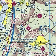
| Sectional chart |
|---|
|
| Airport distance calculator |
|---|
|
|
| Sunrise and sunset |
|---|
|
Times for 16-Jul-2025
| | Local
(UTC-5) | | Zulu
(UTC) |
|---|
| Morning civil twilight | | 06:02 | | 11:02 |
| Sunrise | | 06:30 | | 11:30 |
| Sunset | | 20:33 | | 01:33 |
| Evening civil twilight | | 21:01 | | 02:01 |
|
| Current date and time |
|---|
| Zulu (UTC) | 16-Jul-2025 11:01:07 |
|---|
| Local (UTC-5) | 16-Jul-2025 06:01:07 |
|---|
|
| METAR |
|---|
KTRL
7nm SE | 161053Z AUTO 16004KT 10SM CLR 24/22 A2998 RMK AO2 SLP144 T02390222
|
KF46
8nm NW | 161055Z AUTO 16005KT 10SM CLR 24/24 A2998 RMK AO2 T02410241
|
KHQZ
10nm SW | 161055Z AUTO 15004KT 7SM CLR 23/22 A2997 RMK AO1 T02320217
|
|
| TAF |
|---|
KDAL
25nm W | 160839Z 1609/1706 18011KT P6SM FEW240 TEMPO 1614/1617 BKN020
|
|
| NOTAMs |
|---|
NOTAMs are issued by the DoD/FAA and will open in a separate window not controlled by AirNav.
|
|


