FAA INFORMATION EFFECTIVE 14 MAY 2026
Location
| FAA Identifier: | 2B3 |
| Lat/Long: | 43-23-13.6870N 072-11-15.4110W
43-23.228117N 072-11.256850W
43.3871353,-72.1876142
(estimated) |
| Elevation: | 783.9 ft. / 238.9 m (surveyed) |
| Variation: | 16W (1985) |
| From city: | 2 miles N of NEWPORT, NH |
| Time zone: | UTC -4 (UTC -5 during Standard Time) |
| Zip code: | 03773 |
Airport Operations
| Airport use: | Open to the public |
| Activation date: | 02/1947 |
| Control tower: | no |
| ARTCC: | BOSTON CENTER |
| FSS: | BANGOR FLIGHT SERVICE STATION |
| NOTAMs facility: | BGR (NOTAM-D service available) |
| Attendance: | IREG |
| Wind indicator: | lighted |
| Segmented circle: | yes |
| Lights: | SS-SR |
| Beacon: | white-green (lighted land airport)
ROTG BCN OTS INDEFLY. Operates sunset to sunrise. |
Airport Communications
| CTAF/UNICOM: | 122.8 |
| WX ASOS at VSF (15 nm W): | 121.425 (802-886-6006) |
| WX ASOS at LEB (15 nm N): | 118.65 (603-298-8780) |
- APCH/DEP SVC PRVDD BY BOSTON ARTCC (ZBW) ON 134.7/269.475 (GARDNER RCAG).
Nearby radio navigation aids
| VOR radial/distance | | VOR name | | Freq | | Var |
|---|
| CONr306/28.6 | | CONCORD VOR/DME | | 112.90 | | 15W |
| NDB name | | Hdg/Dist | | Freq | | Var | | ID |
|---|
| CLAREMONT | | 098/8.1 | | 233 | | 16W | | CNH | -.-. -. .... |
| HANOVER | | 196/18.9 | | 276 | | 15W | | LAH | .-.. .- .... |
| SMUTO | | 135/38.5 | | 221 | | 15W | | DYO | -.. -.-- --- |
Airport Services
| Fuel available: | 100LL
100LL:SELF SVC FUEL AVBL 24 HRS WITH CREDIT CARD. |
| Parking: | hangars and tiedowns |
| Airframe service: | MAJOR |
| Powerplant service: | MAJOR |
| Bottled oxygen: | HIGH/LOW |
| Bulk oxygen: | HIGH/LOW |
Runway Information
Runway 18/36
| Dimensions: | 3446 x 50 ft. / 1050 x 15 m |
| Surface: | asphalt, in fair condition |
| Weight bearing capacity: | |
| Runway edge lights: | low intensity
NON-STD FOR SPACING. RWY 18 END INDCR NON-STD REFLECTOR BARS. |
| RUNWAY 18 | | RUNWAY 36 |
| Latitude: | 43-23.418040N | | 43-22.866575N |
| Longitude: | 072-11.234308W | | 072-11.051930W |
| Elevation: | 783.8 ft. | | 771.1 ft. |
| Traffic pattern: | right | | left |
| Runway heading: | 182 magnetic, 166 true | | 002 magnetic, 346 true |
| Displaced threshold: | 400 ft. | | 300 ft. |
| Markings: | basic, in fair condition | | nonprecision, in fair condition |
| Touchdown point: | yes, no lights | | yes, no lights |
| Obstructions: | none
ROAD 45 FT FM END OF RWY. | | 27 ft. trees, 215 ft. from runway, 70 ft. right of centerline
10 FT LOW GROWTH AND TREES 57 FT FM RWY END. |
Runway 12/30
| Dimensions: | 1997 x 80 ft. / 609 x 24 m |
| Surface: | turf, in good condition |
| RUNWAY 12 | | RUNWAY 30 |
| Latitude: | 43-23.416912N | | 43-23.335522N |
| Longitude: | 072-11.671483W | | 072-11.234888W |
| Elevation: | 770.8 ft. | | 777.9 ft. |
| Traffic pattern: | right | | left |
| Runway heading: | 120 magnetic, 104 true | | 300 magnetic, 284 true |
| Touchdown point: | yes, no lights | | yes, no lights |
| Obstructions: | 83 ft. trees, 19 ft. from runway, 123 ft. right of centerline
CTLG OBSTN EXCEEDS A 45 DEG SLP. | | 70 ft. trees, 684 ft. from runway, 158 ft. right of centerline, 9:1 slope to clear |
Airport Ownership and Management from official FAA records
| Ownership: | Publicly-owned |
| Owner: | TOWN OF NEWPORT
15 SUNAPEE ST
NEWPORT, NH 03773
Phone 603-863-1877 |
| Manager: | HEATH MARSDEN
15 SUNAPEE ST
NEWPORT, NH 03773
Phone 978-886-0854 |
Additional Remarks
| - | RWY 12/30 CLSD NOV 15 TO MAY 1. |
| - | RWY 18, MT 981 FT MSL 2500 FT FM THR, 600 FT R. |
| - | WILDLIFE ON & INVOF ARPT. |
| - | NOISE ABATEMENT PROCS IN EFCT. AVOID NOISE SENSITIVE AREA 3000 FT NW OF ARPT. CTC AMGR AT 978-886-0854. |
| - | PWRLINE MKD WITH ORANGE BALLS AT ARPT BDRY 900 FT FM AER 30. |
| - | COURTESY BIKES AVBL, CAMP SITES AVBL ON ARPT. |
| - | FOR CD CTC BOSTON ARTCC AT 603-879-6859. |
Instrument Procedures
NOTE: All procedures below are presented as PDF files. If you need a reader for these files, you should download the free Adobe Reader.NOT FOR NAVIGATION. Please procure official charts for flight.
FAA instrument procedures published for use from 14 May 2026 at 0901Z to 11 June 2026 at 0900Z.
IAPs - Instrument Approach Procedures |
|---|
| RNAV (GPS)-A | |
download (191KB) |
| NOTE: Special Take-Off Minimums/Departure Procedures apply | |
download (497KB) |
Other nearby airports with instrument procedures:
KCNH - Claremont Municipal Airport (8 nm W)
KVSF - Hartness State Airport (Springfield) (15 nm W)
KLEB - Lebanon Municipal Airport (15 nm N)
KEEN - Dillant/Hopkins Airport (30 nm S)
KCON - Concord Municipal Airport (32 nm E)
|
|

Road maps at:
MapQuest
Bing
Google
| Aerial photo |
|---|
WARNING: Photo may not be current or correct
 Photo by R. Kloeppel, Airport Advisory Board Chairman
Photo taken 29-Jul-2011
looking west.
Photo by R. Kloeppel, Airport Advisory Board Chairman
Photo taken 29-Jul-2011
looking west.
Do you have a better or more recent aerial photo of Parlin Field Airport that you would like to share? If so, please send us your photo.
|
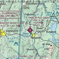
| Sectional chart |
|---|
|
| Airport distance calculator |
|---|
|
|
| Sunrise and sunset |
|---|
|
Times for 22-May-2026
| | Local
(UTC-4) | | Zulu
(UTC) |
|---|
| Morning civil twilight | | 04:45 | | 08:45 |
| Sunrise | | 05:19 | | 09:19 |
| Sunset | | 20:12 | | 00:12 |
| Evening civil twilight | | 20:46 | | 00:46 |
|
| Current date and time |
|---|
| Zulu (UTC) | 23-May-2026 03:35:29 |
|---|
| Local (UTC-4) | 22-May-2026 23:35:29 |
|---|
|
| METAR |
|---|
KVSF
15nm W | 230254Z AUTO 00000KT 10SM CLR 09/03 A3041 RMK AO2 SLP300 T00890033 51018
|
KLEB
16nm N | 230253Z AUTO 00000KT 10SM CLR 08/04 A3039 RMK AO2 SLP291 T00830044 51020
|
|
| TAF |
|---|
KLEB
16nm N | 221722Z 2218/2318 35010KT P6SM SCT250 FM230000 VRB03KT P6SM SCT250 FM231500 VRB05KT P6SM OVC250
|
|
| NOTAMs |
|---|
NOTAMs are issued by the DoD/FAA and will open in a separate window not controlled by AirNav.
|
|

