FAA INFORMATION EFFECTIVE 14 MAY 2026
Location
| FAA Identifier: | 2D5 |
| Lat/Long: | 46-10-23.8660N 098-04-48.1390W
46-10.397767N 098-04.802317W
46.1732961,-98.0800386
(estimated) |
| Elevation: | 1334.9 ft. / 407 m (estimated) |
| Variation: | 07E (1995) |
| From city: | 2 miles N of OAKES, ND |
| Time zone: | UTC -5 (UTC -6 during Standard Time) |
| Zip code: | 58474 |
Airport Operations
| Airport use: | Open to the public |
| Activation date: | 09/1981 |
| Control tower: | no |
| ARTCC: | MINNEAPOLIS CENTER |
| FSS: | GRAND FORKS FLIGHT SERVICE STATION |
| NOTAMs facility: | GFK (NOTAM-D service available) |
| Attendance: | ON CALL
ON CALL AFTER HRS 701-710-1220. |
| Wind indicator: | lighted |
| Segmented circle: | yes |
| Lights: | ACTVT MIRL RY 12/30 & PAPI RYS 12 & 30 - CTAF. |
| Beacon: | white-green (lighted land airport)
Operates sunset to sunrise. |
Airport Communications
| CTAF: | 122.9 |
| WX AWOS-3: | 118.675 (701-742-3991) |
| WX AWOS-3 at GWR (18 nm E): | 118.325 (701-678-6801) |
- APCH/DEP SVC PRVDD BY MINNEAPOLIS ARTCC ON FREQS 124.2/270.3 (WOODWORTH RCAG).
Airport Services
| Parking: | hangars and tiedowns |
| Airframe service: | MINOR |
| Powerplant service: | MINOR |
Runway Information
Runway 12/30
| Dimensions: | 3505 x 60 ft. / 1068 x 18 m |
| Surface: | asphalt, in good condition |
| Weight bearing capacity: | |
| Runway edge lights: | medium intensity |
| RUNWAY 12 | | RUNWAY 30 |
| Latitude: | 46-10.648567N | | 46-10.266667N |
| Longitude: | 098-05.128217W | | 098-04.506283W |
| Elevation: | 1330.4 ft. | | 1334.9 ft. |
| Traffic pattern: | left | | left |
| Runway heading: | 124 magnetic, 131 true | | 304 magnetic, 311 true |
| Markings: | nonprecision, in good condition | | nonprecision, in good condition |
| Visual slope indicator: | 2-light PAPI on left (3.00 degrees glide path) | | 2-light PAPI on left (3.00 degrees glide path) |
| Touchdown point: | yes, no lights | | yes, no lights |
| Obstructions: | 14 ft. other, 300 ft. from runway, 265 ft. left of centerline, 7:1 slope to clear
MOBILE IRRIGATOR INTMTLY IN APCH L & R OF CNTRLN. | | none |
Helipad H1
| Dimensions: | 60 x 60 ft. / 18 x 18 m |
| Surface: | concrete, in good condition |
| Latitude: | 46-10.572500N | | |
| Longitude: | 098-05.292500W | | |
| Elevation: | 1322.0 ft. | | |
| Traffic pattern: | left | | left |
| Markings: | basic, in fair condition | | |
Runway 17/35
| Dimensions: | 2001 x 120 ft. / 610 x 37 m |
| Surface: | turf, in good condition |
| RUNWAY 17 | | RUNWAY 35 |
| Latitude: | 46-10.457500N | | 46-10.128333N |
| Longitude: | 098-04.775833W | | 098-04.776500W |
| Elevation: | 1333.5 ft. | | 1332.7 ft. |
| Traffic pattern: | left | | left |
| Runway heading: | 173 magnetic, 180 true | | 353 magnetic, 000 true |
| Markings: | none | | none |
| Touchdown point: | yes, no lights | | yes, no lights |
Airport Ownership and Management from official FAA records
| Ownership: | Publicly-owned |
| Owner: | OAKES ARPT AUTH
115 SOUTH 5TH ST
OAKES, ND 58474
Phone 701-742-2137
ARPT AUTHORITY CLERK. |
| Manager: | TRAVIS MCPHERSON
8550 HWY 1
OAKES, ND 58474
Phone 701-710-1220
ADL CONTACT GARY SCHNELL 701-678-4910, DEAN SCHMIT 701-678-4661, SCOTT GERMAN 701-710-0624. |
Additional Remarks
| - | CFM ARPT CONDS WINTER MONTHS BFR USE CALL 701-710-1220 OR 701-678-4661. |
| - | RWY 17/35 CLSD WINTER MONTHS NO SNOW REMOVAL. |
| - | FBO HRS MON-FRI 0800-1700 FREQ 122.9. |
| - | FOR CD CTC MINNEAPOLIS ARTCC AT 651-463-5588. |
Instrument Procedures
NOTE: All procedures below are presented as PDF files. If you need a reader for these files, you should download the free Adobe Reader.NOT FOR NAVIGATION. Please procure official charts for flight.
FAA instrument procedures published for use from 14 May 2026 at 0901Z to 11 June 2026 at 0900Z.
IAPs - Instrument Approach Procedures |
|---|
| RNAV (GPS) RWY 30 | |
download (193KB) |
| NOTE: Special Take-Off Minimums/Departure Procedures apply | |
download (417KB) |
Other nearby airports with instrument procedures:
KGWR - Gwinner Airport/Roger Melroe Field (18 nm E)
4E7 - Ellendale Municipal Airport (20 nm SW)
6L3 - Lisbon Municipal Airport (22 nm NE)
KBTN - Britton Municipal Airport (26 nm SE)
51D - Edgeley Municipal Airport (29 nm W)
|
|

Road maps at:
MapQuest
Bing
Google
| Aerial photo |
|---|
WARNING: Photo may not be current or correct

Do you have a better or more recent aerial photo of Oakes Municipal Airport that you would like to share? If so, please send us your photo.
|
| Sectional chart |
|---|
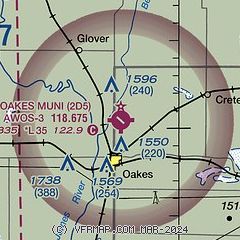
|
| Airport distance calculator |
|---|
|
|
| Sunrise and sunset |
|---|
|
Times for 22-May-2026
| | Local
(UTC-5) | | Zulu
(UTC) |
|---|
| Morning civil twilight | | 05:17 | | 10:17 |
| Sunrise | | 05:53 | | 10:53 |
| Sunset | | 21:05 | | 02:05 |
| Evening civil twilight | | 21:41 | | 02:41 |
|
| Current date and time |
|---|
| Zulu (UTC) | 22-May-2026 11:59:22 |
|---|
| Local (UTC-5) | 22-May-2026 06:59:22 |
|---|
|
| METAR |
|---|
| K2D5 | 221155Z AUTO 10009KT CLR 08/05 A2998 RMK AO2
|
KGWR
18nm E | 221135Z AUTO 11006KT 9SM CLR 08/08 A2999 RMK A01
|
|
| TAF |
|---|
KABR
46nm S | 220520Z 2206/2306 14011KT P6SM SCT240 FM221400 11013G22KT P6SM VCSH OVC018 FM221600 10014G24KT 2SM SHRA BR OVC007 FM222200 12012G20KT P6SM VCSH OVC007 FM230100 06011G17KT P6SM OVC011 FM230200 30011G18KT P6SM BKN011
|
|
| NOTAMs |
|---|
NOTAMs are issued by the DoD/FAA and will open in a separate window not controlled by AirNav.
|
|

