FAA INFORMATION EFFECTIVE 04 SEPTEMBER 2025
Location
| FAA Identifier: | BTN |
| Lat/Long: | 45-48-54.1000N 097-44-34.1000W
45-48.901667N 097-44.568333W
45.8150278,-97.7428056
(estimated) |
| Elevation: | 1318.4 ft. / 401.8 m (surveyed) |
| Variation: | 04E (2015) |
| From city: | 2 miles N of BRITTON, SD |
| Time zone: | UTC -5 (UTC -6 during Standard Time) |
| Zip code: | 57430 |
Airport Operations
| Airport use: | Open to the public |
| Activation date: | 05/1946 |
| Control tower: | no |
| ARTCC: | MINNEAPOLIS CENTER |
| FSS: | HURON FLIGHT SERVICE STATION |
| NOTAMs facility: | HON (NOTAM-D service available) |
| Attendance: | MON-FRI DAYLIGHT HOURS |
| Wind indicator: | lighted |
| Segmented circle: | no |
| Lights: | ACTVT MIRL, REIL & PAPI RYS 13 & 31 - CTAF. |
| Beacon: | white-green (lighted land airport)
Operates sunset to sunrise. |
Airport Communications
| CTAF/UNICOM: | 122.8 |
| WX AWOS-3P: | 118.275 (605-448-2110) |
- AUTOMATED UNICOM.
- APCH/DEP SVC PRVDD BY MINNEAPOLIS ARTCC ON FREQS 120.6/371.9 (ABERDEEN RCAG).
Nearby radio navigation aids
| VOR radial/distance | | VOR name | | Freq | | Var |
|---|
| ABRr041/35.5 | | ABERDEEN VOR/DME | | 113.00 | | 07E |
Airport Services
| Fuel available: | 100LL JET-A
100LL:FUEL AVBL 24 HRS WITH CREDIT CARD |
| Parking: | hangars and tiedowns |
| Airframe service: | MINOR |
| Powerplant service: | MINOR |
| Bottled oxygen: | NONE |
| Bulk oxygen: | NONE |
Runway Information
Runway 13/31
| Dimensions: | 4210 x 75 ft. / 1283 x 23 m |
| Surface: | asphalt, in good condition |
| Weight bearing capacity: | |
| Runway edge lights: | medium intensity |
| RUNWAY 13 | | RUNWAY 31 |
| Latitude: | 45-49.102865N | | 45-48.614125N |
| Longitude: | 097-44.867137W | | 097-44.165355W |
| Elevation: | 1314.6 ft. | | 1318.4 ft. |
| Traffic pattern: | left | | left |
| Runway heading: | 131 magnetic, 135 true | | 311 magnetic, 315 true |
| Markings: | nonprecision, in good condition | | nonprecision, in good condition |
| Visual slope indicator: | 2-light PAPI on left (3.00 degrees glide path) | | 2-light PAPI on left (3.20 degrees glide path) |
| Runway end identifier lights: | yes | | yes |
| Touchdown point: | yes, no lights | | yes, no lights |
| Obstructions: | 15 ft. road, 800 ft. from runway, 40:1 slope to clear | | 88 ft. trees, 1990 ft. from runway, 20:1 slope to clear |
Runway 1/19
| Dimensions: | 2034 x 120 ft. / 620 x 37 m |
| Surface: | turf, in good condition |
| Runway edge markings: | NSTD MKGS: RY 01/19 MARKED WITH BLACK AND WHITE CONES. |
| RUNWAY 1 | | RUNWAY 19 |
| Latitude: | 45-48.839177N | | 45-49.146405N |
| Longitude: | 097-44.769650W | | 097-44.579987W |
| Elevation: | 1312.4 ft. | | 1312.6 ft. |
| Traffic pattern: | left | | left |
| Runway heading: | 019 magnetic, 023 true | | 199 magnetic, 203 true |
| Markings: | NSTD | | NSTD |
| Runway end identifier lights: | no | | no |
| Touchdown point: | yes, no lights | | yes, no lights |
| Obstructions: | 6 ft. fence, 125 ft. from runway, 20:1 slope to clear
HAS +6' FENCE POST 98' FM CNTRLN OF RY. | | 18 ft. road, 390 ft. from runway, 21:1 slope to clear |
Airport Ownership and Management from official FAA records
| Ownership: | Publicly-owned |
| Owner: | CITY OF BRITTON
803 8TH ST
BRITTON, SD 57430
Phone 605-448-5721 |
| Manager: | RYAN FURMAN
PO BOX 941
BRITTON, SD 57430
Phone (605) 470-0485 |
Additional Remarks
| - | RY 19 +6 FT FENCE 190 FT FM THLD. |
| - | WATERFOWL AND GULLS ON & INVOF ARPT. |
| - | GCO AVBL ON FREQ 121.725 (4 CLICKS TO MINNEAPOLIS CENTER AND 6 CLICKS TO FLT SVCS) |
| - | WILDLIFE ON AND AROUND AIRPORT |
| - | FOR CD IF UNA VIA GCO CTC MINNEAPOLIS ARTCC AT 651-463-5588. |
Instrument Procedures
NOTE: All procedures below are presented as PDF files. If you need a reader for these files, you should download the free Adobe Reader.NOT FOR NAVIGATION. Please procure official charts for flight.
FAA instrument procedures published for use from 04 September 2025 at 0901Z to 02 October 2025 at 0900z.
IAPs - Instrument Approach Procedures |
|---|
| RNAV (GPS) RWY 13 | |
download (208KB) |
| RNAV (GPS) RWY 31 | |
download (214KB) |
| NOTE: Special Alternate Minimums apply | |
download (175KB) |
| NOTE: Special Take-Off Minimums/Departure Procedures apply | |
download (156KB) |
Other nearby airports with instrument procedures:
KGWR - Gwinner Airport/Roger Melroe Field (25 nm N)
2D5 - Oakes Municipal Airport (26 nm NW)
8D3 - Sisseton Municipal Airport (33 nm E)
4E7 - Ellendale Municipal Airport (34 nm W)
KABR - Aberdeen Regional Airport (36 nm SW)
|
|

Road maps at:
MapQuest
Bing
Google
| Aerial photo |
|---|
WARNING: Photo may not be current or correct
 Photo by Mark Wismer
Taken in September 2010
looking west.
Photo by Mark Wismer
Taken in September 2010
looking west.
Do you have a better or more recent aerial photo of Britton Municipal Airport that you would like to share? If so, please send us your photo.
|
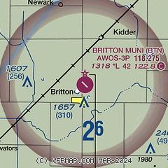
| Sectional chart |
|---|
|
| Airport distance calculator |
|---|
|
|
| Sunrise and sunset |
|---|
|
Times for 22-Sep-2025
| | Local
(UTC-5) | | Zulu
(UTC) |
|---|
| Morning civil twilight | | 06:49 | | 11:49 |
| Sunrise | | 07:19 | | 12:19 |
| Sunset | | 19:28 | | 00:28 |
| Evening civil twilight | | 19:58 | | 00:58 |
|
| Current date and time |
|---|
| Zulu (UTC) | 22-Sep-2025 15:58:17 |
|---|
| Local (UTC-5) | 22-Sep-2025 10:58:17 |
|---|
|
| METAR |
|---|
| KBTN | SuperAWOS
221535Z AUTO 00000KT 6SM HZ CLR 20/16 A2981 RMK AO2
|
|
| TAF |
|---|
KABR
36nm SW | 221127Z 2212/2312 VRB03KT P6SM SKC TEMPO 2212/2214 4SM BR FM221400 06007KT P6SM SKC FM230100 VRB03KT P6SM SKC
|
|
| NOTAMs |
|---|
NOTAMs are issued by the DoD/FAA and will open in a separate window not controlled by AirNav.
|
|

