FAA INFORMATION EFFECTIVE 14 MAY 2026
Location
| FAA Identifier: | 4E7 |
| Lat/Long: | 46-00-58.8000N 098-30-56.5000W
46-00.980000N 098-30.941667W
46.0163333,-98.5156944
(estimated) |
| Elevation: | 1456.6 ft. / 444.0 m (surveyed) |
| Variation: | 07E (1985) |
| From city: | 1 mile NE of ELLENDALE, ND |
| Time zone: | UTC -5 (UTC -6 during Standard Time) |
| Zip code: | 58436 |
Airport Operations
| Airport use: | Open to the public |
| Activation date: | 11/1947 |
| Control tower: | no |
| ARTCC: | MINNEAPOLIS CENTER |
| FSS: | GRAND FORKS FLIGHT SERVICE STATION |
| NOTAMs facility: | GFK (NOTAM-D service available) |
| Attendance: | UNATNDD |
| Wind indicator: | lighted |
| Segmented circle: | yes |
| Lights: | ACTVT MIRL RWY 13/31; PAPI RWY 13 & 31 - CTAF. |
| Beacon: | white-green (lighted land airport)
Operates sunset to sunrise. |
Airport Communications
- APCH/DEP SVC PRVDD BY MINNEAPOLIS ARTCC ON FREQS 124.2/270.3 (WOODWORTH RCAG).
Nearby radio navigation aids
| VOR radial/distance | | VOR name | | Freq | | Var |
|---|
| ABRr343/36.5 | | ABERDEEN VOR/DME | | 113.00 | | 07E |
Airport Services
| Fuel available: | 100LL
100LL:SELF SVC AVBL H24 VIA CREDIT CARD. |
| Parking: | hangars and tiedowns |
| Airframe service: | NONE |
| Powerplant service: | NONE |
| Bottled oxygen: | NONE |
| Bulk oxygen: | NONE |
Runway Information
Runway 13/31
| Dimensions: | 3499 x 60 ft. / 1066 x 18 m |
| Surface: | asphalt, in good condition |
| Weight bearing capacity: | |
| Runway edge lights: | medium intensity |
| RUNWAY 13 | | RUNWAY 31 |
| Latitude: | 46-01.247797N | | 46-00.798657N |
| Longitude: | 098-31.132620W | | 098-30.615823W |
| Elevation: | 1456.4 ft. | | 1456.1 ft. |
| Traffic pattern: | left | | left |
| Runway heading: | 134 magnetic, 141 true | | 314 magnetic, 321 true |
| Markings: | nonprecision, in fair condition | | nonprecision, in fair condition |
| Visual slope indicator: | 2-light PAPI on left (3.00 degrees glide path) | | 2-light PAPI on left (3.00 degrees glide path) |
| Touchdown point: | yes, no lights | | yes, no lights |
Runway 17/35
| Dimensions: | 2437 x 126 ft. / 743 x 38 m |
| Surface: | turf, in good condition |
| Operational restrictions: | CLSD DRG WINTER MONTHS DUE TO LACK OF SNOW REMOVAL. |
| RUNWAY 17 | | RUNWAY 35 |
| Latitude: | 46-01.117243N | | 46-00.716247N |
| Longitude: | 098-31.036935W | | 098-31.039690W |
| Elevation: | 1453.9 ft. | | 1453.9 ft. |
| Traffic pattern: | left | | left |
| Runway heading: | 173 magnetic, 180 true | | 353 magnetic, 000 true |
| Touchdown point: | yes, no lights | | yes, no lights |
Airport Ownership and Management from official FAA records
| Ownership: | Publicly-owned |
| Owner: | ELLENDALE ARPT AUTH
BOX 82
ELLENDALE, ND 58436
Phone 701-830-0143
KYLE GLYNN, CHAIRMAN ARPT AUTH. |
| Manager: | KYLE GLYNN
8974 HWY 281
ELLENDALE, ND 58436
Phone 701-830-0143
ADDL CONTACT JEFF ULMER 701-866-6434. |
Additional Remarks
| A30A-31 | +60 FT ANT 1720 FT FM THLD 340 FT L OF EXTDD CNTRLN. |
| - | FOR RWY CONDS DRG WINTER MONTHS CALL AMGR AT 701-830-0143. |
| - | BIRDS & DEER INVOF ARPT. |
| - | FOR CD CTC MINNEAPOLIS ARTCC AT 651-463-5588. |
Instrument Procedures
NOTE: All procedures below are presented as PDF files. If you need a reader for these files, you should download the free Adobe Reader.NOT FOR NAVIGATION. Please procure official charts for flight.
FAA instrument procedures published for use from 14 May 2026 at 0901Z to 11 June 2026 at 0900Z.
IAPs - Instrument Approach Procedures |
|---|
| RNAV (GPS) RWY 31 | |
download (190KB) |
| NOTE: Special Take-Off Minimums/Departure Procedures apply | |
download (267KB) |
Other nearby airports with instrument procedures:
2D5 - Oakes Municipal Airport (20 nm NE)
51D - Edgeley Municipal Airport (22 nm NW)
KABR - Aberdeen Regional Airport (34 nm S)
KBTN - Britton Municipal Airport (34 nm E)
KASY - Ashley Municipal Airport (35 nm W)
|
|

Road maps at:
MapQuest
Bing
Google
| Aerial photo |
|---|
WARNING: Photo may not be current or correct

Do you have a better or more recent aerial photo of Ellendale Municipal Airport that you would like to share? If so, please send us your photo.
|
| Sectional chart |
|---|
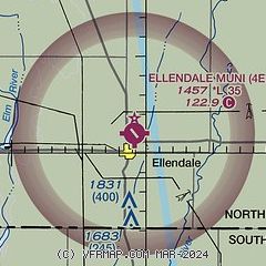
|
| Airport distance calculator |
|---|
|
|
| Sunrise and sunset |
|---|
|
Times for 07-Jun-2026
| | Local
(UTC-5) | | Zulu
(UTC) |
|---|
| Morning civil twilight | | 05:07 | | 10:07 |
| Sunrise | | 05:45 | | 10:45 |
| Sunset | | 21:21 | | 02:21 |
| Evening civil twilight | | 21:59 | | 02:59 |
|
| Current date and time |
|---|
| Zulu (UTC) | 07-Jun-2026 10:56:40 |
|---|
| Local (UTC-5) | 07-Jun-2026 05:56:40 |
|---|
|
| METAR |
|---|
K2D5
20nm NE | 071035Z AUTO 13012KT CLR 20/12 A2970 RMK AO2 LTG DSNT N AND NW
|
KABR
34nm S | 070953Z AUTO 15013KT 10SM CLR 21/14 A2968 RMK AO2 SLP039 T02110144
|
KBTN
34nm E | SuperAWOS
071035Z AUTO 15012G17KT 10SM CLR 22/15 A2970 RMK AO2
|
KGWR
38nm E | 071035Z AUTO 13015KT 10SM CLR 19/18 A2972 RMK A01
|
|
| TAF |
|---|
KABR
34nm S | 070909Z 0709/0806 15012G19KT P6SM SKC FM071600 17021G31KT P6SM FEW060 SCT250 FM080200 15018G29KT P6SM SCT240
|
|
| NOTAMs |
|---|
NOTAMs are issued by the DoD/FAA and will open in a separate window not controlled by AirNav.
|
|

