FAA INFORMATION EFFECTIVE 14 MAY 2026
Location
| FAA Identifier: | 3B1 |
| Lat/Long: | 45-27-46.1930N 069-33-05.9380W
45-27.769883N 069-33.098967W
45.4628314,-69.5516494
(estimated) |
| Elevation: | 1401.8 ft. / 427.3 m (surveyed) |
| Variation: | 18W (1995) |
| From city: | 2 miles E of GREENVILLE, ME |
| Time zone: | UTC -4 (UTC -5 during Standard Time) |
| Zip code: | 04441 |
Airport Operations
| Airport use: | Open to the public |
| Activation date: | 12/1942 |
| Control tower: | no |
| ARTCC: | BOSTON CENTER |
| FSS: | BANGOR FLIGHT SERVICE STATION |
| NOTAMs facility: | BGR (NOTAM-D service available) |
| Attendance: | 0800-1700 |
| Wind indicator: | lighted |
| Segmented circle: | yes |
| Lights: | DUSK-DAWN. ACTVT REIL RWY 14; PAPI RWY 14 & 32; MIRL RWY 14/32 - CTAF. |
| Beacon: | white-green (lighted land airport)
Operates sunset to sunrise. |
Airport Communications
| CTAF/UNICOM: | 122.8 |
| WX AWOS-A: | 124.175 (207-695-2581) |
- APCH/DEP SVC PRVDD BY BOSTON ARTCC ON FREQS 120.25/346.4 (BANGOR RCAG).
- CLNC DEL THRU BANGOR RADIO (BGR) ON FREQ 122.3 (GREENVILLE RCO).
Airport Services
| Fuel available: | 100LL JET-A
100LL:24 HR FUEL AVBL WITH MAJOR CREDIT CARD. |
| Parking: | hangars and tiedowns |
| Airframe service: | MAJOR |
| Powerplant service: | MAJOR |
| Bottled oxygen: | NONE |
| Bulk oxygen: | NONE |
Runway Information
Runway 14/32
| Dimensions: | 4000 x 75 ft. / 1219 x 23 m |
| Surface: | asphalt, in good condition |
| Weight bearing capacity: | |
| Runway edge lights: | medium intensity |
| Runway edge markings: | NRS AND CNTRLN FADED. |
| RUNWAY 14 | | RUNWAY 32 |
| Latitude: | 45-27.904148N | | 45-27.601735N |
| Longitude: | 069-33.458387W | | 069-32.627717W |
| Elevation: | 1384.0 ft. | | 1373.6 ft. |
| Traffic pattern: | left | | left |
| Runway heading: | 135 magnetic, 117 true | | 315 magnetic, 297 true |
| Markings: | nonprecision, in poor condition | | nonprecision, in poor condition |
| Visual slope indicator: | 4-light PAPI on right (3.00 degrees glide path)
PAPI UNUSBL BYD 8 DEGS R OF CNTRLN. | | 4-light PAPI on left (3.10 degrees glide path) |
| Runway end identifier lights: | yes | | no |
| Touchdown point: | yes, no lights | | yes, no lights |
Runway 3/21
| Dimensions: | 3001 x 75 ft. / 915 x 23 m |
| Surface: | asphalt, in excellent condition |
| Weight bearing capacity: | |
| Runway edge markings: | NRS AND CNTRLN FADED. |
| RUNWAY 3 | | RUNWAY 21 |
| Latitude: | 45-27.548923N | | 45-28.036015N |
| Longitude: | 069-33.230685W | | 069-33.116357W |
| Elevation: | 1373.7 ft. | | 1401.8 ft. |
| Traffic pattern: | left | | left |
| Runway heading: | 027 magnetic, 009 true | | 207 magnetic, 189 true |
| Markings: | basic, in poor condition | | basic, in poor condition |
| Runway end identifier lights: | no | | no |
| Touchdown point: | yes, no lights | | yes, no lights |
Airport Ownership and Management from official FAA records
| Ownership: | Publicly-owned |
| Owner: | TOWN OF GREENVILLE
TOWN OFFICE BLDG
GREENVILLE, ME 04441
Phone 207-695-2421 |
| Manager: | MICHAEL ROY
TOWN OFFICE BLDG
GREENVILLE, ME 04441
Phone 207-695-2421
TOWN MGR. |
Additional Remarks
| - | MOOSE, DEER & OTR WILDLIFE ON & INVOF ARPT. |
| - | COLD TEMPERATURE AIRPORT. ALTITUDE CORRECTION REQUIRED AT OR BELOW -20C. |
| - | BE ALERT: MNT CTAF 122.9 FOR LCL SPB TFC NEARBY (52B & 21M) IF ABLE. |
Instrument Procedures
NOTE: All procedures below are presented as PDF files. If you need a reader for these files, you should download the free Adobe Reader.NOT FOR NAVIGATION. Please procure official charts for flight.
FAA instrument procedures published for use from 14 May 2026 at 0901Z to 11 June 2026 at 0900Z.
IAPs - Instrument Approach Procedures |
|---|
| RNAV (GPS) RWY 14 | |
download (279KB) |
| RNAV (GPS) RWY 32 | |
download (289KB) |
| NOTE: Special Take-Off Minimums/Departure Procedures apply | |
download (472KB) |
Other nearby airports with instrument procedures:
52B - Moosehead Aero Marine Seaplane Base (2 nm W)
1B0 - Dexter Regional Airport (31 nm SE)
59B - Newton Field Airport (31 nm W)
B21 - Sugarloaf Regional Airport (36 nm SW)
KMLT - Millinocket Municipal Airport (38 nm E)
|
|

Road maps at:
MapQuest
Bing
Google
| Aerial photo |
|---|
WARNING: Photo may not be current or correct
 Photo by Pete Chaisson Portland Flight Services
Photo taken 07-Sep-2014
looking northeast.
Photo by Pete Chaisson Portland Flight Services
Photo taken 07-Sep-2014
looking northeast.
Do you have a better or more recent aerial photo of Greenville Municipal Airport that you would like to share? If so, please send us your photo.
|
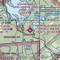
| Sectional chart |
|---|
|
| Airport distance calculator |
|---|
|
|
| Sunrise and sunset |
|---|
|
Times for 05-Jun-2026
| | Local
(UTC-4) | | Zulu
(UTC) |
|---|
| Morning civil twilight | | 04:15 | | 08:15 |
| Sunrise | | 04:52 | | 08:52 |
| Sunset | | 20:21 | | 00:21 |
| Evening civil twilight | | 20:59 | | 00:59 |
|
| Current date and time |
|---|
| Zulu (UTC) | 05-Jun-2026 14:46:03 |
|---|
| Local (UTC-4) | 05-Jun-2026 10:46:03 |
|---|
|
| METAR |
|---|
| KGNR | 051356Z AUTO VRB04KT 19/12 A2995 RMK AO1 SLP138 T01940117
|
|
| NOTAMs |
|---|
NOTAMs are issued by the DoD/FAA and will open in a separate window not controlled by AirNav.
|
|

