FAA INFORMATION EFFECTIVE 09 JULY 2026
Location
| FAA Identifier: | B21 |
| Lat/Long: | 45-05-07.1510N 070-12-58.7610W
45-05.119183N 070-12.979350W
45.0853197,-70.2163225
(estimated) |
| Elevation: | 880 ft. / 268.2 m (surveyed) |
| Variation: | 17W (2005) |
| From city: | 1 mile N of CARRABASSETT, ME |
| Time zone: | UTC -4 (UTC -5 during Standard Time) |
| Zip code: | 04947 |
Airport Operations
| Airport use: | Open to the public |
| Control tower: | no |
| ARTCC: | BOSTON CENTER |
| FSS: | BANGOR FLIGHT SERVICE STATION |
| NOTAMs facility: | BGR (NOTAM-D service available) |
| Attendance: | UNATNDD |
| Pattern altitude: | 2880 ft. MSL |
| Wind indicator: | yes |
| Segmented circle: | yes |
Airport Communications
| CTAF/UNICOM: | 122.8 |
| WX AWOS-AV: | 120.0 |
| WX AWOS-3PT at 8B0 (20 nm W): | 118.000 (207-864-5250) |
- APCH/DEP SVC PRVDD BY BOSTON ARTCC ON FREQS 120.25/346.4 (BANGOR RCAG).
Airport Services
| Fuel available: | 100LL MOGAS |
| Parking: | tiedowns |
| Airframe service: | NONE |
| Powerplant service: | NONE |
| Bottled oxygen: | NONE |
| Bulk oxygen: | NONE |
Runway Information
Runway 17/35
| Dimensions: | 2797 x 75 ft. / 853 x 23 m |
| Surface: | asphalt, in good condition |
| Weight bearing capacity: | |
| RUNWAY 17 | | RUNWAY 35 |
| Latitude: | 45-05.317420N | | 45-04.920947N |
| Longitude: | 070-13.144373W | | 070-12.814342W |
| Elevation: | 880.0 ft. | | 856.9 ft. |
| Traffic pattern: | left | | left |
| Runway heading: | 166 magnetic, 149 true | | 346 magnetic, 329 true |
| Displaced threshold: | no | | 89 ft. |
| Markings: | basic, in good condition | | basic, in good condition |
| Touchdown point: | yes, no lights | | yes, no lights |
| Obstructions: | 10 ft. road, 200 ft. from runway, 85 ft. left of centerline
+10 FT ROADWAY 100-200 FT FM THR, 85-125 FT L OF CNTRLN. | | 53 ft. bldg, 316 ft. from runway, 160 ft. right of centerline, 2:1 slope to clear |
Airport Ownership and Management from official FAA records
| Ownership: | Publicly-owned |
| Owner: | TOWN OF CARRABASSETT
1001 CARRIAGE RD
CARRABASSETT VALLEY, ME 04947
Phone 207-235-2646 |
| Manager: | TOM WALLACE
1001 CARRIAGE RD
CARRABASSETT VALLEY, ME 04947
Phone 207-350-1415
ADDNL CTC: TOM WALLACE AT TLWCFII@YAHOO.COM. |
Additional Remarks
| - | HIGH TRRN 4237 FT MSL NORTH/EAST/WEST OF ARPT. |
| - | CALL 207-350-1415 TO CK ARPT CONDS. |
| - | DEER, MOOSE & TURKEY ON & INVOF ARPT. |
| - | FOR CD CTC BOSTON ARTCC AT 603-879-6859. |
Instrument Procedures
NOTE: All procedures below are presented as PDF files. If you need a reader for these files, you should download the free Adobe Reader.NOT FOR NAVIGATION. Please procure official charts for flight.
FAA instrument procedures published for use from 09 July 2026 at 0901Z to 06 August 2026 at 0900Z.
IAPs - Instrument Approach Procedures |
|---|
| RNAV (GPS)-A | |
download (174KB) |
| NOTE: Special Take-Off Minimums/Departure Procedures apply | |
download (949KB) |
Other nearby airports with instrument procedures:
8B0 - Stephen A Bean Municipal Airport (20 nm W)
M57 - Rangeley Lake Seaplane Base (21 nm SW)
KOWK - Central Maine/Norridgewock Airport (27 nm SE)
59B - Newton Field Airport (33 nm N)
52B - Moosehead Aero Marine Seaplane Base (35 nm NE)
|
|

Road maps at:
MapQuest
Bing
Google
| Aerial photo |
|---|
WARNING: Photo may not be current or correct

Do you have a better or more recent aerial photo of Sugarloaf Regional Airport that you would like to share? If so, please send us your photo.
|
| Sectional chart |
|---|
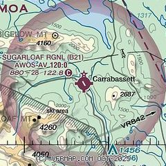
|
| Airport distance calculator |
|---|
|
|
| Sunrise and sunset |
|---|
|
Times for 31-Jul-2026
| | Local
(UTC-4) | | Zulu
(UTC) |
|---|
| Morning civil twilight | | 04:52 | | 08:52 |
| Sunrise | | 05:26 | | 09:26 |
| Sunset | | 20:09 | | 00:09 |
| Evening civil twilight | | 20:43 | | 00:43 |
|
| Current date and time |
|---|
| Zulu (UTC) | 31-Jul-2026 13:04:59 |
|---|
| Local (UTC-4) | 31-Jul-2026 09:04:59 |
|---|
|
| METAR |
|---|
K8B0
22nm W | 311255Z AUTO 35006KT 10SM SCT016 OVC095 18/14 A2997 RMK AO2
|
KGNR
36nm NE | 311256Z AUTO 34006KT 17/16 A2991 RMK AO1 SLP130 T01720156
|
KWVL
41nm SE | 311256Z AUTO 34006KT 10SM OVC026 19/17 A2989 RMK AO2 SLP126 T01940167
|
|
| TAF |
|---|
KAUG
49nm S | 311120Z 3112/0112 32004KT P6SM OVC100 FM010900 36002KT 2SM BR SCT003
|
|
| NOTAMs |
|---|
NOTAMs are issued by the DoD/FAA and will open in a separate window not controlled by AirNav.
|
|

