FAA INFORMATION EFFECTIVE 22 JANUARY 2026
Location
| FAA Identifier: | 3DA |
| Lat/Long: | 43-03-24.6265N 083-48-16.5603W
43-03.410442N 083-48.276005W
43.0568407,-83.8046001
(estimated) |
| Elevation: | 733 ft. / 223.4 m (surveyed) |
| Variation: | 05W (1985) |
| From city: | 2 miles E of FLUSHING, MI |
| Time zone: | UTC -5 (UTC -4 during Daylight Saving Time) |
| Zip code: | 48433 |
Airport Operations
| Airport use: | Open to the public |
| Activation date: | 09/1946 |
| Control tower: | no |
| ARTCC: | CLEVELAND CENTER |
| FSS: | LANSING FLIGHT SERVICE STATION |
| NOTAMs facility: | LAN (NOTAM-D service available) |
| Attendance: | IREG IREG |
| Wind indicator: | yes |
| Segmented circle: | no |
| Lights: | ACTVT LIRL RWY 18/36 - CTAF. |
| Beacon: | white-green (lighted land airport)
Operates sunset to sunrise. |
Airport Communications
| CTAF/UNICOM: | 122.8 |
| WX ASOS at FNT (6 nm SE): | PHONE 810-202-2914 |
| WX AWOS-3 at RNP (15 nm W): | 118.025 (989-729-2967) |
Nearby radio navigation aids
| VOR radial/distance | | VOR name | | Freq | | Var |
|---|
| FNTr341/6.0 | | FLINT VORTAC | | 116.90 | | 06W |
| MBSr160/30.9 | | SAGINAW VOR/DME | | 114.35 | | 03W |
| SVMr350/40.0 | | SALEM VORTAC | | 114.30 | | 03W |
Airport Services
| Fuel available: | 100LL
100LL:FUEL AVBL VIA CREDIT CARD. |
| Parking: | tiedowns |
| Bottled oxygen: | NONE |
| Bulk oxygen: | NONE |
Runway Information
Runway 18/36
| Dimensions: | 2510 x 50 ft. / 765 x 15 m |
| Surface: | asphalt, in fair condition |
| Runway edge lights: | low intensity |
| RUNWAY 18 | | RUNWAY 36 |
| Latitude: | 43-03.604000N | | 43-03.191000N |
| Longitude: | 083-48.235667W | | 083-48.218000W |
| Elevation: | 733.0 ft. | | 733.0 ft. |
| Traffic pattern: | left | | left |
| Runway heading: | 183 magnetic, 178 true | | 003 magnetic, 358 true |
| Displaced threshold: | 771 ft. | | 771 ft. |
| Markings: | basic, in fair condition | | basic, in fair condition |
| Runway end identifier lights: | no | | no |
| Obstructions: | 43 ft. tree, 221 ft. from runway, 125 ft. right of centerline
+32 FT TREES, 131 FT DIST; PLINE & ROAD. | | 57 ft. trees, 324 ft. from runway, 50 ft. right of centerline, 2:1 slope to clear
APCH RATIO 18:1 TO DTHR OVR +71 FT TREE, 1287 FT DIST, 0 FT B. |
Runway 9/27
| Dimensions: | 1633 x 130 ft. / 498 x 40 m |
| Surface: | turf, in good condition |
| Runway edge markings: | RWY & DTHR MKD WITH 3 FT YELLOW CONES. |
| Operational restrictions: | CLSD OCT-MAR. |
| RUNWAY 9 | | RUNWAY 27 |
| Latitude: | 43-03.428000N | | 43-03.432667N |
| Longitude: | 083-48.534833W | | 083-48.168333W |
| Elevation: | 727.0 ft. | | 730.0 ft. |
| Traffic pattern: | left | | left |
| Runway heading: | 094 magnetic, 089 true | | 274 magnetic, 269 true |
| Displaced threshold: | no | | 293 ft. |
| Runway end identifier lights: | no | | no |
| Obstructions: | 34 ft. tree, 423 ft. from runway, 70 ft. left of centerline, 12:1 slope to clear | | 22 ft. road, 48 ft. from runway, 125 ft. left and right of centerline, 2:1 slope to clear
APCH RATIO 15:1 TO DTHR OVR 49 FT TREE, 770 FT DIST, 42 FT R. |
Airport Ownership and Management from official FAA records
| Ownership: | Privately-owned |
| Owner: | DALTON AIRPORT ASSOCIATION
PO BOX 310693
FLINT, MI 48531-0693
Phone 810-736-7231 |
| Manager: | BILL CAMPEAU
PO BOX 310693
FLINT, MI 48531-0693
Phone 810-736-7231 |
Additional Remarks
| - | FOR CD CTC GREAT LAKES APCH AT 269-459-3345, WHEN APCH CLSD CTC CLEVELAND ARTCC AT 440-774-0224/0490. |
| - | DEER & LRG BIRDS ON & INVOF ARPT. |
Instrument Procedures
There are no published instrument procedures at 3DA.
Some nearby airports with instrument procedures:
KFNT - Bishop International Airport (6 nm SE)
9G2 - Price's Airport (15 nm S)
KRNP - Owosso Community Airport (15 nm W)
KHYX - Saginaw County/H W Browne Airport (23 nm N)
D95 - Dupont/Lapeer Airport (23 nm E)
|
|

Road maps at:
MapQuest
Bing
Google
| Aerial photo |
|---|
WARNING: Photo may not be current or correct

Do you have a better or more recent aerial photo of Dalton Airport that you would like to share? If so, please send us your photo.
|
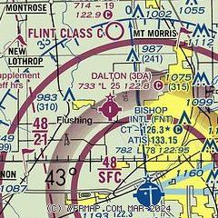
| Sectional chart |
|---|
|
| Airport distance calculator |
|---|
|
|
| Sunrise and sunset |
|---|
|
Times for 09-Feb-2026
| | Local
(UTC-5) | | Zulu
(UTC) |
|---|
| Morning civil twilight | | 07:12 | | 12:12 |
| Sunrise | | 07:42 | | 12:42 |
| Sunset | | 17:57 | | 22:57 |
| Evening civil twilight | | 18:27 | | 23:27 |
|
| Current date and time |
|---|
| Zulu (UTC) | 09-Feb-2026 18:09:08 |
|---|
| Local (UTC-5) | 09-Feb-2026 13:09:08 |
|---|
|
| METAR |
|---|
KFNT
6nm SE | 091753Z 17006KT 10SM OVC055 M04/M14 A3018 RMK AO2 SLP235 T10441144 11044 21156 58029
|
KRNP
15nm W | 091755Z AUTO 18009KT 10SM OVC060 M04/M14 A3017 RMK AO2 T10431145 11043 21130
|
|
| TAF |
|---|
KFNT
6nm SE | 091737Z 0918/1018 15007KT P6SM OVC060 FM092000 15007KT P6SM BKN060 OVC120 FM100200 17005KT P6SM SCT060 BKN120 OVC200 FM101400 22009KT P6SM BKN025
|
|
| NOTAMs |
|---|
NOTAMs are issued by the DoD/FAA and will open in a separate window not controlled by AirNav.
|
|

