FAA INFORMATION EFFECTIVE 22 JANUARY 2026
Location
| FAA Identifier: | 4M2 |
| Lat/Long: | 35-08-58.2948N 093-51-48.2024W
35-08.971580N 093-51.803373W
35.1495263,-93.8633896
(estimated) |
| Elevation: | 467.8 ft. / 142.6 m (surveyed) |
| Variation: | 05E (1985) |
| From city: | 3 miles E of BOONEVILLE, AR |
| Time zone: | UTC -6 (UTC -5 during Daylight Saving Time) |
| Zip code: | 72927 |
Airport Operations
| Airport use: | Open to the public |
| Activation date: | 06/1966 |
| Control tower: | no |
| ARTCC: | MEMPHIS CENTER |
| FSS: | JONESBORO FLIGHT SERVICE STATION |
| NOTAMs facility: | JBR (NOTAM-D service available) |
| Attendance: | MON-FRI 0800-1700 |
| Wind indicator: | yes |
| Segmented circle: | yes |
| Lights: | ACTVT MIRL RY 09/27 - CTAF. |
| Beacon: | white-green (lighted land airport)
Operates sunset to sunrise. |
Airport Communications
Nearby radio navigation aids
| VOR radial/distance | | VOR name | | Freq | | Var |
|---|
| FSMr119/24.6 | | FORT SMITH VORTAC | | 110.40 | | 07E |
| NDB name | | Hdg/Dist | | Freq | | Var | | ID |
|---|
| RUSSELLVILLE | | 257/38.2 | | 379 | | 03E | | RUE | .-. ..- . |
Airport Services
| Fuel available: | 100LL
100LL:SELF-SERVE FUEL AVBL 24 HRS WITH CREDIT CARD. |
| Parking: | hangars and tiedowns |
| Airframe service: | MAJOR |
| Powerplant service: | MAJOR |
| Bottled oxygen: | NONE |
| Bulk oxygen: | NONE |
Runway Information
Runway 9/27
| Dimensions: | 3254 x 50 ft. / 992 x 15 m |
| Surface: | asphalt, in fair condition |
| Runway edge lights: | medium intensity |
| RUNWAY 9 | | RUNWAY 27 |
| Latitude: | 35-08.976210N | | 35-08.966948N |
| Longitude: | 093-52.129762W | | 093-51.476983W |
| Elevation: | 466.0 ft. | | 446.5 ft. |
| Traffic pattern: | left | | left |
| Runway heading: | 086 magnetic, 091 true | | 266 magnetic, 271 true |
| Markings: | basic, in good condition | | basic, in good condition |
| Touchdown point: | yes, no lights | | yes, no lights |
| Obstructions: | 48 ft. trees, 550 ft. from runway, 200 ft. right of centerline, 7:1 slope to clear | | 15 ft. trees, 250 ft. from runway, 3:1 slope to clear |
Airport Ownership and Management from official FAA records
| Ownership: | Publicly-owned |
| Owner: | CITY OF BOONVILLE
CITY HALL 497 EAST MAIN, SUITE A
BOONEVILLE, AR 72927
Phone 479-675-3811 |
| Manager: | BILL TUCKER
PO BOX 912
BOONEVILLE, AR 72927
Phone 479-518-5890 |
Additional Remarks
| - | FOR CD CTC RAZORBACK APCH AT 479-649-2416, WHEN APCH CLSD CTC MEMPHIS ARTCC AT 901-368-8453/8449. |
Instrument Procedures
There are no published instrument procedures at 4M2.
Some nearby airports with instrument procedures:
32A - Danville Municipal Airport (22 nm E)
7M5 - Ozark/Franklin County Airport (22 nm N)
KFSM - Fort Smith Regional Airport (27 nm NW)
H35 - Clarksville Municipal Airport (29 nm NE)
KRKR - Robert S Kerr Airport (38 nm W)
|
|

Road maps at:
MapQuest
Bing
Google
| Aerial photo |
|---|
WARNING: Photo may not be current or correct
 Photo courtesy of the Arkansas Department of Aeronautics
Taken in the Spring of 2007
Photo courtesy of the Arkansas Department of Aeronautics
Taken in the Spring of 2007
Do you have a better or more recent aerial photo of Booneville Municipal Airport that you would like to share? If so, please send us your photo.
|
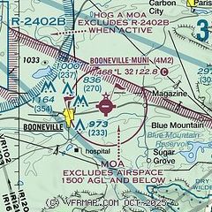
| Sectional chart |
|---|
|
| Airport distance calculator |
|---|
|
|
| Sunrise and sunset |
|---|
|
Times for 10-Feb-2026
| | Local
(UTC-6) | | Zulu
(UTC) |
|---|
| Morning civil twilight | | 06:42 | | 12:42 |
| Sunrise | | 07:08 | | 13:08 |
| Sunset | | 17:52 | | 23:52 |
| Evening civil twilight | | 18:18 | | 00:18 |
|
| Current date and time |
|---|
| Zulu (UTC) | 10-Feb-2026 21:18:06 |
|---|
| Local (UTC-6) | 10-Feb-2026 15:18:06 |
|---|
|
| METAR |
|---|
KFSM
27nm NW | 102053Z AUTO 23015G20KT 10SM BKN120 24/13 A2990 RMK AO2 SLP122 T02390128 56015
|
KRKR
38nm W | 102055Z AUTO 21012G16KT 10SM BKN120 23/12 A2994 RMK AO2
|
KRUE
38nm E | 102053Z AUTO 24010G25KT 10SM FEW120 22/12 A2991 RMK AO2 PK WND 24026/2029 SLP124 T02220122 56016 TSNO $
|
KMWT
39nm S | 102053Z AUTO 10SM BKN100 OVC110 21/14 A2993 RMK AO2 SLP129 T02110144 56014 $
|
KMEZ
40nm SW | 102055Z AUTO 23006KT 8SM -RA CLR 19/15 A2994 RMK AO2 RAB2008 P0000 60000 T01940152 56016 $
|
KJSV
49nm W | 102055Z AUTO 22010KT 10SM FEW049 24/14 A2990 RMK AO2
|
|
| TAF |
|---|
KFSM
27nm NW | 101729Z 1018/1118 22012G18KT P6SM FEW100 BKN150 OVC200 FM102100 25014G21KT P6SM SCT022 OVC120 PROB30 1021/1102 5SM -SHRA BKN022 FM110200 32010KT P6SM SCT035 BKN150 OVC200 FM111500 05007KT P6SM SCT250
|
|
| NOTAMs |
|---|
NOTAMs are issued by the DoD/FAA and will open in a separate window not controlled by AirNav.
|
|

